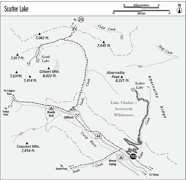
103 Scatter Lake
A day hike or backpack to Scatter Lake, 8.8 miles round-trip.
Best season: Early July to early October.
Elevation gain: 3,750 feet.
Elevation loss: None.
Maximum elevation: 7,050 feet.
Topo maps: Gilbert; Stehekin.
Jurisdiction: Lake Chelan–Sawtooth Wilderness (Okanogan National Forest).
Finding the trailhead: From Twisp, follow Twisp River Road (Forest Road 44) west for 22.2 miles to the Scatter Creek Trailhead.
The Hike
A hike best saved for cool weather, the Scatter Lake Trail climbs 4,000 feet in 4.5 miles to reach the highest lake in the Lake Chelan–Sawtooth Wilderness. From the trailhead, follow the Twisp River Trail westward for a short distance to reach a sign marked Scatter Creek trail. Follow this route, which climbs steadily atop an old logging road. It crosses south-facing slopes that bear selective cuts from the 1960s. This method of logging leaves a few mature trees untouched to reseed the cutover area. It is both more aesthetically pleasing and more ecologically sound than clear-cutting. The trail leaves the old roadbed as it approaches Scatter Creek and begins a long and zigzagging ascent up the mountainside. A sparse woodland of Douglas fir and ponderosa pine offers numerous views of the surrounding country. The Twisp River valley stretches below, guarded by barren peaks. As the trail gains altitude, hikers also get views up the South Creek valley.
After what seems like an interminable climb, the path dips into the Scatter Creek valley, but is still zigzagging upward as it crosses the wilderness boundary. The trail turns north for good beyond the boundary, entering a shady stand of Douglas fir. The trail now embarks on a steep death march, mirroring the precipitous gradient of Scatter Creek. The onslaught continues as subalpine firs replace the montane forest of the lowlands, and grassy meadows soon offer southward views of the twin spires of Reynolds Peak. An old burn dating from 1929 can now be seen on the towering slopes of Abernathy Ridge across the creek.
After a final, steep scramble up a washed-out slope, the trail reaches the grassy benches where the stream forks. A stark prow of stone cleaves the valley in two, and the trail crosses the western fork and follows it upward through a gladed woodland of fir. After a steady climb, the path reaches grassy basin populated by larches, and a spur trail runs to a horse camp at the base of a waterfall. Scatter Lake lies not in this basin but on the shelf above the headwall, and the main trail soon begins its assault upon this final obstacle. Atop the final grade, larch-filled meadows and stagnant pools lead toward the shore of Scatter Lake. This deep pool lies at the foot of Abernathy Peak and is flanked on all sides by barren slopes of broken rock. Trout cruise the icy waters, and a fringe of larches lines the shoreline and the solitary island to provide a colorful counterpoint to the stark nakedness of the rock.
Miles and Directions
0.0 Scatter Creek Trailhead. Follow Twisp River Trail west.
0.2 Junction with Scatter Lake Trail. Turn right.
0.9 Trail climbs into Lake Chelan–Sawtooth Wilderness.
3.5 Forks of Scatter Creek.
3.9 Spur trail runs north to horse camp.
4.4 Scatter Lake.

The final approach to Scatter Lake