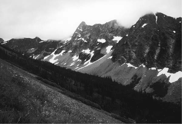
Stiletto Peak from Copper Pass Trail
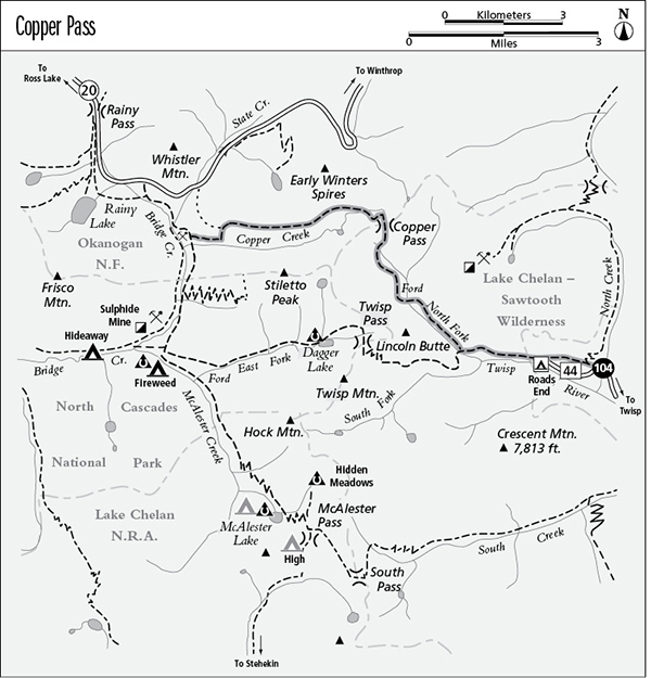
104 Copper Pass
A day hike from North Creek Trailhead to Copper Pass, 12.8 miles round–trip, or a trek to Washington Highway 20, 11.4 miles overall.
Best season: Late June to early October.
Elevation gain: 3,030 feet (east to west).
Elevation loss: 2,440 feet (east to west).
Maximum elevation: 6,710 feet.
Topo maps: Gilbert, McAlester Mountain; Stehekin.
Jurisdiction: Lake Chelan–Sawtooth Wilderness, Okanogan National Forest.
Finding the trailhead: From Twisp, follow Twisp River Road (Forest Road 44) west for 25.3 miles to reach the North Creek trailhead. You can save 0.6 mile by parking at Road’s End Camp and scrambling uphill behind the outhouse to acquire the trail.
The Hike
This primitive trail is no longer maintained between Copper Pass and Bridge Creek, even on the eastern side where the tread is discernible; the uphill grades are brutally steep. Expect route-finding difficulties in the vast meadows of the Copper Creek valley; the route is most easily followed from east to west. At the mouth of the valley, alternate routes run north to intersect WA 20 at the State Creek culvert or down to Copper Creek and west to the trail along the east bank of Bridge Creek. Adventurous souls can combine this trek with Dagger Lake and Twisp Pass for a challenging two- to three-day loop.
The trek begins officially at the North Creek Trailhead, following a wide and dusty track above the road through the Twisp River valley. To save distance, hikers can climb the steep path that intersects the trail as it passes above Road’s End Campground. The trail climbs vigorously for a while, leveling off as it enters the Lake Chelan–Sawtooth Wilderness. The forest is a ragged growth of Douglas fir, with frequent gaps that reveal a rugged spur of Crescent Mountain to the south and the ragged tooth of Lincoln Butte above the head of the valley. As the trail passes the forks of the Twisp River, the gradual ascent steepens markedly and silver fir and spruce become the dominant conifers.
The trail soon reaches a junction beside a pretty waterfall on the North Fork of the Twisp. The footbridge leads to the Twisp Pass Trail, while the trail to Copper Pass lies straight ahead. A steady climb leads up through brushy openings, with the stern countenance of Lincoln Butte rising above the western side of the valley. A silent forest of Engelmann spruce soon closes in around the trail, shading the bottomland trek to a shallow ford of the North Fork.
Stiletto Peak from Copper Pass Trail
The trail soon strikes a rushing tributary that tumbles through a series of cascades. A steep climb beside this stream leads past the ruins of a sod-roofed prospector’s cabin and onto a wooded shelf. The trail wanders past the base of an impressive horn of stone, then begins to climb steeply through the edge of the forest. As the path enters a hanging valley, look southward for views of the spires Kangaroo Ridge. The path is deeply rutted as it climbs into subalpine brushfields of white rhododendron. Watch for marmots in the lowermost boulderfields, and for reclusive pika as the trail climbs into more alpine habitats.
As the trail climbs steadily above the timberline, look eastward to see the rank of rugged peaks that line the Twisp River valley: Lincoln Butte, South Creek Butte, and Crescent Mountain in order of increasing distance. A steep grade leads up to the barren col of Copper Pass, which commands westward views down the Copper Creek valley, with the rock walls of Stiletto Peak rising sheer to the south of it. Snaggletooth peaks rise to the north and east; these are the rear echelons of the Early Winters Spires.
A steep descent leads from the pass to the floor of an alpine basin. After fording the headwaters of Copper Creek, the trail grows faint as it traverses a level course across small alpine meadows bounded by copses of fir. There are a handful of potential campsites along the way. This is delicate country, so take pains to minimize your impact. The alpine meadows give way to a vast grassland that covers the steep north wall of the valley, with the stark cliffs of Stiletto Peak glowering down from across the creek. The faint track stays high on the slope as it skirts around clumps of alder that huddle in the draws or wind-blasted copses of fir.
After a long stretch across open country, the trail reaches the first strips of conifers. A series of precipitous descents leads downward beside the mouth of the valley, with views of Frisco Mountain to the southwest. The beaten track soon bends northward toward the State Creek culvert on the highway; travelers bound for Bridge Creek should continue downward by dead reckoning to reach Copper Creek, then follow the faint prospector’s trail to an intersection with the well-beaten trail along the east bank of Bridge Creek. Turn right to reach the PCT South Trailhead on WA 20.
Miles and Directions
0.0 North Creek Trailhead.
0.6 Trail runs above Road’s End Campground.
2.4 Junction with trail to Twisp Pass. Continue straight ahead.
3.9 Trail fords North Fork of Twisp River.
6.4 Copper Pass. Trail leaves Lake Chelan–Sawtooth Wilderness.
6.9 Headwaters of Copper Creek.
10.4 Junction with east Bridge Creek Trail. Make all right turns for remaining 1 mile (easy) to PCT South Trailhead on WA 20.
11.4 PCT South Trailhead.