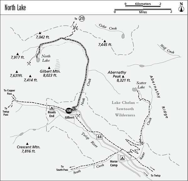
105 North Lake
A day hike to North Lake, 9.6 miles round-trip.
Best season: Mid-June to early October.
Elevation gain: 2,180 feet.
Elevation loss: None.
Maximum elevation: 5,820 feet.
Topo maps: Gilbert; Stehekin.
Jurisdiction: Lake Chelan–Sawtooth Wilderness (Okanogan National Forest).
Finding the trailhead: From Twisp, follow Twisp River Road (Forest Road 44) west for 25.3 miles to the North Creek Trailhead.
The Hike
This wide and well-tended trail offers a moderate day trip to a picturesque lake within the Lake Chelan–Sawtooth Wilderness. It is popular with horse parties; expect to share the trail with them.
The trail begins by zigzagging moderately up the slopes of the Twisp River valley, where selective logging has opened up the forest for fine views of Crescent Mountain crags beyond the river. After gaining 400 vertical feet, the path swings into the North Creek valley. Here, it crosses rugged slopes of broken rock with arid summits all around. As the trail gains altitude, backward glances reveal the graceful summits of Reynolds Peak. The talus slopes give way to meadows of rank grasses, and a scattering of aspens provides splashes of gold in early autumn. The summit of Abernathy Peak is now visible across the valley of North Creek.
As the valley makes a sweeping bend to the west, the trail crosses North Creek, and there are camping spots on the far bank. An old burn has grown back in an open stand of lodgepole pine and subalpine fir, and hikers gain fine views of the granite crags ringing the valley. The trail offers level traveling to its junction with the Cedar Creek Trail, a primitive footpath that surmounts the rocky slopes to the north then makes a long forest trek along Cedar Creek to reach Washington Highway 20. The main trail continues westward, and the forest thickens to provide only fleeting glimpses as it passes the towering walls of Gilbert Mountain. Nearing the head of the valley, the path passes an enormous boulder in the midst of the forest. This is a glacial erratic, borne down from the mountain heights by the glacier that carved this valley during the Pleistocene. The ice deposited the boulder here as it melted away.
Beyond this geological oddity, the trail descends to skirt the edge of a beautiful subalpine meadow. Take a side trip to the campsite at its edge for spectacular views of the surrounding peaks, trimmed with larches that glow green in summer and turn a brilliant yellow in autumn. The trail passes a shallow pond at the upper edge of the meadow, then breaks into the open at the base of a cliff-lined cirque. Entering a shady stand of spruce, the trail passes a junction with the abandoned trail that once climbed to a mine site high above North Lake. The main trail ascends moderately to reach the lake, an emerald pool below the west face of Gilbert Mountain. There are fine campsites in the meadows along its eastern shore, and pikas sometimes call from the talus south of the lake.
Miles and Directions
0.0 North Creek Trailhead.
1.1 Trail enters the Lake Chelan–Sawtooth Wilderness.
2.5 Trail crosses North Creek.
3.4 Junction with Cedar Creek Trail. Keep going straight ahead.
4.3 Junction with abandoned trail to mine site. Bear left for the lake.
4.8 North Lake.

Meadows near North Lake