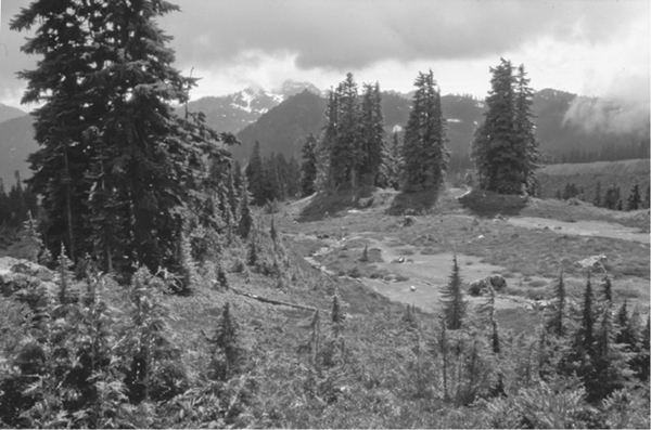
Looking across the valley of Rocky Creek to Loomis Mountain
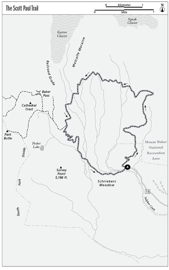
4 The Scott Paul Trail
A daylong loop trip visiting alpine meadows and glaciers on the southeast flank of Mount Baker, 7.5 miles round-trip.
Best season: Late June through September.
Elevation gain: 1,956 feet.
Elevation loss: 1,956 feet.
Maximum elevation: 5,280 feet.
Topo maps: Baker Pass (trail not shown); Green Trails Hamilton #45.
Jurisdiction: Mount Baker–Snoqualmie National Forest (Mount Baker National Recreation Area).
Finding the trailhead: Follow Washington Highway 20 west from Concrete for 5 miles to the Baker River Highway (Forest Road 11) at mile 82.5. Follow this paved road north for 8 miles, then turn left on Forest Road 12 just after entering the national forest. Follow this broad gravel road for 4 miles, then turn right on Forest Road 13 (suitable for low-clearance vehicles) and follow it the remaining 5 miles to the Schriebers Meadow Trailhead.
The Hike
Scott Paul was a popular Forest Service worker who was killed in the line of duty; the trail named in his honor makes a high traverse across the flanks of Mount Baker for nice views of glaciers and abundant wildflowers. This trail is managed for day use only; backcountry camping is not allowed along its length.
The trek begins with a vigorous climb up a ridgeline clad in stout hemlocks. Before long, the path strikes northward to begin a long, climbing traverse through the trees, alternating steady uphill climbs with short level stretches or downhills. The traverse culminates at a pass that overlooks the Sandy Creek valley, with views of the Squak Glacier creeping down the slopes of Mount Baker. The craggy crest of Mount Shuksan can be seen far to the northeast.
Looking across the valley of Rocky Creek to Loomis Mountain
The path now doubles back to the south, ascending into timberline parks crowded with late-blooming heathers and huckleberries. The trail zigzags along, darting westward into vales where the snow collects at a depth that prevents trees from taking root, then dodging eastward to navigate around sharp ridgelets where mountain hemlocks have gained a foothold. Soon the path rises to the foot of a giant jumble of boulders, a terminal moraine bulldozed into place by an advancing glacier in the recent past. The meadows get bigger as the trail wends its way south, yielding views up the slopes of Mount Baker as well as the lesser crags to the south: Loomis Mountain across the valley of Rocky Creek and Twin Sisters Mountain rising to the west above the intervening ridges.
Soon the trail approaches a tall, even wall of rubble. This is the Metcalfe Moraine, a lateral moraine pushed up along the edge of the Easton Glacier during a recent surge. The path reaches the base of the moraine and turns downhill, following the base of the ridge for a while before traversing up to its crest. The path then wanders down into the rock-strewn trough left behind by the retreating glacier, which can be seen to the north, riddled with crevasses and studded with pillars of ice called seracs. This area affords the hike’s best panoramas of Mount Baker, presiding over a barren landscape of rock and ice. After crossing a swaying suspension bridge over Rocky Creek, the path traverses across the lateral moraine on the far side, so even and regular its climb that it has been named the Railroad Grade.
From here, the path jogs west through the trees to meet the Park Butte trail. Bear left to begin the foot-pounding descent via a series of tight switchbacks as the route drops through an open forest that showcases the craggy face of Snowy Point rising across a steep gorge. At the bottom of the grade is a boulderfield where hoary marmots may be spotted. The trail makes its way to a footlog crossing of Rocky Creek for final views of Mount Baker, then runs out onto the flats of Schriebers Meadow. Here, the trees thin out as marshy clearings filled with cottongrass (not a true grass, but a flowering sedge with seed heads that form cottony tufts). A leisurely stroll leads the traveler back to a bridge over Sulphur Creek to return to the trailhead.
Miles and Directions
0.0Hike begins at Schriebers Meadow Trailhead.
2.2Trail reaches saddle overlooking Sandy Creek drainage and turns south.
4.0Metcalfe Moraine.
4.5First crossing of Rocky Creek via bridge.
5.0Junction with Park Butte Trail. Turn left to complete loop.
6.7Second crossing of Rocky Creek via footlog.
7.4Bridge leads across Sulphur Creek.
7.5Schriebers Meadow Trailhead.