
Looking into the Monogram Lake Basin
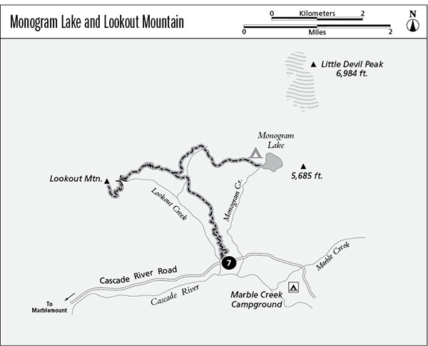
7 Monogram Lake and Lookout Mountain
A long day hike or backpack to either Monogram Lake (9.8 miles round-trip) or Lookout Mountain (9.4 miles round-trip).
Best season: Mid-July to mid-October for Lookout Mountain; late July to mid-October for Monogram Lake.
Elevation gain: 4,095 feet to Monogram Lake; 4,444 feet to Lookout Mountain.
Elevation loss: 470 feet to Monogram Lake.
Maximum elevation: 5,699 feet at Lookout Mountain.
Topo maps: Big Devil Peak; Marblemount.
Jurisdiction: Mount Baker–Snoqualmie National Forest, North Cascades National Park.
Finding the trailhead: From Marblemount, follow the Cascade River Road across the bridge. Follow this road past the pavement’s end to the Monogram Lake Trailhead at mile 9.1.
The Hike
This trail enjoys enormous popularity as one of the fastest routes to the high country from the Marblemount Ranger Station. Legions of day hikers set out each weekend, bound for Monogram Lake, one of the true alpine gems of the North Cascades, and for the old fire tower atop Lookout Mountain. Few make it; the tedious 2,500-foot climb up the forested walls of the Cascade River valley is merely a prelude to the near-vertical angler’s trail that leads to Monogram Lake. The climb to the lookout is gentler, but no peach either. A volunteer organization maintains the fire tower, and it is open for overnight stays on a first-come first-served basis. Monogram Lake lies just within the national park boundary, and permits are required for backpackers. Cutthroats inhabit the lake and offer spectacular fishing.
The trek begins with a relentless, zigzagging climb through heavy timber. Mature hemlocks provide unbroken shade for the ascent, and moss carpets the forest floor. About halfway up the grade, views down the valley can be had from the top of a stone outcrop. As the trail continues to gain altitude, rushing streams can be heard on both sides of the trail, but there is no easy way to get to the water.
Looking into the Monogram Lake Basin
At the top of the initial slope, the trail passes a spring and a pitiful little camping spot at the edge of a landslide scar. To the west, conifers are tilted at crazy angles, attesting to the downhill slumping of the soil beneath them. The trail climbs through a brushy avalanche swath that is filled with cow parsnip, salmonberry, and stinging nettle. A backward glance yields views of the southwestern buttress of Eldorado Peak. At the top of the brushy stretch, the trail turns west and the gradient eases for a while. The forest is now dominated by ancient hemlocks intermixed with younger silver firs, which are even more shade-tolerant. The trail crosses a substantial stream, then rounds a finger ridge to reach a trail junction on the slope beyond. The main trail continues straight ahead toward Lookout Mountain; lake-bound travelers should turn right onto the fainter trail.
The rough track to Monogram Lake ascends through the subalpine forest with brutal uphill pitches. It passes along the edge of an old burn, then resumes its merciless ascent through the trees. The path ultimately levels off and turns eastward, and flowery glades begin to interrupt the forest. A meadow-strewn bowl stretches ahead, and the trail crosses it before climbing over a spur ridge that yields mountain views that stretch from horizon to horizon. To the north the rugged crags of Bacon Peak are dwarfed by the snowy massif of Mount Baker, and close at hand is the tower atop Lookout Mountain. As the trail crests the ridge, astounding views open up to the east, encompassing most of the glacier-clad summits that guard the Cascade River as well as the distant summit of Glacier Peak far to the south.
The trail descends steadily across slopes of heather and glacier lilies, making a beeline for the deep waters of Monogram Lake. The lake is situated beneath a small peak of its own, from which waterfalls descend into the basin. Marmots are abundant here, and black bears are sighted frequently. Campers and anglers should tread lightly as they enjoy the fragile lakeshore environs, where alpine plants are easily damaged by trampling.
Miles and Directions
0.0Trailhead on Cascade River Road.
2.8Trail junction. Bear left for Lookout Mountain (1.9 more miles) or turn right for Monogram Lake.
4.9Monogram Lake.
Lookout Mountain Option
Upon leaving the high trail junction, this route climbs gradually through the forest on a westward heading. The trees are soon interrupted by pleasant glades filled with alpine wildflowers. The path ultimately reaches a steep meadow, richly carpeted with blossoms throughout the summer. There are good views of Little Devil Peak from this point. At the far edge of the slope, the trail zigzags up to a wooded saddle, then begins its assault on the eastern face of Lookout Mountain. Open meadows on the way up reveal outstanding views of Eldorado Peak. The lookout tower rises from the summit, commanding views of the Skagit Valley and the innumerable peaks of the North Cascades. The lookout is no longer staffed but is open to public use, with priority given to lookout maintenance crews.