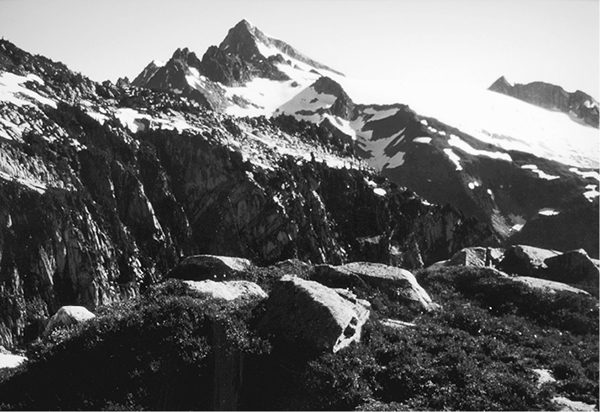
Eldorado Peak from ridge below Hidden Lake Lookout
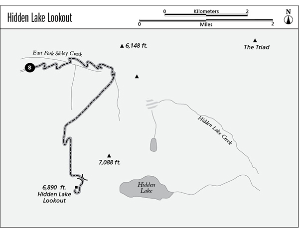
8 Hidden Lake Lookout
A day hike to Hidden Lake Lookout, 7.4 miles round-trip.
Best season: Mid-July to mid-October (expect snow in upper reaches).
Elevation gain: 3,210 feet.
Maximum elevation: 5,699 feet at Hidden Lake Lookout.
Topo maps: Eldorado Peak, Sonny Boy Lakes; Diablo Lake, Cascade Pass.
Jurisdiction: Mount Baker–Snoqualmie National Forest, North Cascades National Park.
Finding the trailhead: From Marblemount, follow the Cascade River Road across the bridge. Follow this road past the pavement’s end to mile 10.2 and a junction with Forest Road 1540. This steep and narrow road winds upward for 4.7 miles to reach the trailhead.
The Hike
This popular day hike starts near timberline and climbs to the mountaintops for superb views of the glacier-clad peaks that line the Cascade River. The old fire lookout atop Hidden Lake Peak is now maintained by a volunteer group for overnight stays. There is no fee (although donations are welcome); get there early if you plan to sleep in the lookout, because it’s a first-come first-served proposition. Hikers who wish to camp in the basin of Hidden Lake must have a National Park Service permit and be prepared for the scrambling required to descend to level ground.
From the parking lot, the trail crosses some brushy streams then zigzags upward through a climax forest of silver fir. After 0.4 mile, the path breaks into an open basin where the East Fork of Sibley Creek has its origins. The trail soon climbs out of a riot of cow parsnip, fireweed, and false hellebore to reach the sloping meadows of the bowl. The upper slopes support a riot of wildflowers, and hoary marmots and black bears are often spotted here. High in the basin, the lofty cone of Mount Baker becomes visible far to the northwest, while the lesser cockscomb of Sauk Mountain rises in the middle distance.
After a long and vigorous climb, the trail reaches alpine slopes robed in heather and dwarf blueberry. It now levels off on a southward heading, and sparkling brooks of all descriptions course down through the boulder-strewn meadows. Snowy summits rise above sawback ridges to the north. A spur trail soon leads westward to a campsite on a high perch, while the main trail continues a gentle ascent toward a spur ridge clad in full-grown mountain hemlock. Upon gaining the ridge, look eastward for spectacular views featuring the western summits of Eldorado Peak.
Eldorado Peak from ridge below Hidden Lake Lookout
The trail now climbs across a dome of bedrock, and the glacier-clad summit of Snowking Mountain becomes visible to the southwest. There is another high camp in this area, near snowmelt pools that thaw in late summer. Listen for the kazoo-like warning call of the pika, a short-eared member of the rabbit clan. The path now snakes upward along ridges of frost-riven granite, and a ragged summit rises ahead. The trail, often covered in snow here, climbs into the saddle to the north of the peak and ends.
This rocky col offers superb views of Hidden Lake in its basin of fractured rock, with Forbidden Peak and Sahale Mountain ranged beyond it to the east. The broad icefield between the peaks is the Quien Sabe Glacier. To the southwest is a crowd of imposing summits: Johannesburg Mountain, Spider Mountain and Middle Cascade Glacier, Mount Formidable rising in front of it, Sentinel Peak with its snow domes, Dome Peak, and finally Spire Peak embracing Spire Glacier.
Adventurous travelers might opt to undertake the steep and hazardous scramble from the pass down the snowfields and talus slopes to the shores of Hidden Lake. According to legend, trout of mythic proportions can be found here during the brief ice-free season.
A cairn- and paint-marked route leads south across the mountainside, then climbs to reach the old Hidden Lake fire lookout. The structure was built in 1933 and is currently maintained as a public shelter. The lookout boasts superb views that encompass Eldorado Peak to the north and Glacier Peak far to the south. On a clear day, Mount Rainier can be seen just to the left of Snowking Mountain.
Miles and Directions
0.0Hidden Lake Trailhead.
0.5Trail crosses the East Fork of Sibley Creek.
3.4Pass overlooking Hidden Lake.
3.7Hidden Lake Lookout.