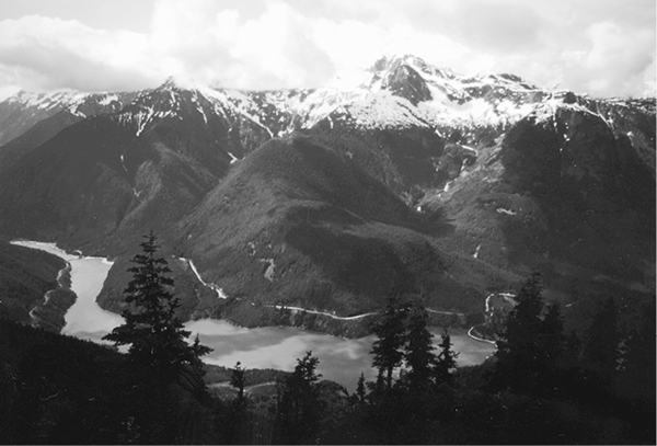
Diablo Lake from Sourdough Lookout
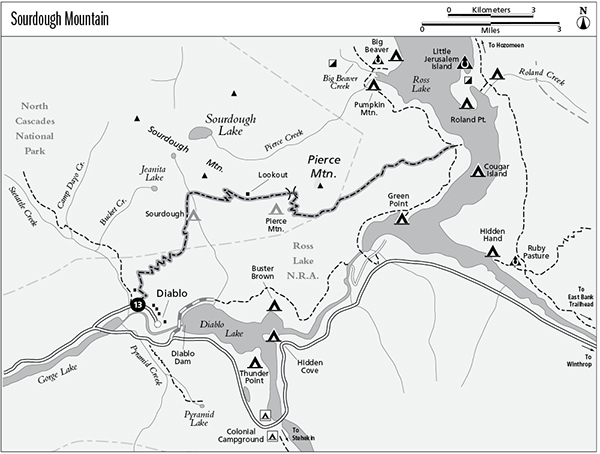
13 Sourdough Mountain
A long day hike to Sourdough Mountain Lookout, 10.4 miles round-trip, or a backpack to the West Bank Trail, 11.1 miles one way.
Best season: Mid-July to mid-October.
Elevation gain: 5,095 feet, west to east.
Elevation loss: 3,895 feet, west to east.
Maximum elevation: 5,985 feet at Sourdough Mountain Lookout.
Topo maps: Diablo Dam, Ross Dam, Pumpkin Mountain; Diablo Lake, Ross Lake.
Jurisdiction: Ross Lake National Recreation Area, North Cascades National Park.
Finding the trailhead: Follow Washington Highway 20 to mile 126 and take the paved access road to Diablo. Park across from the swimming pool; the trail begins beside the pool. The trail ends at mile 3.8 on the West Bank Trail.
The Hike
This popular trail can be approached via a long ascent from the town of Diablo or by a longer (9.7 miles one way) but easier route via the West Bank Trail. The trail makes a nice two-day loop when combined with the West Bank and Diablo Lake Trails; hike it counterclockwise for easiest traveling. Atop Sourdough Mountain, an active fire lookout offers superb views of Diablo Lake and snowcapped peaks stretching in all directions. One of the first fire lookouts in the nation was built here in 1917 by Glee Davis. The original log cabin with its 6-foot-square cupola was replaced with the current structure during the Great Depression.
From Diablo, the trail embarks immediately on a long and vigorous ascent up the steep mountainsides above Stetattle Creek. After a steep initial pitch, a grassy slope reveals southward views of Colonial and Pyramid Peaks. The gradient eases as the trail settles into a steady zigzagging ascent across dry slopes covered with lodgepole pine. Small ravines and hollows here have a moister microclimate, favoring water-loving plants, such as sword fern, Douglas maple, and red alder. As the trail climbs higher, the sparse forest canopy reveals fine views of Davis Peak and Mount Terror beyond the Stetattle Creek valley. The path ultimately climbs onto south-facing slopes covered in large Douglas firs. The lower limbs of these trees are draped with old man’s beard, a lichen that is a winter staple for browsing deer.
At mile 3.0, the path crosses a sparsely wooded ridgetop overgrown with huckleberry bushes. A faint track climbs to a microwave relay station, while the main trail makes its way onto east-facing slopes within the national park boundary. Here, an open subalpine forest reveals views of Ruby Mountain and later of Diablo Lake. The peculiar turquoise tint of the lake is derived from fine glacial sediments, known as gletschermilch, suspended in the water. The sediments diffract light that enters the water in such a way that only blue and green light escapes.
The path traverses steep slopes to Sourdough Creek, where a camping spot is nestled amid heather meadows. It is common for snowdrifts to linger in this area well into July. Sourdough Creek follows a major fault in the bedrock, the same rift that accounts for the larger Thunder Creek valley to the south. Movement along such faults weakens the bedrock along the rift, hastening erosion and thus prompting the formation of linear drainages along the fault line.
Diablo Lake from Sourdough Lookout
The trail now turns east, climbing through stands of mountain hemlock to reach open swards of wildflowers beyond. The views from these slopes are superb, encompassing a broad arc of mountainous country to the south. Of particular note is Boston Glacier, a broad icefield that mantles the slopes at the head of the Thunder Creek watershed. The path zigzags steadily upward to reach the high alpine country of the ridgetop, where snow lingers well into July. Look northwest for a view of Sourdough Lake, with the Picket Range rising beyond it.
The path climbs along the ridgeline to its zenith at the lookout, with spectacular views in all directions. In addition to the now-familiar scenery to the west and south, the tall edifice of Jack Mountain rises beyond Ross Lake, with the jagged granite spires of the Golden Horn Batholith crowding the eastern horizon.
The trail continues down the far side of the ridge, marked by cairns where snows linger late into summer. Snowslips and broken talus gradually give way to a rock garden of heather and mountain hemlock as the ridgetop levels off somewhat. Pierce Mountain Camp occupies a rocky shelf in the parklands, with a small snowmelt pool to provide drinking water. Filter plenty of water for the arid descent to Ross Lake. The trail descends to the low saddle behind Pierce Mountain, then drops onto south-facing slopes. The views are rewarding, featuring Jack and Ruby Mountains as well as the glacier-mantled summit of Colonial Peak.
Upon returning to the forest, the trail follows an eastward-trending finger ridge across the boundary into Ross Lake National Recreation Area. The path tracks the rounded crest of this ridge, sometimes descending steeply, otherwise leveling off for extended periods. The loose forest of hemlocks affords few distant views, but hikers get a final look at Jack Mountain near the bottom of the grade. Here, the route joins the West Bank Trail and a faint path drops to the shore of Ross Lake.
Miles and Directions
0.0Trailhead in the settlement of Diablo.
3.2Trail leaves Ross Lake NRA and enters North Cascades National Park.
4.1Sourdough Creek Camp.
4.2Trail crosses Sourdough Creek.
5.0Trail reaches top of Sourdough Mountain.
5.2Sourdough Mountain Lookout. Trail begins to descend.
6.2Pierce Mountain Camp.
6.4Trail leaves the ridgecrest and descends into an old burn.
7.4Trail leaves North Cascades National Park and enters Ross Lake NRA.
11.1Trail ends at a junction with West Bank Trail.