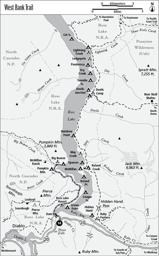
Along the West Bank Trail
14 West Bank Trail
A connecting trail linking Washington Highway 20 with Big Beaver Creek, 7.1 miles overall.
Best season: Mid-May to early November.
Elevation gain: 840 feet.
Elevation loss: 1,250 feet.
Maximum elevation: 2,100 feet.
Topo maps: Ross Dam, Pumpkin Mountain; Diablo Lake, Ross Lake.
Jurisdiction: Ross Lake National Recreation Area, North Cascades National Park.
Finding the trailhead: The trail begins at the Ross Dam Trailhead at mile 134 on Washington Highway 20, 4 miles east of Colonial Campground.
The Hike
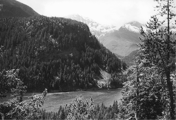
This connecting trail links WA 20 with the Big Beaver Trail via Ross Dam. It follows the western shore of Ross Lake, with occasional views of the water and access to the Ross Lake Resort, Green Point and Pumpkin Mountain camps, and the east end of the Sourdough Mountain Trail. Seldom hiked as a trip unto itself, this trail is an important link for backpackers on extended journeys into the mountains west of Ross Lake.
The Ross Dam Trailhead sits on a bluff high above the lakeshore, and from its large parking lot the path wanders downward through storm-wracked Douglas firs. The path passes a small cascade on Happy Creek, then drops across an open and rocky face that yields views of Pyramid Peak to the southwest. The trail bottoms out on a service road; turn left and then right, following signs for Ross Dam. The route then leads across the top of the dam, its curving façade of concrete rising 540 feet above the Skagit River. The dam was constructed between 1937 and 1949 and flooded the Skagit Valley for 21 miles upstream.
On the far shore, the trail begins a brisk ascent as it turns eastward above the lake. An opening atop the initial grade yields views of Ruby Mountain and a waterfall on the far shore. These falls are not natural but were created when engineers diverted part of Happy Creek to enter Ross Lake above the dam, thus increasing the water available for hydropower. The trail maintains a constant elevation above the shoreline as it passes through a mixed woodland of birch and conifers. Steep side paths descend to the lakeshore at Ross Lake Resort and later at Green Point Camp.
Along the West Bank Trail
Just beyond the campground junction is a rocky overlook that commands a fine panorama, highlighted by views up the Ruby Arm of Ross Lake and down-valley to Colonial and Pyramid Peaks. The path soon enters a burn dating from 1926 that has grown up in a doghair stand of lodgepole pine and Douglas fir. This forest community arises when thickets of fire-adapted seedlings spring up “thicker than the hair on a dog’s back” on mineral-rich ashes after a blaze. Numerous openings offer views of the lake, with Jack Mountain towering above it.
As the trail rounds the headland, the young trees give way to old Douglas firs that block out the views. The Sourdough Mountain Trail soon climbs away to the west, while the West Bank Trail winds onto north-facing slopes. Here, a cool, moist forest of hemlock and western red cedar is underlain by a verdant carpet of fern moss. Stony promontories with dry, shallow soils harbor stands of lodgepole pine and allow the first northward views of Pumpkin Mountain’s wooded dome. The trail now begins a gradual ascent as the peaks flanking Big Beaver Creek come into view. The trail tops out above a spectacular cataract on Pierce Creek, where water thunders through a perilous gorge.
The trail then descends vigorously to the banks of Big Beaver Creek, passing the woodland campground of Pumpkin Mountain along the way. A suspension bridge spans Big Beaver Creek, and beyond it is a junction where trails run westward along the creek and east to Big Beaver Camp on the lakeshore.
Miles and Directions
0.0Trailhead above Ross Dam.
0.7Trail runs onto dam access road. Turn left.
0.9Trail crosses Ross Dam and follows the shore of Ross Lake.
1.6Spur trail descends to Ross Lake Resort.
1.9Spur trail descends to Green Point Camp.
3.8Junction with Sourdough Mountain Trail. Continue straight ahead.
6.0Trail crosses Pierce Creek.
6.9Spur path descends to Pumpkin Mountain Camp.
7.0Trail crosses Big Beaver Creek.
7.1Junction with Big Beaver Trail.