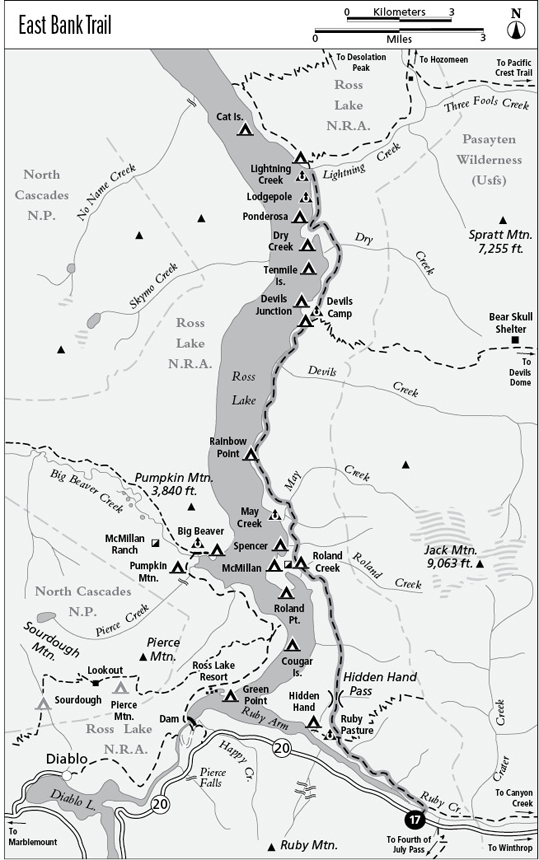
17 East Bank Trail
A backpack along Ross Lake to the mouth of Lightning Creek, 16 miles overall.
Best season: Early June to late October.
Elevation gain: 1,297 feet.
Elevation loss: 1,525 feet.
Maximum elevation: 2,520 feet at Hidden Hand Pass.
Topo maps: Crater Mountain, Ross Dam, Pumpkin Mountain; Diablo Lake, Mount Logan, Ross Lake.
Jurisdiction: Ross Lake National Recreation Area, North Cascades National Park.
Finding the trailhead: The trail leaves from Washington Highway 20 at the East Bank Trailhead, at mile 138.2 (19 miles east of Newhalem).
The Hike
This trail makes a long trek through the forest, roughly following the eastern shore of Ross Lake. The lake is in view only sporadically, with the best vistas coming between Rainbow Point and the mouth of Devils Creek. The East Bank Trail is an integral leg of the Devils Dome loop trek and can also be combined with the Lightning Creek and Three Fools Trails for longer trips.
The trail begins with a descent from the highway to the confluence of Ruby and Panther Creeks. Interpretive signs tell of the Ruby Creek gold rush of 1879, when the banks of Ruby Creek were staked from end to end with placer claims. A prospect pit, or “glory hole,” lies beside the interpretive display. A suspension bridge leads across Ruby Creek, and beyond it the trail climbs to an old roadbed and follows it downstream. This road was built in 1938 in a failed effort to breach the Cascades Divide via Harts Pass and link the mines on Slate Creek with markets to the west. The old road traverses the slopes high above Ruby Creek, passing through a mixed woodland of birch, red alder, and Douglas fir.
As the creek pours into the Ruby Arm of Ross Lake far below, the roadbed passes above the flooded site of the Ruby Mining Company’s ill-fated operation. The company was formed in 1906 in a vain attempt to reap fortunes by consolidating the small placer claims and mining them on a large scale with giant hydraulic cannons and diversion flumes. After a $300,000 investment in capital yielded only $3,000 in gold, the company folded. Watch the gaps in the forest for views of Ruby Mountain, with the cascades of Lillian Creek tumbling down its flanks.
The trail ultimately reaches a well-marked junction. The wide trail straight ahead leads past the Ruby Pasture and Hidden Hand camps to a clifftop overlook of Ross Lake. The smaller trail that climbs to the north is the East Bank Trail, from which the Little Jack Trail soon breaks away. The main trail now skirts the upper edge of Ruby Pasture, where the Forest Service once built an extensive guard station using lumber from the ruins of the Ruby Mining Company. The guard station was itself abandoned, and the pastures have become overgrown with brush.
A short climb leads to Hidden Hand Pass, where a swampy forest occupies the long gap behind a stony hillock. According to local legend, prospector Jack Rowley was prospecting near this spot when he had a dream in which a hidden hand guided him to the spot on Canyon Creek where he was to make the gold strike that started the Ruby Creek rush. After passing through the gap, the trail maintains its altitude as it charts an inland course through a diverse array of forest habitats. Open stands of Douglas fir alternate with groves of birch and bigleaf maple, cedar swamps, and corridors of moss-hung vine maple suffused with green.
The trail encounters a camping area on the far bank of Roland Creek, and an unmarked path descends on a westward heading to the shore of Ross Lake. Tommy Rowland’s homestead once occupied the base of a small peninsula nearby. Perhaps the isolation was too much for the Irish settler; he insisted that he was an incarnation of the Prophet Elijah and took to calling his home “Little Jerusalem.” His prophetic ravings earned him a trip to the lunatic asylum, but he escaped and returned here before he was finally committed for good.
A short distance beyond Roland Creek, the trail approaches the shore of Ross Lake for the first time, with views of the mountains flanking Big Beaver Creek. The path then journeys inland once more, ultimately crossing May Creek in the deep shade of a mossy defile. This stream carries the meltwater of Nohokomeen Glacier, which sits high on the flanks of Jack Mountain, obscured by trees. The path that runs down the south bank leads to a horse camp, while the main trail continues northward. The latter trail emerges from the timber at Rainbow Point, where a camp commands beautiful views up and down Ross Lake.
The East Bank Trail now hugs the lakeshore, yielding the finest views of the trek. Just south of Devils Creek, the route has been blasted out of sheer cliffs, and solid bedrock overhangs the pathway in several places. A suspension bridge spans the narrow cove where Devils Creek enters the lake. On the far side, the trail climbs for several hundred feet, then levels off amid a woodland of birch and grand fir. The path plods along through the forest to reach a junction with the Devils Dome Trail, and below the junction is a camp spot on a high and wooded knoll.
For the next several miles, the only sights that break the monotony of the forest are provided by the tributary streams that tumble down through the timber. As it passes a shallow bay, the trail reveals brief glimpses of the lake, then climbs through a low saddle. A gradual descent leads past Lodgepole Camp to the mouth of Lightning Creek, where the trek ends and trails continue northward to Desolation Peak and Hozomeen Lake. There is a horse camp on the south side of Lightning Creek’s mouth, while a hiker camp lies north of the suspension bridge.
Miles and Directions
0.0Trailhead on WA 20.
0.3Trail crosses Ruby Creek to meet Ruby Creek Trail. Turn left.
2.8Junction with spur trail to Ruby Pasture Camp, Hidden Hand Camp, and Ruby Arm overlook (0.6 mile, easy). Turn right for East Bank Trail.
2.85Junction with Little Jack Trail. Bear left as main trail starts to climb.
3.9Hidden Hand Pass.
6.5Trail crosses Roland Creek to reach Roland Creek Camp.
7.8Trail crosses May Creek. Spur trail runs downstream to horse camp.
8.7Rainbow Point Camp. Trail follows shore of Ross Lake.
11.0Bridge over mouth of Devils Creek. Trail leaves lakeshore.
12.4Junctions with Devils Dome Trail and spur paths to Devils Creek and Devils Junction camps. Continue straight ahead for Lightning Creek.
14.0Trail crosses Dry Creek.
15.6Spur trail descends to Lodgepole horse camp.
15.8Lightning Creek horse camp.
15.9Trail crosses mouth of Lightning Creek.
16.0Trail ends at junctions with Desolation Peak Trail, Lightning Creek Trail, and spur to Lightning Creek hiker camp.