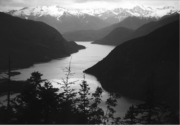
Ross Lake from Desolation Peak
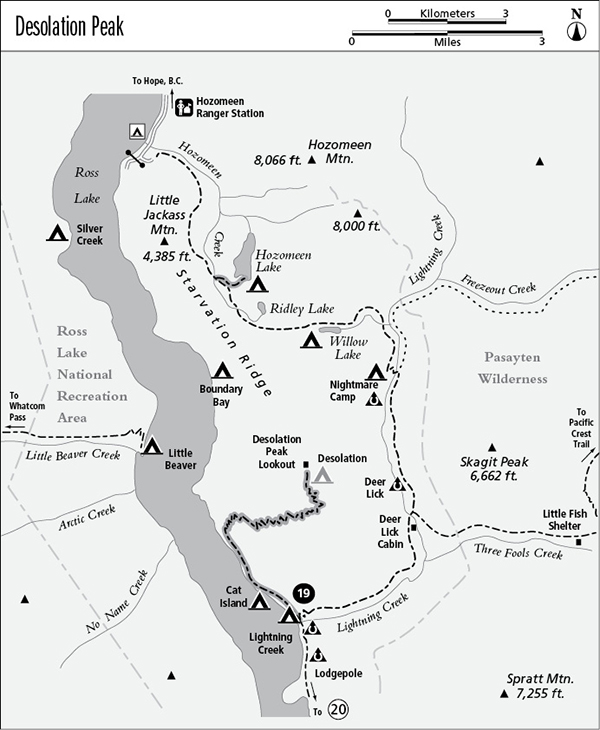
19 Desolation Peak
A day hike from Lightning Creek Camp to the summit of Desolation Peak, 13.6 miles round-trip, or from the Jack Point boat landing to the summit, 9.8 miles round-trip.
Best season: Late June to mid-October.
Elevation gain: 4,532 feet.
Elevation loss: 80 feet.
Maximum elevation: 6,102 feet at Desolation Peak.
Topo maps: Hozomeen Mountain; Ross Lake.
Jurisdiction: Ross Lake National Recreation Area.
Finding the trailhead: The hike can be approached from Lightning Creek Camp (14.1 miles by trail from Hozomeen; 16 miles from Washington Highway 20) or from a poorly marked boat landing on Ross Lake, about 2 miles north of the mouth of Lightning Creek.
The Hike
This trail makes a good day trip for hikers based at the mouth of Lightning Creek. Visitors who are traveling Ross Lake by boat may access the trail by hauling out at a poorly marked trailhead in a small cove 2 miles north of Lightning Creek. The trail presents a challenging climb to the summit of Desolation Peak, where a fire lookout station commands fine views of the surrounding ranges. During the tinder-dry summer of 1926, a wildfire ignited in the Big Beaver Creek valley and spread rapidly eastward, expanding to engulf this low peak that guarded what was then the eastern bank of the Skagit River. The mountain was named Desolation Peak in the wake of this blaze, and a fire lookout was built atop it to help prevent future wildfires. The lookout has been the summer home to a succession of writers and artists over the years. The best-known luminary to stand watch here was Jack Kerouac, beatnik novelist and inveterate wanderer. His season as a fire lookout in 1956 inspired him to write the novel Desolation Angels.
From the bridge that spans the mouth of Lightning Creek, hike northward on the trail that runs above the shore of Ross Lake. Bear right as a spur path descends to the Lightning Creek hiker camp, then continue straight ahead as the Lightning Creek Trail climbs away to the right. You are now on the trail to Desolation Peak, which maintains a constant altitude above the lakeshore as it charts a level northward course. Openings in the forest are plentiful, first yielding views down Ross Lake and later revealing Cat Island and the waterfalls on the far shore. After 2.1 miles, a spur trail descends to an unimproved boat landing on the lakeshore; waterborne hikers can start the trek at this point.
Ross Lake from Desolation Peak
The trail now begins its upward journey, climbing through an open forest that shows scars of the blaze that once razed the trees on Desolation Peak. Colonizing shrubs such as ceanothus and wild rose grow in the abundant sunlight of the forest openings. About a third of the way up the mountain, the open meadows give way to a dense growth of young conifers. The drier conditions of the lower slopes prevented rapid reforestation, but here the trees are making a strong comeback, aided by ample moisture.
The trail stays in the forest as it climbs vigorously between brush-choked avalanche paths. When it emerges into flowery pocket meadows, it offers outstanding views of Ross Lake, highlighted by the distant massif of Colonial Peak, with Paul Bunyan’s Stump to the right of it and Colonial Glacier at its foot. Later, there are excellent vistas of Jack Mountain, with spectacular Nohokomeen Glacier gracing its north face. The trail soon finds its way into a steep-sided bowl covered in a mixture of alpine wildflowers and shrubs. This area is particularly favored by foraging black bears during early summer. The path zigzags up to the ridgetop, where a short spur runs south to Desolation Camp. The camp offers superb views of Jack and Spratt Mountains, but water can be hard to come by.
Meanwhile, the main trail turns north toward a false summit robed in meadows and dotted with copses of subalpine fir. After cresting the top of this rise, hikers can see the rocky summit of Desolation Peak ahead, crowned with its fire lookout station. Here the trail ends with views in all directions, described by Kerouac as “hundreds of miles of snow-covered rock all around, looming Mount Hozomeen on my north, vast snowy Jack to the south, the encharmed picture of the lake below to the west and the snowy hump of Mount Baker beyond, and to the east the rilled and ridged monstrosities humping to the Cascade Ridge.” Even the loo has a view: The open-air toilet is perched on the edge of a cliff, looking out over the Lightning Creek valley toward Freezeout Mountain and other barren peaks of the Pasayten Wilderness.
Miles and Directions
0.0Junction with Lightning Creek Trail. Bear north.
2.1Junction with spur trail to Jack Point boat landing. Turn right as the trail begins to climb Desolation Peak.
5.8Trail tops the ridgeline at Desolation Camp.
6.8Desolation Peak Lookout.