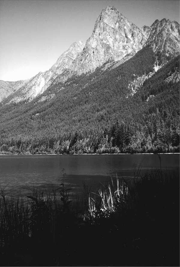
Hozomeen Lake photo by melanie davidson
20 Lightning Creek and Hozomeen Lake
A day hike to Hozomeen Lake, 7.8 miles round-trip, or a backpack to Ross Lake, 14.1 miles overall.
Best season: Early June to late October.
Elevation gain: 2,530 feet.
Elevation loss: 2,570 feet.
Maximum elevation: 2,900 feet.
Topo maps: Hozomeen Mountain, Skagit Peak; Ross Lake, Jack Mountain.
Jurisdiction: Ross Lake National Recreation Area.
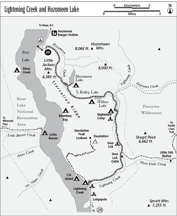
Finding the trailhead: From the western edge of Hope, British Columbia, follow the Silver-Skagit Road south for 38 miles to the U.S.–Canada border. This road has a broad, gravel surface that may have numerous potholes and washboards. Once in the United States, drive past the ranger station and take the second left, which accesses a campground loop. The trailhead is at the end of this road, beside a historic customs station.
The Hike
This trail offers a northern route to the eastern shore of Ross Lake and provides access to several lowland lakes along the way. The largest of these, Hozomeen Lake, reflects the striking crags of Hozomeen Mountain, and it is a popular day hike from Hozomeen. The longer trail along Lightning Creek makes an easy circuit around Desolation Peak, passing through fine stands of old-growth timber along the middle reaches of the creek before climbing above a narrow canyon to reach Ross Lake. This trail links up with the Three Fools Trail, the East Bank Trail, and the Desolation Peak Trail for extended forays into the backcountry.
The trail begins beside a historic U.S. Customs cabin and ascends briskly through the timber above the Hozomeen Campground. The forest soon thins to a sparse growth of spindly Douglas firs and lodgepole pines, the sure sign of an old burn. The thin and stony soil is covered with mosses and foliose lichens, which are related to the caribou moss of the Arctic tundra. At the top of the initial grade, the trail reaches a level upland where stately cedars grow. The gradient is gentler now, and it remains so as far as the junction with the spur path to Hozomeen Lake. This side trail leads 0.6 mile through a broad watershed divide to reach the lake, a vast lowland pool that lies at the foot of Hozomeen Mountain. Hozomeen means “sharp like a knife” in the local Native dialect, an appropriate description of the several sheer crags that rise from the massif. Mule deer are abundant (and sometimes pestiferous) here, and loons commonly are spotted on the still waters. There is a pretty campground at the south end of the lake, and visitors will find fair fishing for brook trout.
Meanwhile, the Lightning Creek Trail continues eastward through the forest, rising and falling gently with the folds in the terrain. The trees ultimately thin out, and huckleberry bushes grow abundantly in the sunny understory. The path soon reaches the head of Willow Lake, where a campsite shaded by cottonwoods guards the shallow woodland pool. The lake is gradually filling in with sediment, and shrubs are encroaching at its margins. The lake will ultimately become a brushy meadow, which will in turn give way to conifers as forest succession runs its course.
The trail follows the north shore of the mere, then strikes out through tall timber. The path strikes the outlet stream at a pleasant waterfall and follows the brook downward toward Lightning Creek. Its valley is level at first, with immense cedars that tower above an undergrowth of salmonberry and devil’s club. Then the gradient steepens, and the stream plunges through mossy cascades shaded by a mature forest of hemlock. After a vigorous descent, the trail turns south along the edge of the Lightning Creek valley. A few steep drops carry the trail down into the bottomlands, where it reaches Nightmare Camp. This camp is set amid the massive boles of old-growth cedars.
Hozomeen Lake photo by melanie davidson
A footbridge spans Lightning Creek, and beyond it the trail follows the stream downward. Convoluted hillsides soon give way to level terraces, their ancient sediments laid down by glaciers to form the ancestral valley floor. Lightning Creek has since cut down through them, leaving them stranded high above the new bottomlands. A dense growth of hemlock saplings now borders the trail, which occupies a wide swath cut through the forest.
Just before the junction with the Three Fools Trail, Deer Lick Camp occupies a small clearing in the forest above the creek. Beyond the junction, the trail descends to a stock bridge over Lightning Creek. On the far bank is the Deer Lick Cabin, built for the Forest Service by a prominent Native American pioneer named Leonard Bacon.
Beyond the cabin, the trail climbs steadily through the forest. The towering cedars of the bottomlands are soon replaced by trees that grew in the wake of the 1926 fire that started along Big Beaver Creek and burned much of the upper Skagit Valley. The streamcourse is now far below, and the trail follows it, bending around the mountainside onto an eastward heading. There are periodic openings where old Douglas firs grow sparsely, and these allow views down into the steep-walled canyon. Spratt Mountain is the massive peak beyond the canyon. The path rises and falls, maintaining a level gradient as the chasm grows deeper. Soon the trail is more than a thousand feet above the rushing water.
Near the mouth of the creek are fine views of Ross Lake and the snowclad peaks that surround it. The trail then switchbacks steadily downward to the lakeshore. Bear left at the two trail junctions to reach the suspension bridge that spans the cove where Lightning Creek empties into Ross Lake.
Miles and Directions
0.0Trailhead at old Hozomeen Customs cabin.
3.0Trail crosses Hozomeen Creek.
3.1Junction with spur trail to Hozomeen Lake (0.8 mile, easy). Bear right for Lightning Creek.
5.1Head of Willow Lake and spur trail to Willow Lake Camp.
5.5Trail leaves Willow Lake.
7.8Nightmare Camp. Trail crosses Lightning Creek and follows its east bank.
10.2Deer Lick Camp.
10.3Junction with Three Fools Trail. Bear right for Ross Lake.
10.4Trail crosses Lightning Creek to reach Deer Lick Cabin.
12.7Top of grade that descends to Ross Lake.
14.1Trail ends at junction above Lightning Creek hiker camp.