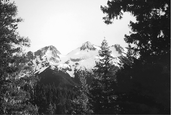
Tricouni Peak from Fourth of July camp
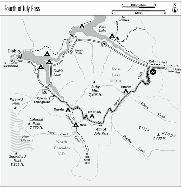
22 Fourth of July Pass
A day hike or short backpack that follows Panther Creek, then climbs over Fourth of July Pass to Thunder Creek, 9.7 miles overall.
Best season: Early July to early October.
Elevation gain: 2,190 feet, east to west.
Elevation loss: 2,850 feet, east to west.
Maximum elevation: 3,530 feet.
Topo maps: Crater Mountain, Ross Dam; Diablo Lake, Mount Logan.
Jurisdiction: Ross Lake National Recreation Area, North Cascades National Park.
Finding the trailhead: Park at the East Bank Trailhead at mile 138 on Washington Highway 20, and walk east on the highway for 60 yards to reach the beginning of the trail. The trek ends at the trailhead at the southern edge of Colonial Campground. Through-hikers will need to arrange a car shuttle.
The Hike
This popular trail offers an accessible overnight trek through the low pass behind Ruby Mountain. Heavy forests yield views of the surrounding grandeur grudgingly and at infrequent intervals. The trek along Panther Creek is a delight in itself, however, with foaming rapids and boisterous cascades, and perhaps the chance to spot a mink or a water ouzel. Travelers who hike this trail as a loop should post cars at both trailheads since hitchhiking can be a difficult proposition in this part of the country.
The trail leaves the highway in full sprint up the mountainside, zigzagging rapidly up the toe of a ridge. A long and wearying ascent carries hikers hundreds of feet above Panther Creek. After a brief traverse the path plummets through the timber to reach the streamside. Panther Creek courses through its narrow valley in a continuous series of rapids and cascades, rarely pausing to languish in a shady pool. The trail ascends the stream steadily, tracking its gradient and occasionally climbing onto steep hillsides to avoid a tricky impasse. Early on, the few brushy openings reveal no peaks but do give the nettles a chance to inflict pain on the unwary.
Just below the confluence of Stillwell and Panther Creeks, a footbridge spans the waters to carry the trail to an island camp in deep timber. The trail now follows the west bank of Panther Creek to an avalanche slope opposite the mouth of Stillwell Creek. From here, one can look eastward up the side valley to glimpse the stony pinnacles of Elija Ridge. From the upper edge of the clearing are views down Panther Creek of the lofty summit of Crater Mountain.
Tricouni Peak from Fourth of July camp
From this point on, the gradient of Panther Creek lessens, and peaceful hemlock woodlands line its banks. Occasional avalanche slopes interrupt the timber, but there are no views here. After 4.8 miles, the trail abandons Panther Creek and climbs westward along a finger ridge to begin the ascent to Fourth of July Pass. The lowland hemlocks are soon replaced by silver firs. Views are scarce as the path climbs steadily, then traverses southward to enter the pass. The drainage divide is a low and broad saddle, protected from prevailing winds. It fosters a rich and robust forest of hemlock that mirrors the forest community of the Panther Creek bottoms.
After passing through the gap, the trail climbs onto well-drained, stony slopes where Douglas fir and hemlock form a sparse woodland. A short spur path soon descends to an outcrop of gneiss that overlooks the Panther Potholes, a pair of small woodland lakes that are reputed to offer fine fishing for cutthroat trout to adventurous souls who survive the descent. Just beyond this point is Fourth of July Camp, which occupies an old burn grown up in young lodgepole pine and Douglas fir. The camp offers the best view of the trek, facing west toward Snowfield and Colonial Peaks with Neve Glacier between them. Farther south are Tricouni and Primus Peaks, framing Borealis Glacier.
After passing the camp, the trail begins its long and zigzagging descent into the Thunder Creek valley. After dropping through the timber for some distance, the path levels out and traverses northward. Openings in the forest reveal Snowfield Peak and the summit of Colonial Peak, as well as Davis Peak to the north. The trail soon resumes its descent, passing numerous openings in the timber. Elephant Butte is now visible to the north, and McMillan Spire flanks Davis Peak. At the bottom of the grade, the trail joins the Thunder Creek Trail between Neve and Thunder camps. Turn right to follow the flat bottomlands of Thunder Creek to Colonial Campground, where the hike ends at a marked trailhead.
Miles and Directions
0.0Trail leaves the highway just east of East Bank Trailhead.
1.5Top of initial grade. Trail begins descent to Panther Creek.
3.1Trail crosses Panther Creek to reach camping area.
6.5Fourth of July Pass.
7.2Fourth of July Pass Camp. Trail begins descent toward Thunder Creek.
9.7Trail ends at junction with Thunder Creek Trail, 2.1 miles south of Colonial Campground.