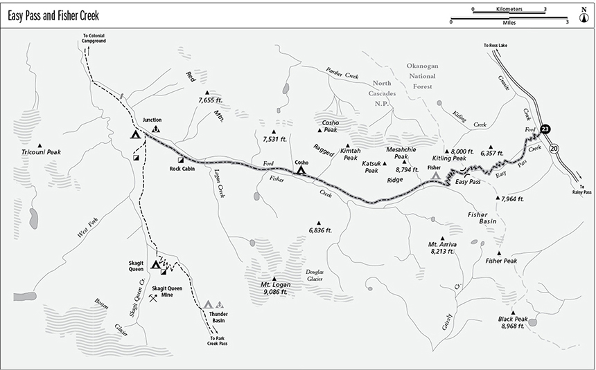
23 Easy Pass and Fisher Creek
A day hike to Easy Pass, 7.4 miles round-trip, or a backpack to the Thunder Creek Trail, 14.2 miles overall.
Best season: Late July to early October.
Elevation gain: 2,950 feet.
Elevation loss: 3,520 feet.
Maximum elevation: 6,540 feet at Easy Pass.
Topo maps: Mount Arriva, Mount Logan, Forbidden Peak; Diablo Lake, Mount Logan.
Jurisdiction: Okanogan National Forest, North Cascades National Park.
Finding the trailhead: The trailhead is at mile 151.5 on Washington Highway 20, 6 miles west of Rainy Pass.
The Hike
This route climbs from WA 20 over a high divide to enter the southern quadrant of North Cascades National Park. A day trip leads to the alpine country and mountain grandeur of Easy Pass, and backpackers can continue down Fisher Creek to intersect the Thunder Creek Trail for longer trips to Colonial Campground or Stehekin. Easy Pass is perhaps one of the best places in the Cascades to watch for mountain goats, and black bears commonly are spotted in the upper basin of Fisher Creek.
The trail begins with a crossing of Granite Creek, a knee-deep ford of swift-flowing water that will be necessary until a footlog is emplaced. On the far bank, the trail makes a few upward switchbacks through a sun-dappled forest of mountain hemlock to reach an open basin below Easy Pass. Stark and nameless crags guard the basin, and as the trail climbs upward, there are southward views of Mount Hardy. The trail crosses talus slopes, then zigzags up beside noisy waterfalls of Easy Pass Creek. Above the lower headwall is a hanging basin of alpine tundra and frost-shattered rock.
The path steepens as it zigzags up the talus to reach Easy Pass and the boundary of North Cascades National Park. Here, loose groves of subalpine larch and fir rise from the midst of broad heather meadows. Hikers get superb views of the Fisher Creek Basin, guarded by the massive granite summits of Fisher Peak at the head of the valley and Mount Arriva directly across the deep gulf of air. Descending from the pass, the trail traverses westward across a steep and flower-strewn mountainside interrupted by scattered clumps of fir. The westward views are outstanding here. The jagged horn of Mesahchie Peak presides over the north side of the valley, while Mount Logan rises in full view to the southwest, robed in the rumpled ice of Douglas Glacier. Looking farther down the valley, Tricouni Peak sends thin jawbones of naked rock above a thick cloak of glacial ice.
The trail zigzags down to the valley floor in short order, then follows the gentle downward flow of Fisher Creek through orderly subalpine meadows. Fisher Camp is soon reached, nestled into a narrow band of firs steeped in the mountain grandeur. The views continue unabated for a mile as the path makes its way down the valley. A mature forest closes in around the trail, which begins to descend in earnest. A brushy avalanche slope yields a final view of Mount Logan before the path disappears into the forest for good.
The slope levels off into a broad bottomland, shaded by a deep forest of silver fir and hemlock. Cosho Camp occupies a streamside site about 1.3 miles down the valley. Soon after passing the camp, the trail fords Fisher Creek, which has become a deep, lazy stream with translucent turquoise waters. As the path continues down the valley, avalanche slopes interrupt the forest on a periodic basis, revealing the summits of Ragged Ridge across the valley. A particularly broad brushfield at mile 10.6 has the best views of the peaks that crown the ridgetop.
Mountain hemlock and silver fir give way to western red cedar and western hemlock as the trail nears Logan Creek, and evidence of old rockfalls can be seen on both sides of the valley. Logan Creek itself sports a series of turbulent cascades over a channel of mossy boulders, providing an excellent place for rest and rejuvenation. As the trail continues onward, watch for the enormous rockslide scar on the south face of Ragged Ridge and the great pile of rubble at its foot. Soon after passing a foaming cascade on Fisher Creek, the path climbs into a maze of mossy boulders. It then leaves the streamside, descending steadily to reach its end at an intersection with the Thunder Creek Trail at Junction Camp.
Miles and Directions
0.0Trailhead on WA 20.
0.1Trail fords Granite Creek.
3.7Easy Pass. Trail enters North Cascades National Park and begins to descend.
4.7Trail bottoms out in Fisher Creek valley.
5.1Fisher Basin Camp.
8.6Cosho Camp.
9.1Trail fords Fisher Creek.
12.1Trail crosses Logan Creek.
12.9Trail passes Rock Cabin site.
14.1Junction with spur trail to Junction horse camp.
14.2Trail ends at junction with Thunder Creek Trail. Junction Camp (hikers only) is just to the south.