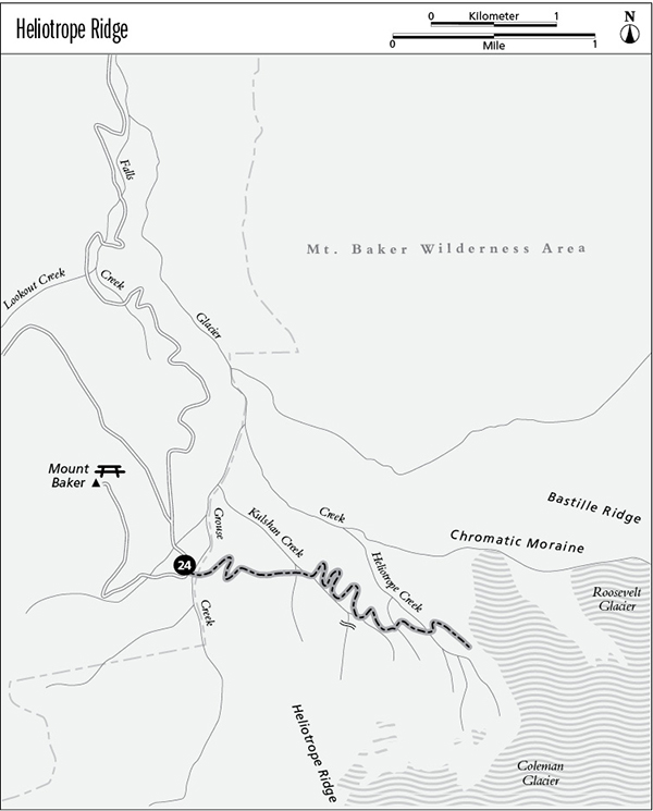
24 Heliotrope Ridge
A day hike to the edge of the Coleman Glacier on the lower flanks of Mount Baker, 5 miles round-trip.
Best season: Early July to mid-October.
Elevation gain: 2,560 feet.
Maximum elevation: 5,400 feet.
Topo maps: Mount Baker, Groat Mountain (trail not shown).
Jurisdiction: Mount Baker Wilderness (Mount Baker–Snoqualmie National Forest).
Finding the trailhead: Follow Highway 542 to the east end of Glacier, then turn right onto Glacier Creek Road (Forest Road 39). Follow this improved road, staying left at the junction with Forest Road 36, to reach the trailhead after 17 miles.
The Hike
Although named for a wildflower (the heliotrope, more commonly known as the Sitka valerian), this hike offers more in the wonders of rock and ice than alpine blossoms. It ascends through heavy forest to reach the alpine zone, ending at the edge of the Coleman Glacier for spectacular views of the icefalls and waterfalls that grace the regal flanks of Mount Baker. Climbers are often seen on the glaciers, but do not venture onto the ice without proper climbing gear and training, as hidden crevasses pose a potentially deadly threat to the unprepared.
The hike begins in an old-growth forest of hemlock, carpeted with clubmoss and the delicate blossoms of fairy bells. After a narrow footbridge spans the rushing waters of Grouse Creek, the path climbs steadily through the trees as it traverses eastward across heavily timbered slopes. The grade eases as the path crosses a finger ridge, but the climb picks up again as the trail approaches the next stream. Beside the watercourse, it begins to switchback straight up the mountainside. At the top of the climb, the path makes its way to the base of a delicate waterfall with narrow skeins of water tumbling across a sheer face of stone.
The path traverses east once more to reach the larger flow of Kulshan Creek. After a rock-hop across the stream, the trail adopts the finger ridge beyond it for a zigzagging ascent up toward the timberline. Passing several old camp spots, the path becomes more primitive and steepens with upward progress. The trees soon thin out, and brooks that occupy shallow avalanche chutes are lined with blossom-lit swards. Prominent among the wildflowers are the multiple white blooms of the Sitka valerian, blue lupines, yellow arnicas, and pink monkeyflowers.
Ultimately, the trail splits; avoid the climber’s trail and instead bear left on the path that leads ultimately to the glacier overlook. This trail traverses steep timberline meadows, yielding the first views of Mount Baker straight ahead. The path grows increasingly primitive as it makes tricky rock-hop crossings of several branches of Heliotrope Creek and climbs above the timberline. Bear for the lone outcrop of basalt that rises at the foot of a billowing lava flow draped with spectacular waterfalls. The hike ends atop this promontory, immediately overlooking the icefalls and crevasses of the Coleman Glacier. The great icy mound of the Roosevelt Glacier rises in the middle distance. Above, the jagged volcanic ribs of Mount Baker are draped with glacial ice in varying stages of a slow downward tumble.
Miles and Directions
0.0Trailhead.
0.1Footbridge over Grouse Creek. Trail enters Mount Baker Wilderness.
1.4Trail crosses Kulshan Creek.
1.7Campsite.
1.9Junction with climber’s trail to Coleman Glacier. Bear left.
2.3Several fords of Heliotrope Creek.
2.5Hike ends atop rocky promontory beside Coleman Glacier.
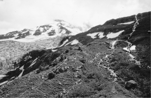
The Coleman Glacier and waterfalls on the flanks of Heliotrope Ridge