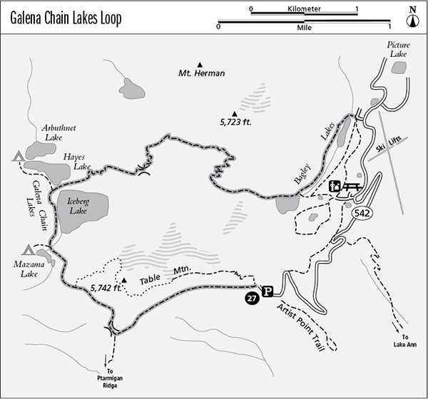
27 Galena Chain Lakes Loop
A day hike visiting the subalpine lakes of the Heather Meadows area, 6.7 miles one way or 7.7 miles as a loop hike.
Best season: Late July to mid-October.
Elevation gain: 880 feet clockwise.
Elevation loss: 1,740 feet clockwise.
Maximum elevation: 5,440 feet.
Topo maps: Shuksan Arm; Mount Shuksan.
Jurisdiction: Mount Baker Wilderness (Mount Baker–Snoqualmie National Forest).
Finding the trailhead: The hike begins at the west edge of the Artist Point parking lot, at the end of Washington Highway 542 (mile 57). It ends at the Lower Bagley parking lot, an unmarked, paved turnoff on the right side of the road just beyond the Picture Lake roundabout. Through-hikers will need to arrange a car shuttle or hike the Wild Goose Trail 1 mile back to the Artist Point Trailhead.
The Hike
This trail takes in the many lakes, meadows, and brooks of the Heather Meadows area. Although part of it passes through the Mount Baker Wilderness, do not come here seeking a wilderness experience: The trail is teeming with tourists, many of them unfamiliar with backcountry etiquette. There are camping spots near Mazama and Hayes Lakes, but because the area receives such a high volume of day hikers, it is hard to justify pitching a tent in the midst of the traffic.
The hike begins by following the path westward beneath the lava cliffs of Table Mountain. Open slopes reveal both Mount Shuksan and Mount Baker, as well as deep deposits of volcanic ash that have been exposed by waters that feed Swift Creek. A gentle uphill grade leads to a barren saddle, where the Ptarmigan Ridge Trail splits away and runs southward.
The Galena Chain Lakes Trail now turns northwest and descends steadily across the talus slopes at the foot of Table Mountain. It bottoms out in a meadowy pocket of mountain hemlocks. Here, the smallest of the chain lakes, Mazama Lake, is bordered by carpets of wildflowers. A spur path runs westward toward Mazama Falls, with campsites along the way. The main trail runs north through a wooded gap to reach Iceberg Lake, the largest of the Chain Lakes. This deep tarn is surrounded by hemlock parks lit with wildflowers, and it mirrors the tall cliffs that gird the northwestern flank of Table Mountain.
After skirting the western shore of Iceberg Lake, the trail reaches a narrow isthmus that separates it from Hayes Lake. A spur path runs north along Hayes Lake to reach camping spots beside Arbuthnet Lake. Each of the three northernmost lakes supports populations of brook trout. The main trail climbs across the hilly neck of land to the north of Iceberg Lake, then makes a steady ascent of the slopes beyond. Views open up as the trail climbs, featuring Ptarmigan Ridge, the summit of Mount Baker, and finally the deep blue waters of Iceberg Lake. Grassy pocket meadows give way to rocky country as the trail works its way upward, and soon the path leads through narrow corridors in the stone.
The trail then surmounts the narrow col below the northern corner of Table Mountain and continues to climb northward across the slopes of Mazama Dome. After a brief ascent, the trail begins the long and foot-pounding grade down to the Bagley Creek basin, in full view of Mount Shuksan. Heather slopes give way to a vast apron of broken rock that has fallen from Mazama Dome. Near the bottom of the grade, the trail reaches several brooks that are bordered by a fringe of pink monkeyflower. When in bloom, this bounty of blossoms attracts nectar-seeking hummingbirds.
The grade bottoms out at the marshy head of upper Bagley Lake, and a faint pathway departs to the right to round the head of the lake. The main trail runs north to the foot of the lake, where a stone footbridge leads toward the visitor center and connects with the Wild Goose and Bagley Lakes Trails (turn right for a shorter loop). Our route continues to follow the western edge of the valley, becoming rougher as it rounds the shore of lower Bagley Lake. Goat Mountain is the prominent summit to the north. The trail finally crosses the dam at the foot of the lower lake to reach an extensive parking lot that marks the lower trailhead.

Miles and Directions
0.0Artist Point parking area.
0.3Trail enters Mount Baker Wilderness.
1.2Junction with Ptarmigan Ridge Trail. Bear right for Galena Chain Lakes.
2.1Mazama Lake.
2.4Trail reaches foot of Iceberg Lake.
2.7Junction with trail to Arbuthnet Lake. Bear right to complete the loop.
3.7Trail crosses pass to enter Bagley Creek watershed and leaves Mount Baker Wilderness.
5.4Head of upper Bagley Lake.
5.8Junction with spur trail to visitor center. Stay left to complete the hike.
6.3Head of lower Bagley Lake.
6.6Trail crosses dam at foot of lower Bagley Lake.
6.7Lower trailhead.