
28 Ptarmigan Ridge
A day hike from the Artist Point Trailhead to Sholes Glacier, 11.8 miles round-trip.
Best season: Early August to mid-October. Ice axe recommended.
Elevation gain: 1,470 feet.
Elevation loss: 495 feet.
Maximum elevation: 6,160 feet.
Topo maps: Mount Baker, Shuksan Arm; Mount Shuksan.
Jurisdiction: Mount Baker Wilderness (Mount Baker–Snoqualmie National Forest).
Finding the trailhead: The hike begins on the Chain Lakes Loop Trail, which starts at the west edge of the Artist Point parking lot, at the end of State Highway 542 (mile 57).
The Hike
This trail follows a barren ridgetop through the high alpine country that leads upward to the glaciers of Mount Baker. For a modest day hike, the trek gives a real feeling of a high mountain traverse across country that is ordinarily the domain of mountaineers. There are several potential campsites near the end of the trail, but the heavy volume of day use in the area makes solitude a rare commodity.
The trek begins on the Galena Chain Lakes loop, which runs westward from the parking lot across the open skirts of Table Mountain. Hikers get superb views of Mounts Shuksan and Baker as the trail makes its way to the barren saddle at the head of Wells Creek. It is here that the Ptarmigan Ridge Trail departs south, descending into a barren and rocky basin. The fields of snow and shattered stone appear lifeless at first, but closer inspection reveals tiny mats of saxifrage on drier spots and vigorous clumps of pink monkeyflower along watercourses. The trail descends across the rolling washes of the basin, then makes a steady ascent to a saddle on the crest of Ptarmigan Ridge.
The vegetation is more vigorous on the ridgetop and on the southeast-facing slopes beyond it, forming fragile heather meadows and copses of mountain hemlock. The sharp spire of Coleman Pinnacle rises ahead along the ridgeline. The trail traverses beneath its eastern face, climbing gently across snowfields and talus slopes. It reaches a superb overlook south of the pinnacle. From here, excellent views stretch westward, featuring the regal crest of Mount Shuksan with a collection of lesser-known summits south of it: stout Mount Blum, the jagged teeth of Hagan Mountain guarding its broad glacier, and Mount Bacon farthest south. To the east is the towering summit of Mount Baker, and pouring down its flanks are Park and Rainbow Glaciers, separated by the snaggletooth spires of the Lava Divide. Below the overlook is Camp Kaiser, perched on a pair of high knolls on the rim of Avalanche Gorge.
Most hikers turn around here, but the trail continues northward across dense sedge meadows on the back side of Coleman Pinnacle. Lupine, bistort, and aster provide the trail’s finest floral displays. Nearing the next saddle, the path descends through wind-torn firs and crosses a small rill to reach eroded slopes beyond. After working its way around the head of the basin, the faint track now climbs westward toward a dark and jagged ridge of rhyolite. The billowy icefields of Sholes Glacier lie ahead as the path climbs through a volcanic moonscape. Even here, hardy plants such as dwarf fireweed and silky phaecelia have taken root amid the fractured lava. The trail ends as a definable entity at the edge of Sholes Glacier; ahead lies a mountaineer’s route to Mount Baker.
Miles and Directions
0.0Artist Point parking area. Follow Galena Chain Lakes Trail.
0.3Trail enters Mount Baker Wilderness.
1.2Ptarmigan Ridge Trail splits away from Chain Lakes Trail. Turn left.
2.4Trail reaches pass at the head of Wells Creek drainage.
4.3Overlook above Camp Kaiser.
4.7Saddle behind Coleman Pinnacle.
5.9Trail peters out beside Sholes Glacier.
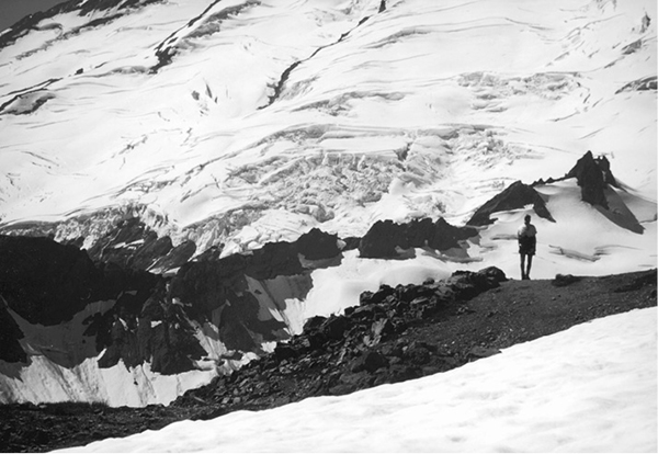
Viewing the Rainbow Glacier from Ptarmigan Ridge