Lake Ann and Mount Shuksan
29 Lake Ann
A day hike to Lake Ann, 7.4 miles round-trip, or to the toe of Curtis Glacier, 9.4 miles round-trip.
Best season: Late July to mid-October.
Elevation gain: 1,540 feet.
Elevation loss: 1,200 feet.
Maximum elevation: 5,200 feet near Curtis Glacier.
Topo maps: Shuksan Arm; Mount Shuksan.
Jurisdiction: Mount Baker Wilderness (Mount Baker–Snoqualmie National Forest), North Cascades National Park.
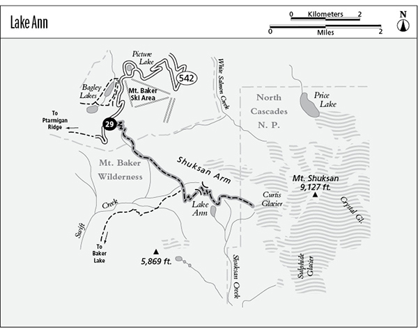
Finding the trailhead: From the town of Glacier, drive east on Highway 542, past Picture Lake to mile 56, where a paved parking area on the left side of the road announces the beginning of the Lake Ann Trail.
The Hike
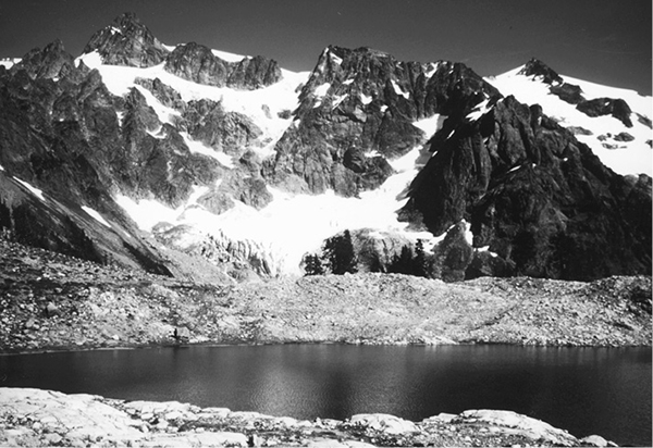
Lake Ann is one of the truly awe-inspiring destinations in the North Cascades, with the soaring towers of Mount Shuksan rising above it and the crevasse-riddled surface of Curtis Glacier just across a small valley. The lake itself makes a fine day hike; from its shore adventurous travelers can traverse the head of Shuksan Creek on a primitive climber’s trail to reach the glacier’s toe. There are a few campsites among the copses of mountain hemlock above the eastern shore, but they fill up quickly at the height of the summer season.
The trail begins with a steady descent into the head of a hanging valley. Widely spaced mountain hemlocks rise from a dense growth of huckleberry bushes. Folds in the hillsides bear dry streamcourses that are crowded with alpine flowers. At the bottom of the initial grade is a beautiful subalpine basin where sedge meadows are lit by the lavender blossoms of spiraea. The piping of marmots and the bleats of pikas rise from talus slopes on both sides of the basin. In late August the blueberries ripen, offering good pickings as the trail continues down the valley beneath the brooding walls of Shuksan Arm. Small but snowy summits rise ahead, and Mount Shuksan itself is revealed as the trail crosses a second clearing that is slowly being colonized by conifers.
Lake Ann and Mount Shuksan
At the lower end of this opening, the path crosses the nascent waters of Swift Creek and begins a level traverse across slopes forested in silver fir and hemlock. Mount Baker can be glimpsed through the treetops, and it emerges into full view as the path descends gently into an open bowl. A signpost on the floor of the bowl marks the intersection with the primitive Swift Creek Trail, which is no longer maintained by the Forest Service.
The Lake Ann Trail is the well-beaten track that ascends the far side of the basin. A vigorous grade leads upward through alpine meadows and heather to reach a gap in the ridgetop. Mount Shuksan cannot be seen from the pass, but Mount Baker is in full view to the west.
The trail now makes its shallow descent to the foot of Lake Ann, which commands a jaw-dropping view of the west face of Shuksan. The peak presents a dynamic and ever-changing landscape, with huge chunks of ice periodically breaking away from the lobes of Curtis Glacier, and slender waterfalls dropping down the lower flanks of the mountain into the depths of the Shuksan Creek valley. Lake Ann itself occupies a shallow and barren pocket near the ridgetop, and hardy saxifrage blooms amid the outcrops and boulders surrounding the water. A handful of campsites are huddled amid mountain hemlocks at the eastern edge of the lake, perched high above Shuksan Creek. A climber’s access trail traverses around the headwall of Shuksan Creek, entering North Cascades National Park on its way to Curtis Glacier.
Miles and Directions
0.0Lake Ann Trailhead.
0.8Trail reaches upper basin of Swift Creek and enters Mount Baker Wilderness.
1.4Trail crosses Swift Creek.
2.2Junction with Swift Creek Trail. Stay left as Lake Ann Trail starts to climb.
3.5Trail crosses a pass to enter the Shuksan Creek drainage.
3.7Lake Ann Trail becomes a primitive climber’s path.
4.5Path enters North Cascades National Park.
4.7Trail reaches lower end of Curtis Glacier.