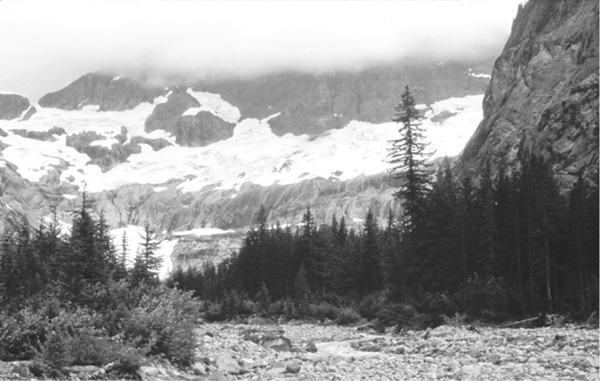
View of the Nooksack Circque
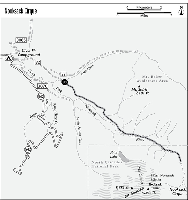
30 Nooksack Cirque
A short backpack along a wilderness route involving gravel bar hiking and multiple river fords, 5.7 miles one way.
Best season: Mid-July to mid-October.
Elevation gain: 979 feet.
Elevation loss: 35 feet.
Maximum elevation: 3,100 feet.
Topo maps: Mount Larrabee, Mount Sefrit, Mount Shuksan.
Jurisdiction: Mount Baker Wilderness (Mount Baker–Snoqualmie National Forest).
Finding the trailhead: From Glacier, drive east on Washington Highway 542 for 13 miles to mile 46.5. Turn left onto Forest Road 32, and after a mile bear right at the split on Forest Road 3400, following signs for Nooksack Cirque. A narrow and sometimes bumpy gravel road leads the last mile to the trailhead.
The Hike
This hike begins on an easy trail wandering along the forested floor of the Nooksack River valley, but the easy hiking ends after 3.6 miles as the trail gives out and further travel is up the gravelly bed of the river. Numerous fords are required to sustain upstream progress, but the reward is a spectacular view of the craggy summits and glaciers that grace the flanks of Mount Shuksan. Backpackers can find primitive sites in the forest near the end of the trail, or pitch a tent on a gravel bar along the river. Near the head of the valley, the route enters North Cascades National Park. Backcountry permits are required to camp within the park, and pets are not allowed there.
The trip begins with a crossing of Ruth Creek. A logjam crossing may be possible; otherwise, a knee-deep ford will be required to start the trip. On the far bank, the trail adopts an abandoned roadbed, which tunnels through a shady young forest of red cedar and hemlock. The traveling is fairly level at first, but after a mile the track begins a moderate climb. The dense thicket of trees yields no views of the river and only scant glimpses of the steep peaks that surround its valley. After 2 miles, the old roadbed descends toward the river bottoms, and soon a footlog spans a substantial creek. Look up at this point to view the rocky heights of Mount Sefrit.
The old road continues upstream and soon becomes a footpath to enter the Mount Baker Wilderness. The change in the forest is remarkable here: The young, dense stands that grew in the wake of logging are now replaced by old-growth hemlocks, widely spaced and with an understory of blueberries, salmonberries, and devil’s club. There are numerous large, old snags, their dead pillars of wood providing feeding and nesting habitat for cavity-nesting birds. The periodic collapse of a towering giant has created openings in the forest canopy, allowing sunlight to filter down to the forest floor and nourish a fresh crop of seedlings. The footpath wanders at will among the trunks of the tall trees, and soon it approaches the riverbank. A cluster of campsites among the trees signals the end of the established trail.
View of the Nooksack Circque
From this point on, the hike is a rough-and-tumble scramble up the boulder-choked course of the Nooksack River. Upstream, Icy Peak rises with its mantle of glacial ice. Choose your own route up the gravel bars; the easiest path will change from season to season as the brawling waters of the Nooksack are constantly at work resculpting their own channels. Expect to encounter many obstacles: fallen trees, ford crossings of the braided channels of the river wandering from bank to bank (and sometimes into the neighboring forest), and brush woodlands to either side. The easiest path to upstream progress is to resign yourself to soggy feet and make channel crossings as needed on your way up the gravel bars. Alternately, you may seek out game trails through the forest to bypass an encroaching channel. The glacier-fed waters are icy cold but only knee deep on a typical late-summer day.
The North Fork of the Nooksack is typical of geologically young rivers, with a steep gradient and a bed of loose boulders and gravel. The water is constantly pushing up new barriers to its own flow, then seeking lower ground to make its way around the new obstacles. The result is a braided channel, where the river often splits into multiple courses that wander seemingly at random across a broad and gravelly outwash plain.
Traveling upstream, the coniferous forest that robes the mountainsides is soon interrupted by avalanche chutes, and before long the trees are limited to narrow stringers along the riverbank and in a few protected spots along the valley wall. The route enters North Cascades National Park as the valley makes its great bend to the south, and Seahpo Peak and Jagged Ridge are revealed in all their glory at the head of the valley, with the East Nooksack Glacier draped between them like an apron. To the west, a steep wall is graced with slender waterfalls that descend from the West Nooksack Glacier, invisible above the rocky palisade. It is possible to hike all the way up into the Nooksack Cirque proper, although the river channel narrows and the riverbanks become choked with brush. Hikers who make it through the gauntlet will emerge in a rotunda of stone, draped with delicate waterfalls that descend from the glaciers above.
Miles and Directions
0.0Trailhead. Seek a logjam crossing of Ruth Creek.
3.0Footlog crosses a nameless creek at the foot of Mount Sefrit.
3.2Trail enters Mount Baker Wilderness.
3.6Trail ends as such. Hike up gravelly bed of Nooksack River.
5.7Narrowing river channel and brushy valley floor make further travel onerous. Hike ends here.