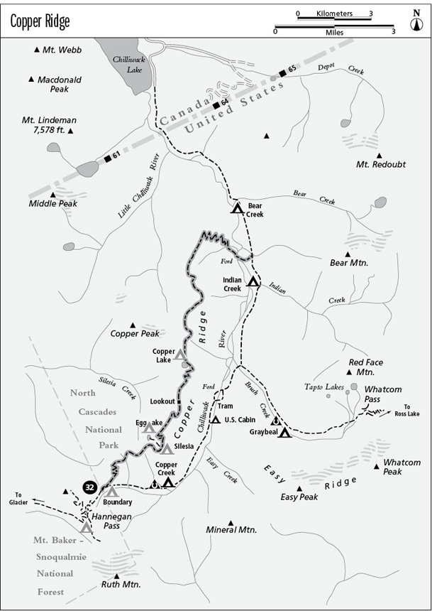
32 Copper Ridge
A backpack from the Hannegan Pass Trailhead to Egg Lake (8.5 miles one way) or Copper Lake (11.4 miles one way), or an extended trip from Boundary Camp to the Chilliwack River, 13.9 miles overall.
Best season: Late July to mid-October.
Elevation gain: 2,820 feet (south to north).
Elevation loss: 4,930 feet (south to north).
Maximum elevation: 6,260 feet at Copper Ridge Lookout.
Topo maps: Mount Sefrit, Copper Mountain; Mount Shuksan, Mount Challenger.
Jurisdiction: North Cascades National Park.
Finding the trailhead: The trail begins at Boundary Camp, which can be reached by a 5-mile hike over Hannegan Pass. The end of the trail is accessed by a 6.9-mile hike up the Chilliwack River or a 16-mile jaunt over Hannegan Pass.
The Hike
This trail follows an alpine ridge through the northwest corner of the North Cascades. Since it lies entirely within the national park, permits are required and all park regulations apply. This is one of the few trails in the North Cascades that stays above timberline for a significant distance, and along its length are superb mountain views, abundant wildlife, and a diverse array of alpine flowers. Silesia Camp and Egg Lake can be reached in a long two-day backpack over Hannegan Pass. Destinations farther north along Copper Ridge require a multiday expedition.
From the signpost in the meadows above Boundary Camp, the Copper Ridge trek begins with an eastward traverse into heavy timber. Level stretches alternate with spurts of climbing, and soon the trail is high above the valley floor. The dense forest of mountain hemlocks thins out as the trail rises higher, revealing views of Ruth Mountain and Mineral Peak. A series of switchbacks lead up toward the ridge crest, and at the top of the grade the trail crosses a steep and eroded gully known as Hells Gorge. Lingering snowdrifts in this area make for a hazardous crossing until midsummer.
The trail crosses several steep meadows before climbing into the heather-blueberry parklands of the ridgetop. The path crests the ridgeline at an open saddle, and hikers can look north across the headwaters of Silesia Creek, with fine views of Copper Mountain beyond the forested basin. As the trail follows the top of Copper Ridge, there are excellent views of Ruth Mountain and Mineral Peak across the Chilliwack valley, while the craggy summit of Mount Shuksan rises above Nooksack Ridge to the southwest. Due south, the sharp horn of Mount Blum is visible through Chilliwack Pass.
After climbing vigorously to surmount several low summits, the trail reaches Silesia Camp. Here, tent sites are perched on a high knoll overlooking the Chilliwack valley. Looking down the valley, hikers can now see the summits of Bear Mountain and Mount Redoubt. In the next low saddle, a spur path descends northward to reach the shore of Egg Lake. This aquamarine tarn is cupped in a rocky hollow high above Silesia Creek. The main trail rounds the next high point to another saddle, then begins the final, calf-burning climb to Copper Ridge Lookout, which is staffed throughout the summer. The lookout occupies the highest point on the trail, commanding views in all directions. The structure itself is not open to the public. Scan the surrounding fellfields for marmots and white-tailed ptarmigan.
The trail then descends along the ridgeline beyond the lookout, skirting perennial snowdrifts as it descends. A barren moonscape of broken granite awaits in the next saddle, overlooked by brooding summits that stretch northward to Copper Mountain itself.
The trail next drops onto east-facing slopes, snaking downward at a vigorous pace toward the foot of Copper Lake. Along the way, several spots offer excellent aerial perspectives on the lake, with its deep azure waters embracing a single rocky peninsula. The lake basin was scooped out of the granite by a small hanging glacier during the most recent ice age. The camp spur leads to the lakeshore, where copses of mountain hemlock rise from the basin’s heather-covered terminal moraine. Pikas live in the boulder fields around the lake, and their antics are on display for nature watchers who have the requisite patience.
The main trail angles downward across the lake’s outlet stream, then ascends gradually through open parks where mountain brooks tumble down through boulder-strewn meadows. A vigorous climb then leads upward through the timber to reach the bare top of a finger ridge. Superb views across the Chilliwack Valley are punctuated by the soaring summits of Mount Redoubt and Bear Mountain, as well as the multiple peaks of Red Mountain, gathered around the headwaters of Indian Creek. After dropping through an open bowl of heather-blueberry meadows, the trail traverses steep slopes upholstered with herbaceous wildflowers. It soon reaches a north-facing viewpoint, which takes in the cluster of sharp horn peaks west of Chilliwack Lake.
The trail then drops to negotiate a snow-covered talus slope. After a tricky crossing, it traverses above more slopes of broken rock to reach a spot below a wooded saddle. From here, the route leads steeply downward onto timbered slopes, descending on a northward tangent through a climax forest of hemlock. It soon passes through the edges of an old burn. Here, a growth of young Alaska cedar and hemlock is striving to fill the gap. Hikers get parting views of Bear and Red Face Mountains as the path drops steeply across the burn. Beyond it is the first in a long series of switchbacks that leads to the valley floor, descending through monotonous forest at a modest pace.
Near the bottom of the grade, the trail strikes a woodland stream and follows it downward into the diverse forest of the Chilliwack bottomlands. The trail soon crosses the streamcourse, then runs south along the base of the ridge to a ford of the river channels. Travelers who make the thigh-deep crossing in mid-August will find spawning salmon in their path. The trail is faint where it crosses an alder grove between the channels but becomes distinct again on the far side of the water. It follows the bank upstream for a short distance, then turns inland to meet the Chilliwack River Trail just north of Indian Creek Camp.
Miles and Directions
0.0Trail begins at Boundary Camp. Junction with Hannegan Pass and Chilliwack River Trails.
1.7Trail crosses upper Hells Gorge.
1.9Spine of Copper Ridge.
3.0Silesia Camp.
3.2Junction with spur trail to Egg Lake Camp (0.3 mile, moderate). Bear right.
5.2Copper Ridge Lookout.
6.4Copper Lake. Junction with spur trail to Copper Lake Camp. Bear right.
11.0Trail enters old burn and begins long descent into Chilliwack Valley.
13.6Chilliwack River ford.
13.9Junction with Chilliwack River Trail.