
Nurse log in the Chilliwack valley
33 Chilliwack River
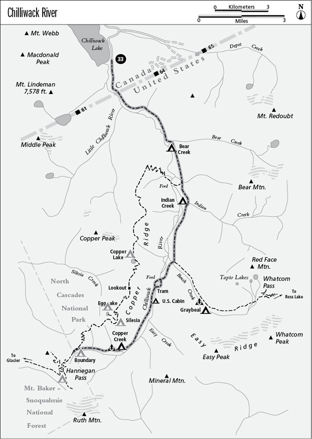
A backpack following the Chilliwack River from Chilliwack Lake in Canada to Boundary Camp in North Cascades National Park, 17.9 miles overall.
Best season: Mid-June to mid-October.
Elevation gain: 3,440 feet (north to south).
Elevation loss: 1,016 feet (north to south).
Maximum elevation: 4,450 feet at Boundary Camp.
Topo maps: Copper Mountain, Mount Sefrit, Skagit River-CGS; Mount Shuksan, Mount Challenger.
Jurisdiction: British Columbia Ministry of Forests, North Cascades National Park.
Finding the trailhead: From Chilliwack, British Columbia, take Vedder Road south to the edge of town. Turn left before crossing the bridge over the Chilliwack River, following signs for Chilliwack Lake Provincial Park. The road is paved for the first 32 km (20 miles), then turns to gravel for the final 13 km (8 miles). At Chilliwack Lake Provincial Park, bear left onto Chilliwack River Forest Road, a narrow and potholed road that follows the lakeshore. Park at the barrier at the head of the lake and follow the closed road to the marked trailhead.
The Hike
This remote valley-bottom trek wanders among some of the finest stands of old-growth timber that remain in the Pacific Northwest. Local wags note with wry humor that “It always rains in the Chilliwack,” and the abundance of rainfall gives the ancient forest the ambience of the temperate rain forests of coastal Washington and British Columbia. Due to recent fears of terrorists infiltrating across the international border, access from Chilliwack Lake on the Canadian side has become difficult; check with Customs authorities before planning your trip. As a result, the lower end of the trail has become neglected, and now parts of it may be quite brushy. The trail is more commonly accessed from the south via Hannegan Pass and often is hiked as part of a longer extended journey through the northwestern reaches of North Cascades National Park.
From the Canadian trailhead on the south shore of Chilliwack Lake, follow the closed road past the lakeshore campsites to reach a post marked Upper Chilliwack Trail. Turn left as the rough and often muddy pathway meanders through old-growth cedar and brushy clearings. The trail skirts the estuary where the river enters Chilliwack Lake, a beautiful 6-mile-long mere guarded by lofty peaks. The estuary is a rare mountain wetland where waterfowl and aquatic mammals thrive. The woodland that surrounds the mouth of the river has many of the hallmarks of a rain forest: vine maples draped with club moss, seedlings growing from arboreal perches atop nurse logs and decaying stumps, and tree frogs singing from the branches at night.
The international border is marked by an arrow-straight swath cut through the timber, long since overgrown by dense brush. North Cascades National Park begins at the far side of the opening. The path now makes frequent visits to the riverbank, where the crystalline waters of the Chilliwack glide through a sandy course strewn with driftwood. Chilliwack Camp occupies a riverside site at mile 2.7, and already the forest has begun to take on a younger aspect. The rich soils of the bottomland support a riot of undergrowth, and the trail often forces its way through dense thickets.
After several miles, the trail climbs out of the bottoms for the first time, emerging into a mossy forest where a few ancient Douglas firs tower above their younger neighbors. The next little climb supports a stand of even larger western red cedars, with some of the boles exceeding 10 feet in diameter. Just beyond this impressive stand, snowslides have cleared a broad path through the forest. The brush is tall, however, and it is difficult to gain views of the surrounding mountains.
The trail soon returns to the bottomland forest, and the underbrush disappears almost entirely. Upon crossing Bear Creek, the trail skirts a sandbar that offers the first river views in many miles. There is a small camp on the far bank. The trail turns inland again, climbing toward the steep slopes that bound the valley. Reaching them, the path turns southward once more. Cedars and hemlocks dominate the mossy woodland, but the few ancient Douglas firs that overtop them are most striking. A well-marked junction announces the northern terminus of the Copper Ridge Trail. A short detour down this trail leads to the banks of the river, where spawning salmon may be viewed during mid-August.
Nurse log in the Chilliwack valley
Meanwhile, the Chilliwack River Trail continues southward to Indian Creek Camp and the suspension bridge that spans this substantial stream. The forest is now grading into a montane stand dominated by silver fir, a deep-shade specialist. The path skirts sloughs where beavers once dammed side channels of the river; they have since become choked with thickets of willow. The mossy forest is ultimately broken by a broad and brushy slope, and beyond this clearing the silver firs are replaced by hemlocks that thrive on a warmer southwesterly exposure.
The path then descends to Brush Creek, where the Whatcom Pass Trail runs eastward toward the shores of Ross Lake. After a bridge spans Brush Creek, the trail continues southward through the forest, dipping and rising across the lower slopes of the foothills. It crosses several substantial brushfields, courtesy of avalanches that routinely course down the toe of Easy Ridge during winter. The trail soon splits, the lower trail bound for a ford of the river while the upper trail accesses an aerial tram that carries hikers high above the water. In midstream, look south for the first views of Ruth Mountain. The trails rejoin on the far bank, and the trail continues south into a broad clearing for superb views of Mineral Mountain ahead and Bear Mountain down your back trail.
Just beyond this opening, trails run down into the bottoms to reach the U.S. Cabin camps. These camps are sited within damp riverside stands of hemlock that receive little sunlight and are always a bit gloomy. In camp, look for nurse logs that form seedbeds for young saplings, colonnades of mature trees that originated atop such decaying logs, and stilted trees that got their starts atop rotting stumps.
The main trail continues up the valley, through a young but mossy forest that offers a few openings for mountain views. A spur path descends to the river opposite Easy Creek, while the main trail surmounts a low shoulder of Copper Ridge. The path then descends gradually to the valley floor, where boggy forests are underlain by a sparse growth of salmonberry and devil’s club. The trail passes the two Copper Creek camps on either bank of that small stream, then begins a vigorous ascent toward Hannegan Pass. It climbs through an open woodland of Douglas fir that bears the mark of low-intensity fire; huckleberries grow abundantly in the understory. The canopy opens at the mouth of Hells Gorge, where small waterfalls tumble down across sills in the eroded rock.
After more hard climbing, the trail enters a forest of mountain hemlock and levels off. A small clearing that bears a trickle of water affords eastward views of Easy and Whatcom Peaks above a shoulder of Mineral Peak. The path soon enters the flowery meadows below Hannegan Pass and reaches its terminus at a trail junction above Boundary Camp. From here, hikers can take the Copper Ridge Trail to the north, or continue southward into national forest land on the Hannegan Pass Trail.
Miles and Directions
0.0Trail begins at head of Chilliwack Lake.
1.7Trail crosses U.S.–Canada border to enter North Cascades National Park.
2.7Chilliwack Camp.
5.1Trail crosses Bear Creek to arrive at Bear Creek Camp.
6.9Junction with Copper Ridge Trail. Keep going straight ahead.
7.4Indian Creek Camp.
7.5Bridge over Indian Creek.
10.2Junction with Whatcom Pass Trail. Bear right for Hannegan Pass.
10.3Trail crosses Brush Creek.
11.0Junction with horse ford trail. Bear left for aerial tram over river.
11.2Aerial tram spans Chilliwack River. Trail now follows west bank.
11.3Horse ford trail rejoins hiker route. Bear left.
12.1Spur trail descends to U.S. Cabin hiker camp.
12.3Spur trail descends to U.S. Cabin horse camp.
15.4Copper Creek. Hiker camp on north bank; horse camp on south bank.
16.7Trail crosses mouth of Hells Gorge.
17.9Trail ends at Boundary Camp. Junctions with trails to Hannegan Pass and Copper Ridge.