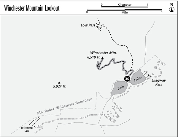
36 Winchester Mountain Lookout
A short day hike from Twin Lakes to the top of Winchester Mountain, 3.8 miles round-trip.
Best season: Late July to early October.
Elevation gain: 1,310 feet.
Maximum elevation: 6,510 feet.
Topo maps: Mount Larrabee; Mount Shuksan.
Jurisdiction: Mount Baker Wilderness (Mount Baker–Snoqualmie National Forest).
Finding the trailhead: From Glacier, drive east on Highway 542 to mile 46, where a major gravel road (Forest Road 3065) branches away beside a highway maintenance compound. Follow this road 4.5 miles to the Gold Run Pass Trailhead. Visitors with four-wheel drive can continue up the road for the remaining 4.5 miles to reach Twin Lakes; otherwise, walk the road. The trail begins at the trailhead between the two lakes.
The Hike
This short trail climbs from Twin Lakes to the summit of Winchester Mountain, where a historic fire lookout is now maintained for overnight stays. There is no way to reserve the cabin except by getting there early; overnight visitors should bring a tent in case the lookout is occupied. Accessing the trailhead requires four-wheel drive; visitors who wish to save wear and tear on their vehicles can hike the road for 4.5 miles from the Tomyhoi Lake trailhead.
The trail begins by zigzagging up through flowery meadows above the sapphire waters of Upper Twin Lake. The earliest mountain vistas feature the bare knuckles of the Skagit Range, rising to the north beyond the West Fork of Silesia Creek. A lesser pathway that leads to High Pass soon splits away to the right, while the main trail continues upward across a series of meadowy terraces bordered by tall mountain hemlocks. The stark and snow-dappled peaks to the south belong to Goat Mountain, and soon the taller summit of Mount Shuksan can be seen between them. Look southwest down the valley of Swamp Creek for an unobstructed view of Mount Baker.
The trees fall away as the path gains elevation, and soon both of the Twin Lakes can be seen, as well as the mining road that leads northward from their shores toward the Lone Jack Mine. Upon approaching the northern corner of the mountain, the trail offers an early look at Mount Larrabee and the stone towers of The Pleiades. The trail then levels off and traverses over to the south side of the mountain, where it seems to end at an exposed buttress of stone. A steep and treacherous scramble leads over the spur, whereupon the trail swings west to begin a circuit of the summit.
Bushlike krummholz of hemlock and subalpine fir flanks the trail as it climbs steadily. Hardy alpine flowers bloom from every crevice in the rock as the trail reveals Tomyhoi Peak, crowding the lake of the same name. Upon reaching west-facing slopes, hikers face a surreal panorama of vertical rock ahead, with the stone pyramid of Mount Larrabee flanked to the left by the twisted spires of the Border Peaks and to the right by the razorback ridges of The Pleiades. An old fire lookout awaits at the end of the climb, built during the 1930s and now relegated to the role of a shelter for hikers. Views stretch to the distant horizons, encompassing the Picket Range to the west, Mount Redoubt to the northwest, and a sea of remote crags in the heart of the Canadian Cascades to the north.
Miles and Directions
0.0Twin Lakes Trailhead.
0.2Junction with High Pass Trail. Turn left.
1.9Winchester Mountain Lookout.

Goat Mountain and Twin Lakes from Winchester Mountain