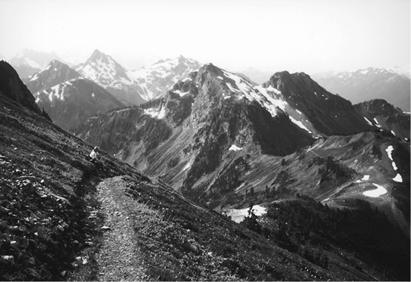
Looking south from the slopes of Mount Larrabee
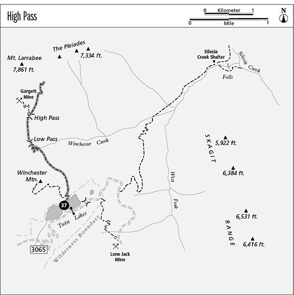
37 High Pass
A day hike from Twin Lakes to The Pleiades overlook, 8 miles round-trip.
Best season: Late July to early October.
Elevation gain: 1,845 feet.
Elevation loss: 305 feet.
Maximum elevation: 6,740 feet at trail’s end.
Topo maps: Mount Larrabee; Mount Shuksan.
Jurisdiction: Mount Baker Wilderness (Mount Baker–Snoqualmie National Forest).
Finding the trailhead: From Glacier, drive east on Highway 542 to mile 46, where a major gravel road (Forest Road 3065) branches away beside a highway maintenance compound. Follow this road 4.5 miles to the Gold Run Pass Trailhead. Visitors with four-wheel drive can continue up the road for the remaining 4.5 miles to reach Twin Lakes; otherwise, walk the road. The trail begins at the trailhead between the two lakes.
The Hike
This trail makes a challenging half-day hike from Twin Lakes; travelers who cannot drive all the way to the trailhead will have difficulty completing the trek in a single day. On the way to its terminus high on the flanks of Mount Larrabee, the trail passes the old Gargett Mine, which was worked unsuccessfully for gold during the early 1900s.
The path begins by ascending flower-strewn slopes above Upper Twin Lake. It soon splits away from the larger Winchester Mountain Trail and runs north to cross the low divide that leads into the Winchester Creek watershed. The pyramid-shaped summit that rises ahead is Mount Larrabee, streaked with a rusty red from the oxidizing iron in its bedrock. This summit will be a constant companion as the trail makes its way northward.
Looking south from the slopes of Mount Larrabee
The trail now descends steeply across slopes that offer the best floral displays of the hike. Still high above the valley’s head, the path levels off and traverses beneath the rocky eastern slopes of Winchester Mountain. Fine eastward views feature the naked domes of the Skagit Range as well as the sharp horn peaks that rise beyond the Canadian border. The trail ultimately reaches the bottom of a wide and heathery couloir and switchbacks up it to gain the meadowy col of Low Pass. Looking westward, hikers get good views of Tomyhoi Peak, and Mount Baker becomes visible as the path climbs the rocky knoll to the north.
After a brief but vigorous ascent, the trail rounds the knob to reach the long and lofty saddle of High Pass. Examine the northern slopes of the basin below to view the rusting wreckage of the Gargett Mine. For visitors who would like a closer look, a good trail descends into the basin then climbs briefly to reach the mine site. Do not damage or remove any part of this historical site; it is protected by federal law.
From High Pass, the main trail gets rougher as it climbs steeply up the ridgeline toward the base of Mount Larrabee. Southward views open up as the path gains altitude, revealing a sea of sharp horn peaks: Winchester Mountain, Goat Mountain, Mount Sefrit, and finally the lofty crest of Mount Shuksan. After a few switchbacks across bare and unstable scree, the path ascends across the heather to a high and barren col that overlooks the jagged spires of The Pleiades. Run the ridgetops southward for panoramic vistas that encompass such distant peaks as Mount Redoubt to the east and those of the Picket Range to the southeast.
Miles and Directions
0.0Twin Lakes Trailhead.
0.2Junction with Winchester Mountain Trail. Turn right.
2.1Low Pass.
3.0High Pass. Junction with Gargett Mine spur (0.3 mile, moderate). Keep right to complete the trek.
4.0Trail ends at overlook of The Pleiades.