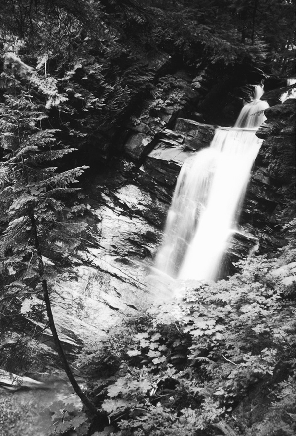
Falls below the Silesia Creek shelter
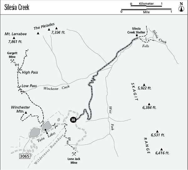
38 Silesia Creek
A long day hike or short backpack from Twin Lakes to the Silesia Creek Shelter, 13 miles round-trip.
Best season: Mid-July to mid-October.
Elevation gain: None.
Elevation loss: 2,620 feet.
Maximum elevation: 5,240 feet at Skagway Pass.
Topo maps: Mount Larrabee, Mount Sefrit; Mount Shuksan.
Jurisdiction: Mount Baker Wilderness (Mount Baker–Snoqualmie National Forest).
Finding the trailhead: From Glacier, drive east on Highway 542 to mile 46, where a major gravel road (Forest Road 3065) branches away beside a highway maintenance compound. Follow this road 4.5 miles to the Gold Run Pass Trailhead. Visitors with four-wheel drive can continue up the road for the remaining 4.5 miles to reach Twin Lakes; otherwise, walk the road. The hike begins on the closed road that runs north along the shore of the upper lake.
The Hike
This trail has been all but forgotten as the trails along the border have been abandoned and the early reaches of the route have been overrun by the newly rebuilt road to the Lone Jack Mine. At the end of the trail is the Silesia Creek shelter, within a stone’s throw of a magnificent waterfall on the West Fork of Silesia Creek. This bottomlands of the West Fork are perhaps the only trail-accessed spot in the Mount Baker Wilderness where the primeval landscape has remained unaltered by man.
The trail begins on the road to the Lone Jack Mine, which follows the eastern shore of Upper Twin Lake. At the head of the lake, an angler’s path runs around the north shore, visiting a lakeside mine tunnel that makes a worthwhile side trip. The Silesia Creek route continues to follow the road through the low gap of Skagway Pass and onto the ridgetop beyond. This area bears the scars of extensive mining activity in the past, but its heather meadows still harbor a healthy population of marmots, and its poisoned ponds reflect the spectacular crags of Mount Larrabee and The Pleiades. The road follows the ridgetop until it falls away into the deep valley below; turn right at the intersection. An overgrown trail leads down the ridgeline, but it soon returns to the road. The road now descends on a southeasterly heading and soon reaches the edge of an open bowl lined with talus.
Falls below the Silesia Creek shelter
The Silesia Creek Trail leaves the road at the near edge of the opening, where the road first ventures onto the broken rock. It zigzags down through a shady stand of ancient hemlocks, dropping through the forest at a leisurely pace. At one point, the path wanders into the opening created by snowslides from the bowl above, but views are otherwise blocked by the forest canopy. After a long descent, the trail runs northward across slopes robed in silver fir, the deep shade specialist. It begins to drop more sharply as it descends along the ridge that divides the valleys of Winchester Creek and Silesia Creek’s West Fork.
At the bottom of the grade, the trail enters the bottomland forest of Winchester Creek. A footlog spans the stream, and beyond it the trail follows the West Fork of Silesia Creek around the end of the Skagit Range. A broad clearing soon interrupts the forest, and the path threads its way thickets of willow, alder, and thimbleberry. Watch out for stinging nettle here. After returning to the forest, the path runs through forest wracked by floods during the winter of 1995-1996. During the deluge, the West Fork cut itself a new channel, and now the path follows downed logs across the new waterway to a long island of timber.
The path ultimately runs out into primeval forestland that borders the main fork of Silesia Creek. Trail maintenance ends at the Silesia Creek shelter, but old paths can be followed on both sides of the creek to reach the waterfall on the West Fork, just downstream. This mighty cataract thunders down into a rock-walled amphitheater, overgrown with ferns and other water-loving vegetation. Watch your footing—it is difficult and dangerous to get an unobstructed view of the falls.
Miles and Directions
0.0Twin Lakes camping area. Hike north on Lone Jack Mine Road.
0.2Head of upper Twin Lakes. Road enters Mount Baker Wilderness.
1.9Trail departs from road on northward bearing.
4.6Trail crosses Winchester Creek.
6.5Silesia Creek shelter.