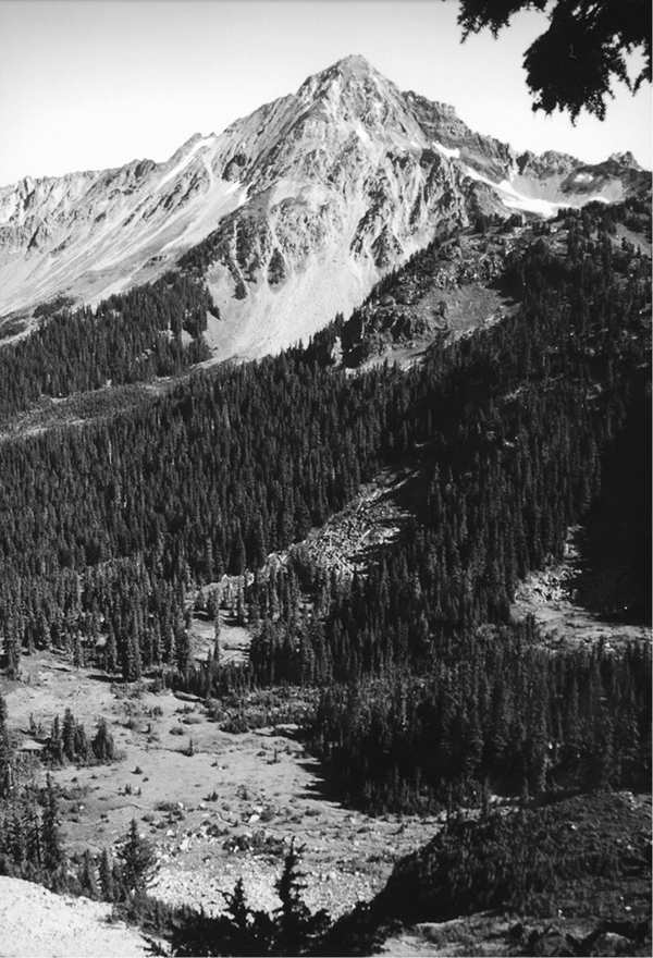
Mount Larrabee as seen from Gold Run Pass
39 Gold Run Pass and Tomyhoi Lake
A day hike to Gold Run Pass (5.4 miles round-trip) or a longer day hike or short backpack to Tomyhoi Lake (10 miles round-trip).
Best season: Early June to mid-October for Gold Run Pass; mid-July to mid-October for Tomyhoi Lake.
Elevation gain: 1,820 feet.
Elevation loss: 1,760 feet to Tomyhoi Lake.
Maximum elevation: 5,460 feet at Gold Run Pass.
Topo maps: Mount Larrabee; Mount Shuksan.
Jurisdiction: Mount Baker Wilderness (Mount Baker–Snoqualmie National Forest).
Finding the trailhead: From Glacier, drive east on Washington Highway 542 to mile 46, where a major gravel road branches away beside a highway maintenance compound. Turn left on this road (Forest Road 3065) and follow it for 4.5 miles to the Gold Run Pass trailhead.
The Hike
This trail makes a challenging climb over a narrow notch, then drops into the valley of Tomyhoi Creek, which drains northward into Canada. At the end of the trek is Tomyhoi Lake, a large lowland lake that stretches into Canada, where the clear-cuts march southward to the border. Tomyhoi Lake drains through subterranean passages beneath its bed, and in late summer the water is drawn down far below the high water mark. The hike to the lake is fairly moderate, but the return trip is a more strenuous proposition. Biting insects are abundant throughout the trek; bring lots of repellant.
The trail begins with a steady climb, switchbacking upward across brushy slopes that face southward toward Mount Baker. After a vigorous ascent, the path levels off and heads southwest. A mature stand of hemlock and silver fir shades the journey to a false pass on a ridgetop that divides Swamp Creek from a tributary stream that rises on the slopes of Yellow Aster Butte. The ridgetop is home to hemlocks that reach old-growth proportions.
The trail then climbs gently into subalpine parks that line the head of the tributary stream. The warning whistles of marmots can be heard from the slopes of Yellow
Mount Larrabee as seen from Gold Run Pass
Aster Butte, but the animals themselves are hard to spot without binoculars. Stay right as the Yellow Aster Butte Trail departs on its westward course from this basin. A steep final ascent leads upward across flower-strewn meadows that offer a fine parting view of Mount Baker and the closer summit of Goat Mountain. The path then leads over Gold Run Pass, a high col that bears a sparse growth of mountain hemlock. Northward views from the pass encompass Mount Larrabee and the Border Peaks, splashed with red and yellow hues that derive from iron and sulfur compounds within the bedrock.
The path then begins an insanely steep descent toward the headwaters of Tomyhoi Creek. The still waters of Tomyhoi Lake can soon be seen, guarded by the hulking massif of Tomyhoi Peak. Beyond the lake, clear-cuts and logging roads cover the hillsides beyond the international border. The path dives down the mountainside, ultimately leveling off on a meadowy shelf. There are campsites at the lower end of the shelf. Beyond this point, the trail adopts a more reasonable descent. The trail now threads its way down through the heather, overgrown boulders, and a sparse growth of hemlock. Marmots are often sighted along this stretch of the trail. The path soon enters the shade of mature forest. The trees part occasionally at wet meadows, and huckleberry bushes provide a tasty diversion when they ripen in mid-August.
The trail ultimately strikes a brushy stream and follows it down to Tomyhoi Lake. Just before reaching the lakeshore, the path crosses a snowslide swath that is choked with downed logs. It then tracks the stream down through a heavy growth of willows to the head of the lake. Tents can be pitched amid the driftwood on the lakeshore.

Miles and Directions
0.0Gold Run Pass–Tomyhoi Lake Trailhead.
0.6Trail enters Mount Baker Wilderness.
2.5Junction with Yellow Aster Butte trail. Stay right.
2.7Gold Run Pass.
4.4Trail crosses Tomyhoi Creek and follows east bank.
5.0Head of Tomyhoi Lake.