41 Welcome Pass and the High Divide
A day hike to Welcome Pass, 5 miles round-trip, or a longer day hike when combined with the Excelsior Pass Trail (car shuttle required), 11.3 miles overall.
Best season: Mid-June to mid-October for Welcome Pass; mid-July to mid-October for High Divide.
Elevation gain: 2,740 feet to Welcome Pass; 3,891 feet overall.
Elevation loss: 25 feet to Welcome Pass; 986 feet overall.
Maximum elevation: 5,790 feet along High Divide.
Topo maps: Mount Larrabee, Bearpaw Mountain; Mount Baker, Mount Shuksan.
Jurisdiction: Mount Baker Wilderness (Mount Baker–Snoqualmie National Forest).
Finding the trailhead: From Glacier, drive east on Washington Highway 542 to mile 45, where a primitive road (Forest Road 3060) runs north. Follow this road for 1 mile to the trailhead at its end; hikers without high-clearance vehicles should walk it.
The Hike
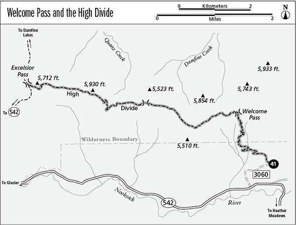
This mercilessly steep trail leads from the valley floor to the summit of the Nooksack River divide, where alpine meadows stretch westward to Excelsior Pass. The High Divide segment of the trail offers a spectacular diversity of wildflowers, as well as views that encompass both Mount Shuksan and Mount Baker. Alternate routes to the High Divide include the Excelsior Pass Trail (which can be combined with this route for a good day semi-loop) and the Damfino Lakes Trail, which begins at the head of Canyon Creek. Bring lots of water, because surface water is hard to find along the route.
The trek begins on an old logging road that climbs moderately through dense coastal forest. After 1 mile, the roadbed ends and an old prospector’s trail of surpassing steepness heads up the mountainside. As it climbs, the western hemlocks are replaced by silver fir. After sixty tight hairpins and an unrelenting grade, the trail breaks out onto steep meadows that offer southward views of the mountains. Mount Shuksan reigns above the North Fork of the Nooksack, with Icy Peak and Ruth Mountain to the left of it. The trail then climbs the final steep switchbacks to Welcome Pass. Trees screen off views to the south, but open meadows lead down into the head of Damfino Creek. Its valley is lined with barren crags, tallest of which is Tomyhoi Peak to the northwest.
Miles and Directions
0.0Welcome Pass Trailhead.
1.0Old road ends and trail steepens.
2.5Welcome Pass. Trail turns west along High Divide.
7.1Excelsior Pass. Junction with Excelsior Pass and Damfino Lakes Trails.
High Divide Option.
The trail now turns westward atop the meadowy crest of the High Divide, lit with the blossoms of bistort and arnica. The trail climbs along a small rift vale, passing several frog ponds as it runs south of the next high point. Look eastward for views that feature Goat Mountain and Mount Larrabee. The trail reaches its highest point at the next saddle, which overlooks a western branch of Damfino Creek. It then descends moderately across south-facing slopes, where the meadows reveal superb views of Mount Baker, with Mazama and Roosevelt Glaciers pouring down its north face.
The trail next meets the ridgeline at a lower saddle, perched above the gentler, forest-robed terrain of the Quartz Creek watershed. The path climbs and falls as it follows the divide, crossing deep swales filled with lupine and aster as well as colder exposures robed in mats of heather. The trail ends at a signpost in the flat saddle of Excelsior Pass, where the Damfino Lakes Trail runs north across the meadows and the Excelsior Pass Trail drops away toward the North Fork of the Nooksack.