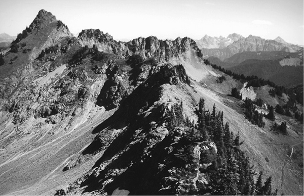
Looking toward the Border Peaks from Church Mountain
43 Church Mountain
A day hike to a former lookout site on a high spur of Church Mountain, 8.4 miles round-trip.
Best season: Early June to mid-October (snow lingers later in the Deerhorn Creek basin).
Elevation gain: 3,787 feet.
Elevation loss: None.
Maximum elevation: 6,100 feet at the lookout site.
Topo maps: Bearpaw Mountain, Glacier; Mount Baker.
Jurisdiction: Mount Baker–Snoqualmie National Forest.
Finding the trailhead: From Glacier, follow Highway 542 east to a junction with Forest Road 3040 at mile 38.7. Follow this narrow but passable logging road upward for 3 miles to reach the trailhead.
The Hike
A long climb through the timber leads up to alpine meadows on the slopes of Church Mountain, and from here the trail climbs to the former site of a fire lookout atop one of the mountain’s eastern buttresses. The trail makes an excellent day hike, with outstanding views of the surrounding peaks and good berry pickings on the slopes below the peak.
The trek begins on an old logging road that climbs through a regenerating clear-cut. After a short distance, the Church Mountain Trail departs from the roadbed and climbs into tall timber that grew in the wake of logging. Views through the canopy are limited to ridges that border the North Fork of the Nooksack River, which themselves bear the scars of the timber industry. A long and tedious ascent leads up through mature hemlocks and Douglas firs, zigzagging upward at a steady and relentless pace.
Looking toward the Border Peaks from Church Mountain
Near the top of the initial grade, the trail runs westward into a fold in the hills that bears many small streams. Steep and narrow snowslide meadows alternate with ribbons of timber. The trail ultimately breaks out into a broad basin overlooked by the upthrust buttresses of Church Mountain. The path runs westward across the floor of the basin, passing through a diverse assemblage of wildflowers and dwarf shrubs. Mount Baker and the Twin Sisters show themselves immediately, and Mount Shuksan is visible from the far side of the basin.
The trail now zigzags upward once more, passing over a spur ridge then continuing its ascent above a smaller bowl. Visits to the crests of various spur ridges yield northwesterly views of Tomyhoi Peak and the Border Peaks, with an ever-increasing sea of snowcapped summits spreading westward. The trail ultimately reaches the nose of a rocky pinnacle, then threads its way up a steep course through the rock to reach the lookout site.
The fire lookout was torn from its moorings and dashed against the mountainside during a recent winter storm; its former perch yields fantastic views in all directions. The aquamarine Kidney Lakes occupy the shallow and barren basin to the north; adventurous hikers can attempt to scramble down through cliffs to the water. To the west is the rocky summit of Church Mountain, with a broad reach of salt water beyond it. Sighting eastward down the tree-mottled crest of the High Divide, the tallest of the distant crags is Mount Redoubt. The northern horizon is crowded with the snowy summits of the Coast Mountains in British Columbia, which rise beyond the deep trench of the Fraser River Valley.
Miles and Directions
0.0Church Mountain Trailhead.
2.5 Upper basin of Deerhorn Creek.
4.2Trail reaches site of Church Mountain fire lookout.
