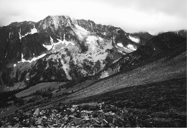
Castle Peak from Frosty Mountain
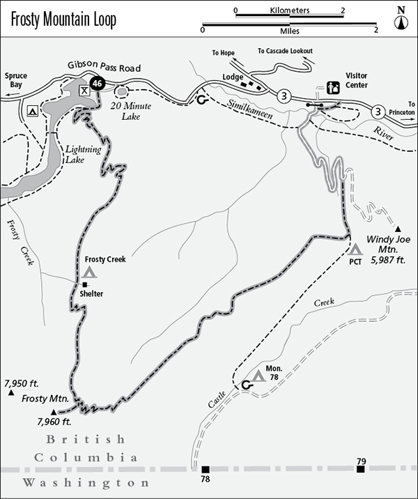
46 Frosty Mountain Loop
A long day hike or backpack to the east summit of Frosty Mountain, 27 km (16.8 miles) overall.
Best season: Late June to mid-October.
Elevation gain: 1,173 m (3,850 feet) west to east.
Elevation loss: 1,234 m (4,050 feet) west to east.
Maximum elevation: 2,408 m (7,900 feet) at the summit of Frosty Mountain.
Topo maps: Manning Park–CGS; the rebuilt trail is not shown.
Jurisdiction: Manning Provincial Park.
Finding the trailhead: Take British Columbia Highway 3 to the junction at the Manning Park Lodge. Turn south on Gibson Pass Road for 3 km (2 miles), then turn left at the Lightning Lake day-use area and park. The trail begins by crossing the dam at the lake’s outlet. It ends at the Pacific Crest Trail (PCT) trailhead, 1 km east of the Manning Provincial Park Visitor Centre on BC 3. Through-hikers can arrange a car shuttle, or hike 4 km (2.5 miles) on the Similkameen River Trail to complete the loop.
The Hike
This popular route climbs from Lightning Lake to the eastern summit of Frosty Mountain for views deep into the heart of the Pasayten Wilderness. It then descends along a ridgetop to intersect the old fire road to Windy Joe Mountain, which it follows down to a trailhead on BC 3. The trek ends here for hikers who use a two-car shuttle; alternately, the loop can be closed by trails that follow the Similkameen River back to Lightning Lake. The trip can be completed in a single day by hikers of great stamina, but two camping areas along the way allow the trek to be approached at a more comfortable pace.
From the Lightning Lake day-use area, the trail crosses a dam to reach a marked junction on the far shore of the lake. Turn left as the Frosty Mountain Trail begins a steady climb through a forest of spruce and hemlock. As the path switchbacks upward, these conifers are replaced by lodgepole pine. Several openings reveal Lightning and Flash Lakes in the valley below. As the trail approaches the ridgetop, the pines are in turn replaced by subalpine fir. The path ultimately reaches level country atop the ridge, and sun-splashed clearings interrupt the forest at regular intervals. The first views of Frosty Mountain come from these rolling uplands. Subalpine firs and whitebark pine close ranks around the trail as it approaches Frosty Creek camp, where a log shelter stands beside a spring-fed trickle of water.
The trail soon begins to climb again, rising above the forest onto a higher ridgetop where open meadows are guarded by sparse stands of subalpine larch. Larches are unique among conifers in that their needles turn brilliant gold in autumn and fall off with the onset of winter. The twin summits of Frosty Mountain now rise impressively to the south, and the trail wanders toward them through open country. The long meadows ultimately end as the path climbs through a bleak landscape of bedrock domes to reach the foot of the mountain. A precipitous climb leads up across a slope of frost-riven boulders to reach a wind-blasted signpost.
Castle Peak from Frosty Mountain
From here, the trail to the summit is little more than a pale track through the boulders where hikers’ boots have worn off the black crust of lichens. Expect slow going as the path leads up the ridgeline to the eastern summit of Frosty Mountain, where a rockwork ring beside a large cairn provides shelter from the wind. Views are limitless from this highest point in Manning Provincial Park, featuring Castle Peak and Mount Winthrop guarding the emerald parks of Castle Creek. To the west are the sharp crags of Hozomeen Mountain with the summit of Mount Spickard beyond them. The lesser summits of the northernmost Cascades are spread in an arc to the north. From west to east, the principal summits are Silvertip Mountain, Snass Mountain, Three Brothers Mountain, and finally Chuwanten Mountain beyond Castle Creek.
Meanwhile, the loop trail descends northward from the signpost, zigzagging downward with impressive views of Castle Peak along the way. The trail bottoms out in broad meadows where anemones and lupines bloom, and larch and fir form stately clusters along the margins. The trees become more numerous with northward progress along the level ridgetop, forming an enchanting parkland that offers fine views of Mount Winthrop. This subalpine woodland, a mixture of fir, whitebark pine, and spruce, ultimately yields to a montane stand of Douglas fir and lodgepole pine as the trail drops steadily from the ridgetop to reach the timbered saddle at the base of Windy Joe Mountain.
Here, the Pacific Crest Trail (PCT) rises up from the lowlands of Castle Creek to join the Frosty Mountain route; a 1-km jaunt down this trail leads to PCT Camp. The loop trail now traverses northwest and soon encounters the old Windy Joe fire access road, now closed to motorized traffic. Diehard hikers can hike up the road to the summit of Windy Joe Mountain, where interpretive panels identify the surrounding peaks. Windy Joe Mountain was named for a local trapper who vociferously claimed that high winds kept the summit free of snow all winter.
To complete the hike, follow the road downward through lodgepole pines growing on slopes that burned in the 1800s. The road soon encounters a small stream; the moist bottomlands were spared by the blaze and contain a mixture of spruce and hemlock that is representative of the pre-fire forest. The road then descends steadily into the valley of the Similkameen River. Near the bottom of the grade, the Similkameen Trail departs from the road and runs westward; hikers completing the loop on foot should turn left here. To reach the highway, follow the road across the river to the horse corrals, then turn east past the sewage lagoons to reach the PCT Trailhead.
Miles and Directions
kmmiles
0.00.0Trailhead at Lightning Lake day-use area. Trail crosses dam.
0.30.2Junction with Lightning Lake Loop Trail. Turn left to start upward.
9.25.7Frosty Creek Shelter.
13.48.3Junction with spur trail to summit (0.5 km/0.3 mile, moderate). Bear left to complete the loop.
21.113.1Junction with PCT. Turn left.
22.413.9Junction with Windy Joe Trail. Turn left onto roadway.
25.716.0Junction with Similkameen Trail. Turn left to complete the loop on foot (4 km/2.5 miles), or right to reach the PCT Trailhead.
25.916.1Junction with eastbound Similkameen Trail. Stay left.
26.116.2Trail crosses Similkameen River.
27.016.8PCT Trailhead.