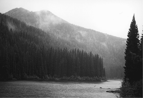
Storm at Strike Lake
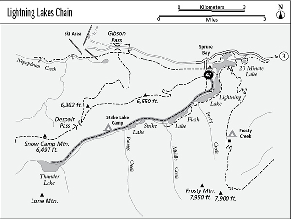
47 Lightning Lakes Chain
An array of possible day hikes and loops, 20 km (12.4 miles) to Thunder Lake and back.
Best season: Mid-May to late October.
Elevation gain: None.
Elevation loss: 73 m (240 feet) to Thunder Lake.
Maximum elevation: 1,250 m (4,100 feet) at Lightning Lake.
Topo maps: Manning Park–CGS; not all trails are shown.
Jurisdiction: Manning Provincial Park.
Finding the trailhead: Take British Columbia Highway 3 to the junction at the Manning Park Lodge. Drive south on Gibson Pass Road for 6 km (4.2 miles), then turn left at Spruce Bay turnoff and park at the trailhead.
The Hike
In the heart of Manning Provincial Park, a chain of lakes at the head of Lightning Creek occupies a timbered low spot on the Cascades divide. Lightning Lake is the largest of these, and because it is accessible by road, it is a popular spot for picnics and canoe trips. A network of trails rings the lakes, allowing a diverse array of day-hikes of varying lengths. One could hike completely around both Lightning and Flash Lakes, while the main trail follows the western shores of the lakes and also visits the more remote waters of Strike Lake and Thunder Lake. These boreal lakes are outstanding spots for wildlife viewing, with waterfowl and beaver active on the water and opportunities to view spawning rainbow trout at the outlet of Lightning Lake during early summer.
The trail begins by wandering through the towering Engelmann spruce that border Spruce Bay. These trees are narrow and spire-shaped to shed heavy accumulations of winter snow. The wide path soon nears the shore of Lightning Lake; a narrow angler’s trail runs along the lakeshore while the broad Lightning Lakes Chain path charts an inland course. The Skyline Trail soon splits away to the right, while the main trail continues to the foot of the lake. A loop trail leads around the far shore, and a short distance along it leads to a bridge over the spot where the rainbow trout spawn.
Ahead lies Flash Lake, beyond a short stretch of bottomland forest. This picturesque lake is endowed with islands and peninsulas robed richly in spruce. Choose either shore to pass around the lake. Beyond it, a short jog through the forest leads to open marshes of emerald green sedge, created by the past flooding activities of beaver. These industrious animals have since moved on, leaving the gemlike wetland to smaller creatures. After wandering through the lowland forest, the trail arrives at Strike Lake, a clone of the two upper lakes. There are several bare spots along the shoreline, but backpackers should continue on past the foot of the lake for 1 km (about 0.62 mile) to reach Strike Lake Camp in a grove of fir.
The trail passes through the midst of the camp, then onward through an increasingly dry and open landscape. Early talus slopes reveal the bare flanks of Snow Camp Mountain ahead, and the stately spruces are replaced by Douglas firs that are better suited to this arid landscape. The path crosses a broad apron of scree as it approaches Thunder Lake. The lake’s bleak basin is fringed by tall cottonwoods, and the water level often drops well below the shoreline as the waters drain through underground channels in the shattered basin rock. The trail wanders halfway around its shore to end in the trees west of the lake.
Storm at Strike Lake
Miles and Directions
kmmiles
0.00.0Spruce Bay Trailhead.
0.30.2Junction with angler’s trail. Bear right and follow Main Trail signs.
1.10.7Junction with Skyline II Trail. Bear left.
2.01.2Head of Lightning Lake. Junction with Lightning Lake Loop Trail. Stay right.
2.31.4First junction with Flash Lake Loop Trail. Stay right.
2.41.5Head of Flash Lake.
3.42.1Foot of Flash Lake.
3.72.3Second junction with Flash Lake Loop. Keep right.
4.52.8Head of Strike Lake.
5.83.6Foot of Strike Lake.
6.94.3Strike Lake Camp.
9.35.8Head of Thunder Lake.
10.06.2Trail ends.