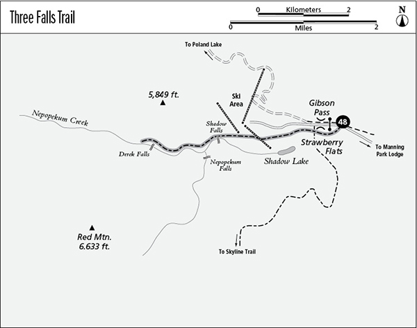
48 Three Falls Trail
A half-day hike to Derek Falls, 9 km (5.6 miles) round-trip.
Best season: Early June to late October.
Elevation gain: None.
Elevation loss: 177 m (580 feet) to Derek Falls.
Maximum elevation: 1,365 m (4,480 feet) at Gibson Pass Trailhead.
Topo maps: Manning Park–CGS.
Jurisdiction: Manning Provincial Park.
Finding the trailhead: Take British Columbia Highway 3 to the junction at the Manning Park Lodge. Drive south on Gibson Pass Road for 10 km (7 miles) to reach the Strawberry Flats Trailhead at the locked gate to the ski area.
The Hike
This trail offers a half-day trip from Gibson Pass, visiting three striking waterfalls along Nepopekum Creek. The trail begins in a lodgepole pine savannah that covers the flats of Gibson Pass. The pines got their start following a forest fire, and now a young crop of shade-tolerant spruce seedlings is growing up to replace them. After passing a junction with the Skyline I Trail, the wide track enters the grassy clearings of Strawberry Flats. In addition to wild strawberries, the flats are home to a diverse mixture of flowering plants, featuring tiger lily, monkshood, and lupine. The peak blooming occurs in late July.
As flower-studded meadows give way to subalpine forest, the path runs beneath one of the chairlifts of Gibson Pass Ski Area. After climbing across the ski run, the trail returns to a virgin stand of subalpine fir. The timber is dense as far as Shadow Falls, where an overlook is cordoned off by a split-rail fence. The falls are most spectacular in early June and taper off to a trickle by late summer.
Beyond the overlook, the path begins a steady descent into the deep canyon of Nepopekum Creek. Early in the descent, talus slopes reveal the green sail of Snow Camp Mountain and the bleaker summit of Red Mountain. Nepopekum Falls soon appears on the far side of the valley, a slender cascade that plummets from a hanging basin down a sheer wall of stone. Continuing downhill, the trail makes its way into timbered bottoms, where the silver fir and western hemlock so typical of the coastal forest are dominant. Soon, rushing Derek Falls can be heard, and the trail makes its way out onto a talus slope for a striking view of the cataract. Evidence of avalanches and rockslides is everywhere, and the trail ends at a warning sign just beyond the viewpoint.
Miles and Directions
kmmiles
0.00.0Trailhead.
0.30.2Strawberry Flats.
0.90.5Junction with Skyline I Trail. Continue straight ahead.
1.81.1Trail passes beneath ski lift.
3.11.9Shadow Falls overlook.
3.52.2Nepopekum Falls viewpoint.
4.52.8Derek Falls viewpoint and end of trail.