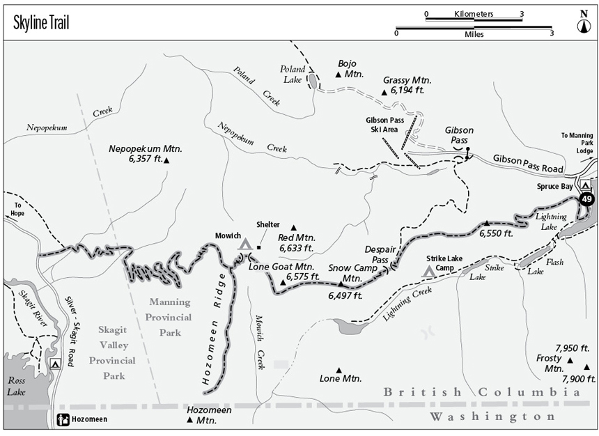
49 Skyline Trail
A backpack from Lightning Lake to the Skagit Valley, 36.2 km (22.5 miles) overall.
Best season: Mid-June to mid-October.
Elevation gain: 1,353 m (4,440 feet) east to west.
Elevation loss: 2,091 m (6,860 feet) east to west.
Maximum elevation: 1,932 m (6,340 feet).
Topo maps: Manning Park–CGS (Skyline I and Hozameen Ridge trails not shown); Skagit River–CGS (trail location approximate).
Jurisdiction: Manning Provincial Park, Skagit Valley Provincial Park.
Finding the trailhead: Take British Columbia Highway 3 to the junction at the Manning Park Lodge. Drive south on Gibson Pass Road for 6 km (4.2 miles), then turn left at Spruce Bay turnoff and park at the trailhead. The trail begins at the Spruce Bay Trailhead and ends at the Whitworth Meadow Trailhead, an unmarked pullout at km 54 (mile 33.6) on the Silver-Skagit Road. Through-hikers will need to arrange a car shuttle.
The Hike
The crown jewel of Manning Provincial Park, this trail follows alpine ridgetops from Lightning Lake to the Skagit River valley, offering astounding views of Hozomeen Mountain as well as Castle Peak to the east. The trail will be described along its original route, although it might also be approached from Gibson Pass via a newer trail that climbs to the ridgetop from the north. This newer trail (now known as Skyline I) can be combined with the old trail (Skyline II) for a day trip from Gibson Pass to Lightning Lake. Backpackers can pitch their tents at the remote Mowich Camp and make southward forays on the Hozomeen Ridge Trail. The trail from Hozomeen Ridge down to the Skagit Valley was once quite steep but has been rebuilt and is now quite manageable.
From the Spruce Bay parking area, follow the Lightning Lakes Chain Trail southward around the shore of Lightning Lake. Follow signs marked Main Trail as the wide pathway crosses spruce bottoms to reach its junction with the Skyline Trail. This route initially follows an old road grade that ascends steadily through dense stands of spruce and hemlock as it winds onto the north side of the ridge. The footpath begins here, making a long but moderate climb through the trees before a sharp hairpin leads back to the ridgeline. Sharp ascents alternate with level stretches as the path follows the ridgetop upward to a series of burns. Lightning strikes are common on these high ridges, and when the forest is dry, they ignite small wildfires. The burns yield fine views of Frosty Mountain, the northernmost peak of the rugged and glacier-carved crest of the Cascades.
As the trail climbs to timberline, hikers get views of Flash Lake, distant Thunder Lake, and finally Strike Lake in the valley below. A bald and rocky knob marks the top of the initial grade; beyond this point, the route rises and falls with the changing pitch of the ridgetop. The eastern slope is covered in an arid parkland punctuated by subalpine fir and whitebark pine, but the north-facing bowls are robed in lush meadows. Northward views encompass Gibson Pass Ski Area, as well as the solitary horn of Silvertip Mountain with its diadem of glacial ice.
After surmounting the first three knolls, the trail drops onto south-facing slopes to cross a broad and flower-spangled grassland. One can now look straight up Passage Creek at the summit of Castle Peak, which lies just south of the international border. The trail enters a woodland of impressive subalpine firs as it continues across the mountainside. After a short distance, the rim of a steep dropoff commands views of Thunder Lake. The lake is guarded by the meadowy dome of Lone Mountain, with the spires of Hozomeen Mountain rising beyond.
The Skyline I segment of the trail now rises from Gibson Pass to join the main trail at a marked signpost; hikers bound for Mowich Camp will now switchback down into Despair Pass. The pass is wooded in spruce and fir, with a dense understory of shrubs that includes huckleberry and dwarf blueberry. After bottoming out, the path climbs to the north of the ridgecrest, rising through tidy heather meadows that are protected by the trees.
Suddenly, the trail breaks out onto the high and windswept grasslands atop Snow Camp Mountain. These heights face straight down Lightning Creek at the cathedral spires of Hozomeen Mountain, and also offer fine views of the peaks to the east. Looking west across the divide formed by Hozomeen Ridge, the summits of Mox Peaks, Mount Spickard, and Custer Ridge crowd the distant horizon.
After traversing below the summit of Snow Camp, the trail drops into a saddle at the base of Lone Goat Mountain. Red Mountain now rises to the west. Late summer berry pickings can be good where the trail climbs across the face of Lone Goat, then rounds the peak and makes a northward descent across open bowls. Mowich Camp occupies the low saddle at the head of Mowich Creek, boasting a log shelter beside a pair of picturesque wet meadows.
An easy grade now leads to the top of the Hozomeen Ridge, where the Hozameen Ridge Trail splits away to the south. The main trail drops onto the western slope of the ridge and traverses northward, first through an open subalpine woodland and then onto open slopes. There are superb parting views of Hozomeen Mountain, as well as of the head of Ross Lake and the peaks that rise beyond it. A long finger ridge extends into the Skagit Valley, and the trail follows it to begin its long descent.
The path enters heavy timber upon rounding the end of the ridge. Douglas firs are draped with goat’s beard on the southwest exposures, while hemlocks dominate the cooler north-facing slopes. After a long descent, the trail crosses a major stream. It then enters Skagit Valley Provincial Park as it climbs onto a series of timbered terraces. Another substantial descent leads to the valley floor, and after passing a junction with the Centennial Trail, the path makes its way to the Silver-Skagit Road at the site of the old Whitworth Ranch.
Miles and Directions
kmmiles
0.00.0Spruce Bay Trailhead. Follow signs for Main Trail.
1.10.7Junction with Skyline II Trail. Turn right to begin the ascent.
6.33.9Trail reaches the ridgetop.
14.28.8Junction with Skyline I (cutoff to Gibson Pass). Turn left.
15.19.4Despair Pass.
17.711.0Snow Camp Mountain.
23.214.4Mowich Camp.
23.814.8Junction with Hozameen Ridge Trail (5.3 km/3.3 miles, moderate). Continue straight ahead for the Silver-Skagit Road.
33.320.7Junction with Centennial Trail. Bear left.
36.222.5Whitworth Meadow Trailhead on Silver-Skagit Road.
Hozomeen Ridge Option
This trail began as a climber’s route to Hozomeen Mountain, and follows the ridgetop southward through subalpine parks to the international border. The pace is moderate but includes several killer grades to discourage the fainthearted. Leaving the Skyline Trail, the route meanders across rounded hillocks and through pocket vales ringed by subalpine fir. Westward views feature Mox Peaks, Mount Spickard, and Custer Ridge beyond the head of Ross Lake. Straight ahead, the north peak of Hozomeen rises like a beacon. The path dodges to the east side of the ridge while surmounting the first high point, and open slopes yield excellent views of Castle Peak. The trail tackles the second summit head-on, and after a long descent it reaches the first rocky battlement of Hozomeen Mountain. The trail snakes upward at an insanely steep angle and, between gasps, visitors may notice a subtle shift from subalpine fir to the mountain hemlock and Alaska cedar typical of the coastal subalpine zone. The path peters out atop this high spur, with full-face views of the north peak of Hozomeen.