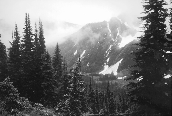
Clearing storm along Deception Pass Trail
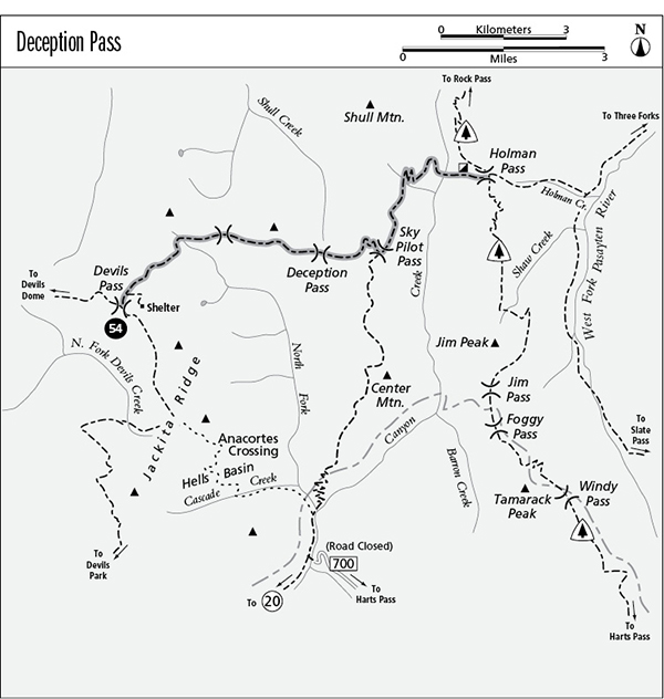
54 Deception Pass
A connecting trail that links Devils Pass with the Center Mountain and Cascade Crest routes, 8.2 miles overall.
Best season: Mid-July to mid-October.
Elevation gain: 2,405 feet (east to west).
Elevation loss: 1,445 feet (east to west).
Maximum elevation: 6,300 feet at Sky Pilot Pass.
Topo maps: Shull Mountain, Pasayten Peak; Pasayten Peak, Jack Mountain.
Jurisdiction: Pasayten Wilderness (Okanogan National Forest).
Finding the trailhead: The west end of the trail can be reached via an 11.2-mile jaunt on the Cascade Crest route, while the eastern end of the trail joins the Jackita Ridge Trail 15.2 miles from Washington Highway 20. The trail can also be accessed via Devils Dome and Center Mountain.
The Hike
This remote trail links Devils Pass with the Cascade Crest Trail, enabling hikers to combine the Devils Dome or Jackita Ridge Trails with other alpine ridge treks for a spectacular extended traverse across some of the most remote high country of the Pasayten Wilderness. The trail itself is pleasant but unspectacular, with mountain vistas at regular intervals. Camping spots can be found below Devils Pass or in the nameless basin 1.4 miles east of it.
From its beginning at Devils Pass, the Deception Pass Trail runs northeast across open meadows dominated by phlox and other alpine wildflowers. The spur path to Devils Pass shelter soon drops away to the right, while the main trail maintains its altitude across the mountainside. There are fine views of the multiple summits of Jackita Ridge, which rises beyond a small valley that bears the North Fork of Canyon Creek. The scars of avalanches and rockslides extend from the far slopes down to the valley floor, where a small and inaccessible lake is nestled amid meadows and timber.
In time, the path begins a gradual ascent and soon works its way around to the floor of a rocky cirque. A nameless summit rises high above the bowl, and hoary marmots may be spotted among the boulders closer at hand. After passing good camping spots, the trail descends into a rather brushy subalpine forest, where in late summer an abundance of huckleberries compensates for the lack of views. The path flirts briefly with the ridgetop as it works its way down, then drops onto south-facing slopes to round the next mountainside. On its slopes, the forest is interrupted periodically by sunny meadows, populated by a vigorous growth of flowering plants.
Clearing storm along Deception Pass Trail
The path soon begins a steady descent into the low and timbered saddle of Deception Pass, which divides Shull Creek from the North Fork of Canyon Creek. Here, hikers get limited views of Shull Mountain to the north. The trail now climbs onto the boggy slopes to the east, crossing several rivulets before breaking out into the open meadows below Sky Pilot Pass. As the trail climbs higher through the meadows, views open up to the west and south. The jagged peaks beyond Shull Creek are nameless, while to the southwest are the jumbled spires of Jackita Ridge. Between these two groups of nearby summits, the much taller miter of Jack Mountain can be seen through the low gap of Devils Pass.
The trees close in as the trail climbs the final pitch to Sky Pilot Pass, and the pocket meadows of the pass itself offer no distant views. From atop the divide, the Center Mountain trail runs southward, while the main trail continues through the pass and turns north above the valley of Canyon Creek. Heather parklands give way to subalpine forest as the trail descends steadily, and openings in the forest face down the valley toward the mighty summit of Mount Ballard. Clumps of lupine light the way in midsummer. A small stream beneath a northern spur of Shull Mountain offers fine camping spots in the high country.
As the trail begins its descent to the valley floor, openings reveal Holman Pass, with the barren summits of Gold and Buckskin ridges framed within the low gap. After many downward switchbacks, the path reaches a shallow ford of Canyon Creek, with a small trailside camping spot on the far bank. Beyond it the trail ascends gently through a flooded forest of old spruce, then makes the short climb to Holman Pass. Along the way is a small log shed that has been attributed to trappers Henry Bihart and Henry Kuykendall. Within the wooded flats of the pass, the trail links up with the Pacific Crest Trail, and a connecting trail continues eastward to the West Fork of the Pasayten River.
Miles and Directions
0.0Devils Pass. Junction with Jackita Ridge and Devils Dome Trails.
0.1Spur trail descends 0.3 mile to Devils Pass Shelter. Bear left.
1.4Campsite in cirque above North Fork of Canyon Creek.
3.7Trail bottoms out at Deception Pass.
5.4Sky Pilot Pass. Junction with Center Mountain Trail. Continue straight ahead.
6.2Campsite in elevated basin.
7.5Canyon Creek crossing.
8.2Holman Pass and junction with Cascade Crest Trail.