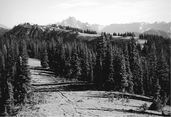
Looking along Center Mountain toward Mount Ballard
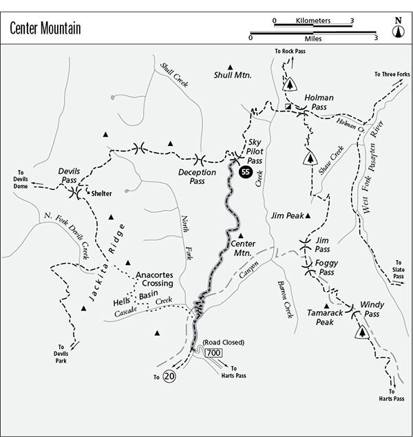
55 Center Mountain
An extended trip from Sky Pilot Pass to Chancellor Camp, 6.6 miles.
Best season: Mid-July to mid-October.
Elevation gain: 316 feet (north to south).
Elevation loss: 3,766 feet (north to south).
Maximum elevation: 6,560 feet.
Topo maps: Shull Mountain; Jack Mountain.
Jurisdiction: Pasayten Wilderness (Okanogan National Forest).
Finding the trailhead: The north end of the trail is reached via a long trek on the Deception Pass Trail from the Jackita Ridge, Devils Dome, or Cascade Crest routes. The south end of the trail can be reached via the Chancellor Trail (8.3 miles) or by hiking 3.5 miles down the old Slate Creek Road (Forest Road 5400-700) from the washout. This road is reached via Harts Pass.
The Hike
This remote trail links Sky Pilot Pass with the old Chancellor Camp at the confluence of Slate and Canyon creeks. Visitors cross spectacular meadows with panoramic views on the upper reaches of the trail, while the lower section features a long and tedious descent from the top of Center Mountain to the valley bottoms. It’s a horse-killer from south to north; travelers are advised to approach the route from Sky Pilot Pass. The trail receives little maintenance, offering a few route-finding challenges and downed trees to negotiate. For this reason, it is an excellent place to avoid crowds.
From the junction at Sky Pilot Pass, the trail climbs southward along an open ridgeline. Look north for views of Shull Mountain; Joker Mountain appears far to the northwest while the grassy summits of Holman Peak guard the upper basin of Canyon Creek to the northeast. Before reaching the first summit on the ridgeline, the trail turns onto east-facing slopes and traverses the meadowy steeps. Watch for marmots among the boulders below the trail. On the far side of the summit, the path returns to the ridgeline. The gray tooth of Pasayten Peak now appears above an intervening ridgetop to the east, and the glacier-carved horns of Jackita Ridge rise to the west beyond the low divide of Deception Pass.
The trail now descends onto open meadows that crown the level surface of Center Mountain. Orderly groves of subalpine fir and spruce create a parklike setting here. The trail may disappear in places, overgrown with grasses and wildflowers. It sticks generally to the ridgeline, dipping slightly to cross a low saddle and then climbing a bit to crest the next high point. The summit of Center Mountain now mounds up directly ahead, while the regal crest of Jack Mountain can be seen above the lesser summits of Jackita Ridge. To the south is a broad panorama of peaks, dominated by Mount Ballard with the lower crest of Majestic Mountain rising beyond it.
Looking along Center Mountain toward Mount Ballard
Dipping into a low saddle, the path becomes quite faint as it traverses westward across the grassy slopes of Center Mountain, passing beneath a scattering of subalpine larch that finds good growing conditions on this cold exposure. After rounding the mountainside, the trail turns south again and traverses along gentle, meadowy slopes. Before reaching the ridgeline, it dips into the trees. The meadows decrease in size and frequency until the trail drops steadily across slopes timbered in a loose subalpine forest. Grouse whortleberry grows on the forest floor as the trail angles down the mountainside on a vaguely southerly course.
The path ultimately returns to the ridgeline for a near-vertical descent. Huckleberry bushes soon encroach into the pathway, but they thin out as subalpine firs give way to Douglas firs of the montane forest. After a considerable drop in elevation, the trail reaches the first in a long series of switchbacks (reportedly there are sixty-four). The descent now eases to a more reasonable pace, and ultimately the forest canopy opens a bit to reveal glimpses of Cady Point and Jackita Ridge. The trail bottoms out in the deep shade of a cedar forest at the confluence of the main and north forks of Canyon Creek. Follow the North Fork to find a shallow ford or logjam crossing to the west bank. Here, an abandoned trail runs westward, climbing through Hells Basin to reach Anacortes Crossing.
The main trail continues south along the streambank, surmounting small rises and crossing a brushy clearing where thimbleberries may obscure the trail. Hikers must make a vigorous climb before the trail crosses the foot of a large talus slope to reach its end at a bridge that leads to Chancellor Camp. The Chancellor Trail continues southward along Canyon Creek for 8.3 miles to reach WA 20.
Miles and Directions
0.0Sky Pilot Pass.
1.6Trail passes summit of Center Mountain.
5.6Bottom of grade.
5.7North Fork of Canyon Creek and junction with the old Anacortes Crossing trail. Turn left.
6.6Bridge to Chancellor Camp. Junction with Chancellor Trail.