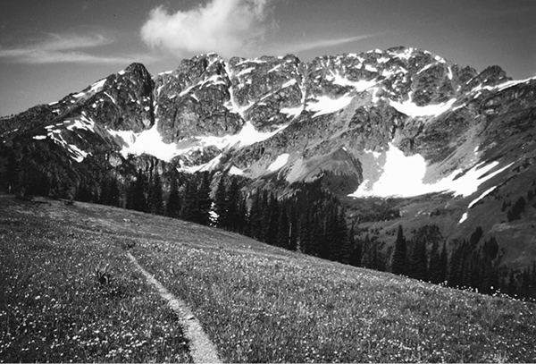
Shull mountain and meadows
56 Cascade Crest—Pacific Crest Trail
A day hike to Tamarack Peak (8.2 miles round-trip) or a long backpack to Manning Provincial Park in Canada (37.2 miles overall).
Best season: Late July to mid-October.
Elevation gain: 4,564 feet (south to north).
Elevation loss: 7,104 feet (south to north).
Maximum elevation: 7,090 feet atop Devils Stairway.
Topo maps: Slate Peak, Pasayten Peak, Shull Mountain, Castle Peak; Manning Park–CGS; Washington Pass, Jack Mountain, Pasayten Peak.
Jurisdiction: Pasayten Wilderness (Okanogan National Forest), Manning Provincial Park.
Finding the trailhead: Take Washington Highway 20 to the Mazama cutoff road, 11 miles west of Winthrop. After a mile, there is a T intersection. Turn left, passing the Mazama General Store. This is Harts Pass Road (Forest Road 5400), which is paved as far as the Lost River, about 5 miles. It then becomes gravel and is narrow and winding with many potholes as it makes the steep climb past Deadhorse Point to reach Harts Pass, 18.5 miles from Mazama. Turn right onto Forest Road 5400-600 and follow it 1.5 miles to the Pacific Crest Trail (PCT) Trailhead at the first switchback.
The Hike
The northernmost section of the Pacific Crest Trail is one of the most awe-inspiring stretches of this storied route. It follows the ridgetops for almost the entire length between Harts Pass and the Canadian border. The Pasayten Wilderness presents a sea of barren peaks that stretch to the far horizons, and bordering the trail are brilliant constellations of meadow wildflowers. Water can be hard to find along the route, and well-worn camping spots are uncommon. Locate your campsite on grassy spots or atop snowbanks to ease your impact on the landscape.
Travelers who hike this trail into Canada must obtain special permission from Customs officials. Through-hikers tend to arrive at the north end of the PCT in mid-September, but solitude reigns during the summer months, at least in areas more than 5 miles from Slate Peak. Bring an ice axe if you plan to travel between Rock and Woody Passes before mid-August.
The trek begins with a moderate climb through alpine meadows on the shoulder of Slate Peak. The summit of the peak is visible ahead, crowned with a fire lookout tower. During the Cold War, the top of the peak was razed and flattened to make space for a radar installation; when the new fire lookout was built on the site, it was built so that the floor of the cabin was at the altitude of the original summit. The trail levels off as it traverses northward across the steep and open slopes of the peak. Lupine and Indian paintbrush bloom in the moist meadows, while the drier slopes are home to phlox and cinquefoil. Panoramic westward views encompass the heart of the North Cascades. The dominant summit amid a crowd of peaks to the southwest is Mount Ballard. Due west, the two snowy peaks are Crater and Jack Mountains. As the trail continues northward, the distant volcanic cone of Mount Baker appears between them, clad eternally in ice and snow.
The trail soon crosses the shallow, grassy basin that bears the headwaters of Benson Creek. It then makes its way over a meadowy shoulder of the mountain, unveiling views of the extensive mine workings in the Indiana Basin. During the late 1800s, miners worked their way upstream from placer gold deposits in Canyon Creek, seeking the mother lode. Alec Barron found the lode in this basin in 1891, igniting a boom of hard-rock mining in the area. Shafts were blasted into the heart of the mountain as miners followed the veins of quartz and gold. Enormous heaps of waste rock, called tailings, were piled beneath the portals of the shafts, and they can still be seen today.
The path descends to cross through Windy Pass, then traverses the east-facing slopes beyond it. There are now views of the barren ridge of crags beyond the West Fork of the Pasayten. The tallest of the crags is Pasayten Peak. The rocky summit that rises above the trail is Tamarack Peak, named for the abundance of tamarack, or subalpine larch, on its northern slopes. The path soon zigzags up to a high saddle behind a rocky spur of the peak, then begins the long descent to Foggy Pass. Looking northward beyond the grassy summit of Jim Peak, one can see the forbidding countenance of Shull Mountain. To the west, the sharp summits of Jackita Ridge rise beyond the meadowy domes of Center Mountain.
The trail ultimately slips through Foggy Pass onto the west-facing slopes beyond. Here, copses of subalpine fir rise among flower-strewn meadows. After rounding the next knob, Jim Pass leads the trail back into the West Fork Pasayten drainage. The trail passes beneath the vast grasslands on the south face of Jim Mountain, then enters an open woodland of fir and mountain hemlock. It emerges at the base of the Devils Backbone, a bare spine that extends northward into the valley, hemming in the Shaw Creek watershed. A faint path follows the meadowy crest of the Backbone, while the main path zigzags down to cross the many rills that join to form Shaw Creek. Bouldery meadows offer habitat to marmots. Later, avalanche chutes allow growing space for white rhododendrons.
The trail soon enters a full-blown subalpine forest, and the views disappear as the path climbs steadily across the mountainside. At the north end of the ridge, openings in the trees reveal a rank of spectacular summits rising to the north: Shull Mountain, Powder Mountain, and Three Fools Peak. The path then embarks upon a long and tedious descent into Holman Pass. These moist, north-facing slopes are protected from forest fires, creating conditions that favor Engelmann spruce as the dominant tree. At the bottom of the grade is a well-marked junction in the deeply wooded pass. To the right, a connector trail descends to the West Fork of the Pasayten; to the left the Deception Pass Trail runs westward toward Devils Dome; and straight ahead lies the Cascade Crest Trail. The heavily timbered flats of Holman Pass are well suited to camping, but water is hard to find.
Shull mountain and meadows
The trail now jogs northwest, climbing across an open and rocky slope with southward views and a chance to spot diminutive pika among the rocks. The path then climbs moderately along the timbered slopes above the headwaters of Canyon Creek. Upon reaching the stream that drains the Goat Lakes, the trees take on the spire-shaped subalpine growth form, and small openings reveal views of Shull Mountain. Higher in the drainage, the trees thin out into isolated groves, and broad expanses of meadow offer unrestricted views of the surrounding grandeur. The trail makes its way into the rolling meadows atop a high plateau, and Mount Ballard comes into view to the south. Ground squirrels and marmots are abundant here. Camp in the bare spots amid the trees at the edge of the meadows, not on the fragile alpine tundra.
From here, the trail arcs around the head of the drainage, climbing briskly at first then leveling off for the approach to Rock Pass. This spectacular divide sits at the base of Powder Mountain, offering superb views both north and south. The rocky summit of Holman Peak can now be seen to the east, while to the north are Three Fools Peak and Woody Pass. The trail makes a brief descent, then turns north across steep talus slopes below the craggy face of Powder Mountain. Snowfields may persist in this area well into August, and ice axes will be needed until the trail is snow-free here. After traversing the head of the Rock Creek basin, the trail zigzags up to a junction with the Rock Creek Trail. A short detour leads to the Coney Basin, nestled at the foot of Three Fools Peak.
The main trail continues to climb through a larch-heather parkland, passing a small campsite on its way to Woody Pass. This high saddle is choked with broken rock and completely bereft of trees. A sparse growth of larches soon gives way to steep meadows as the trail continues north, revealing the first westward vistas in many miles. Due west is the northern end of the Picket Range, adorned with many glaciers. Farther north, the lofty points that crowd the horizon belong to the Mox Peaks, Mount Spickard, and Custer Ridge. As the trail progresses northward, the great prow of Jack Mountain appears to the southwest. Straight ahead are the bare crags that line the international border: Hozomeen Mountain, Joker Mountain, Freezeout Mountain, Castle Peak, and Frosty Mountain.
The trail ultimately winds around a spur ridge and traverses above a grassy basin to reach the crest of the divide atop Lakeview Ridge. Here, swards of alpine tundra and copses of dwarf fir provide ever-expanding vistas, now encompassing the jagged teeth of the Mount Terror massif in the southern Pickets as well as the glacier-bound summit of Mount Baker, rising beyond the northern end of the range. A backward glance reveals the towering horn of Three Fools Peak, with Soda Peak and Smoky Mountain rising east of it. The path surmounts a grassy summit for the finest scenery on this stretch of the trail, with excellent views of the 1996 Elbow Basin burn in the Castle Fork drainage to the west.
The trail now drops along the Devils Stairway onto a level ridgetop. Mount Winthrop is the cliff-bound tricorn that rises beyond Blizzard Peak to the north, while Hopkins Lake occupies the basin below. The trail swings eastward, following the dwindling ridge toward the foot of the lake. Here, spur paths descend to the water’s edge. Though lacking in fish and harboring an overabundance of mosquitoes, the lake is a popular spot to pitch a tent. The main trail swings north to Hopkins Pass, where an abandoned trail descends to fine camping spots beside springs and wet meadows. Continuing north, the PCT glides downward across the lower slopes of Blizzard Peak. Early on, openings reveal Castle Peak and Frosty Mountain, and Freezeout Mountain can be seen a little farther along. The slopes to the north of the Castle Fork bear the scars of the Elbow Basin fire, and this is the closest that the trail will get to the burned-over area.
The trees soon close in, blocking mountain views as the path descends to a confusing junction above Castle Pass. Straight ahead, the well-worn path marked Pasayten River 16 leads eastward over Frosty Pass. The PCT doglegs sharply to the southwest, descending along the floor of a gulch before returning to a northward course that carries it into Castle Pass. Here, the Three Fools Trail arrives from the west, while the main trail descends into the headwaters of Route Creek.
Grassy parks at the head of the drainage reveal little more than the neighboring summits, a collection of rocky but nondescript peaks. But as the valley empties out into the Castle Creek drainage, gaps in the timber reveal home-stretch views of Castle Peak. The path descends gently to reach the cleared swath that marks the border with Canada, and a series of switchbacks leads down to Monument 78, a boundary marker. The trail now enters Manning Provincial Park.
Follow the bulldozer track for a short distance to reach a horse corral. Turn left onto a footpath that runs past a campsite then crosses Castle Creek. A long but gentle incline leads to the saddle behind Windy Joe Mountain, with a campsite just below the pass. Bear northwest to reach the old fire road that leads to Windy Joe Peak. Nostalgic hikers might want to hike up the road to the summit of the mountain for one last view of the surrounding peaks. Outbound travelers will follow the road down through the timber, then cross the Similkameen River to reach a trailhead on BC 3.
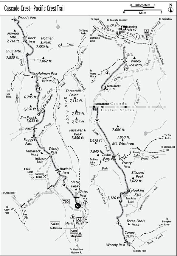
Miles and Directions
0.0Slate Peak PCT Trailhead.
3.5Trail crosses through Windy Pass and enters Pasayten Wilderness.
4.1Trail crosses high col behind Tamarack Peak.
5.0Foggy Pass.
5.5Jim Pass.
7.3Devils Backbone. Bear left.
7.6Trail crosses headwaters of Shaw Creek.
13.0Holman Pass. Junction with Deception Pass and Holman Creek Trails. Continue straight ahead.
16.2Rock Pass.
18.0Junction with Rock Creek Trail. Bear left.
18.5Woody Pass.
21.3Crest of Lakeview Ridge.
22.0Devils Stairway.
23.2Spur trail to Hopkins Lake. Bear left.
23.5Hopkins Pass. Spur trail descends to camp. Continue straight ahead.
25.7Junction with trail to Frosty Pass. Turn left.
25.9Castle Pass. Junction with Three Fools Trail. Continue straight ahead.
29.7Monument 78. Trail enters Manning Provincial Park.
30.3Monument 78 Camp. Turn left at corral and cross Castle Creek.
33.4PCT Camp.
33.6Junction with Frosty Mountain Trail. Bear right.
34.2Old Windy Joe Mountain Road. Turn left.
36.9Junction with Similkameen River Trail. Stay on old road and cross Similkameen River.
37.2PCT trailhead on BC 3.