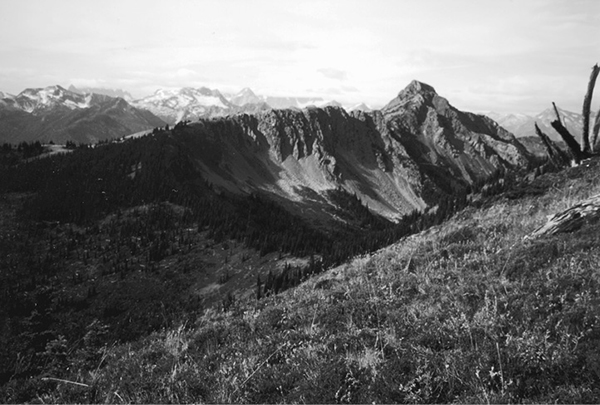
Skagit Peak from the Three Fools Trail
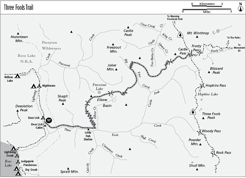
57 Three Fools Trail
An extended trip from Lightning Creek to Castle Pass, 17.6 miles overall.
Best season: Late July to mid-October.
Elevation gain: 7,161 feet (west to east).
Elevation loss: 4,101 feet (west to east).
Maximum elevation: 6,635 feet.
Topo maps: Skagit Peak, Castle Peak; Jack Mountain.
Jurisdiction: Pasayten Wilderness (Okanogan National Forest).
Finding the trailhead: The western end of the trail is reached via a 10.3-mile trek from Hozomeen on the Lightning Creek Trail. The east end is easiest to reach via a 10.8-mile trek from Manning Provincial Park in Canada on the Pacific Crest Trail (PCT).
The Hike
This primitive trail links Ross Lake with the spectacular high country of the Cascade Crest. It lies almost entirely within the Pasayten Wilderness and is sought out only by a few travelers who seek solitude on a long and challenging trek. Expect blow-downs in the timbered low country, and route-finding challenges as the trail crosses overgrown alpine meadows. The Elbow Basin Fire of 1996 burned 3,687 acres of timber in the Castle Fork of the Three Fools drainage, but it burned across only about 10 percent of this route.
According to local legend, Three Fools Creek and the peak of the same name were named in honor of three prospectors who were convinced by claim jumpers to abandon their claim along Ruby Creek to pursue rumors of a new strike on the streams along the Canadian border. Their ill-fated venture is reflected in the names of local landmarks: Blizzard Peak, Freezeout Creek, and Nightmare Camp.
The trek departs from the Lightning Creek Trail just north of Deer Lick Cabin and climbs gently as it makes its way around the base of Skagit Peak to enter the Three Fools Creek valley. The forest here is regenerating after a massive wildfire that leveled it in 1926. The trail then glides down to reach the banks of Three Fools Creek, a roaring torrent that churns down a wide and rocky channel between heavily forested banks. A few stark cliffs rise above the path, and from time to time there are openings in the trees where dense brush clogs the trail. After 3.1 miles, a spur path runs to Little Fish Shelter, which occupies a gloomy streamside clearing.
The main trail swings uphill, beginning its ascent of Skagit Peak. Upon reaching the mouth of the Elbow Creek valley, it begins to zigzag upward through a sparse woodland of Douglas fir. There are plenty of openings on the way up, with southward views up Grizzly Creek. The trail climbs doggedly up the ridgeline, finally breaking out of the forest high above Elbow Creek. At the top of the switchbacks are views of Spratt Mountain and the other rugged peaks that line the Three Fools watershed. The path now turns north, climbing steadily above the edge of an old burn to reach the low saddle behind Skagit Peak. The saddle reveals vistas of Skagit Peak’s rugged north face, and the stark crag to the north is Hozomeen Mountain.
The path swings onto south-facing slopes to bypass the next high summit, then ascends into a narrow col above Freezeout Lake. The barren summit that rises to the northeast is Freezeout Mountain. A healthy climb leads to the ridgetop above the lake. This is the highest point on the trail, with views to match. To the south, Nohokomeen Glacier is now visible on the north face of Jack Mountain; beyond it lie the heavily glaciated summits of the Colonial Peak massif. Looking westward, the sawtooth spires of the Picket Range rise beyond Mount Prophet, and farther north are the cloud-scraping summits of the Mox Peaks, Mount Redoubt, and Mount Spickard.
Skagit Peak from the Three Fools Trail
The trail soon drops onto southern slopes once more, making for a meadowy saddle where a small spring affords a rare opportunity to take on water. The path then crosses the vast alpine meadows above the Elbow Basin, traversing the slopes to reach a low pass at its head. Eastward views now encompass the summits of the Cascade crest. From south to north, the major summits are Shull Mountain, Powder Mountain, Three Fools Peak, Blizzard Peak, and Mount Winthrop. The first good look at timber that burned during the Elbow Basin Fire can be had at this point.
The path then drops into the steep and nameless drainage to the east for the long descent to Big Face Creek. After a short distance, a forgotten trail runs north to a lookout site above Welcome Basin. The main trail continues down, and the anemones of the upper slopes give way to clumps of brush farther down. The trail ultimately drops into heavy timber before entering the Big Face valley. Big Face Creek occupies a spectacular basin, bounded to the east by vast, grassy slopes and to the west by the sharply inclined sedimentary layers of Joker and Freezeout Mountains. The trail traverses the western wall of the valley to reach a shallow ford of the creek in the midst of an open meadow. There is a good camping spot in grove of old spruce and fir at the meadow’s north edge.
The trail passes this camp and follows the creek upward, becoming faint and overgrown with salmonberry in places. Upon drawing even with Joker Mountain, the path embarks on a hearty climb, zigzagging straight up the steep slopes to the east. The brush gives way to grassy swaths interfingered with stands of subalpine fir. At the top of the grade, the trail swings south for a long traverse across flowery grasslands. Ahead, the distant peaks of Ragged Ridge are mantled in glaciers, and can be seen between Crater Mountain and the northern horn of Jackita Ridge.
Upon gaining the ridgetop, the trail follows the crest of the divide, where once again there is evidence of the Elbow Basin Fire. After an initial descent the path surmounts two bald knolls that command spectacular views in all directions. Rugged peaks line the eastern horizon, the lone summits of Mount Ballard and Jack Mountain rise to the south, and the Picket Range crowds the far horizon to the west. As the trail makes its way down to the saddle at the head of Castle Creek, views of Freezeout Mountain, Castle Peak, and Frosty Mountain open up to the north.
The trail then swings across burned-over slopes that face southward, and the grassy glades between the snags yield the trail’s finest views of the Cascade crest. After descending around a grassy bowl, the path drops into a low col above Queen Creek. Look back as the trail climbs away from this saddle, since a striking frieze of Freezeout Mountain and Castle Peak is presented here. The trail soon begins to descend, and before long it leaves the Elbow Basin burn for good. A loose subalpine forest yields farewell views of Jack Mountain and the peaks above the Castle Fork as the trail descends to meet the PCT at a poorly marked junction in Castle Pass.
Miles and Directions
0.0Junction with Lightning Creek Trail near Deer Lick Cabin.
0.8Trail leaves Ross Lake NRA and enters Pasayten Wilderness.
3.1Little Fish Shelter. Trail starts climbing.
5.7Top of switchbacks.
6.4Pass behind Skagit Peak.
7.1Trail reaches ridge above Freezeout Lake.
8.2Seasonal spring.
9.0Trail crosses divide to enter Big Face watershed.
11.9Big Face Creek crossing.
12.0Big Face Camp. Trail starts climbing.
13.5Trail reaches top of ridge.
16.1Pass above Queen Creek.
17.6Castle Pass. Junction with Cascade Crest segment of PCT.