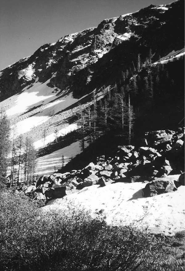
Isolated valley near Ferguson Lake
59 Ferguson Lake
A backpack to Ferguson Lake, 10.8 miles one way.
Best season: Mid-July to mid-October.
Elevation gain: 2,420 feet.
Elevation loss: 2,640 feet.
Maximum elevation: 6,990 feet at Slate Pass.
Topo maps: Slate Peak, Pasayten Peak, Mount Lago (trail not shown); Pasayten Peak, Washington Pass.
Jurisdiction: Pasayten Wilderness (Okanogan National Forest).
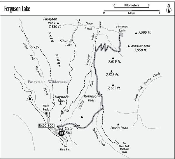
Finding the trailhead: From Washington Highway 20, follow Harts Pass Road to Harts Pass. Turn right onto Forest Road 5400-600 and follow it 1.8 miles to the Slate Pass trailhead, at the second switchback.
The Hike
This trek is beyond the range of day hikers but is a nice backpack into the Pasayten Wilderness for those interested in fishing and mountain scenery. The most direct path is via the trail that descends directly from Slate Pass to the Middle Fork of the Pasayten River, but the preferred route skirts eastward to take in Robinson Pass, vastly increasing the scenic value of the trip with less than a mile of additional hiking.
From the Slate Pass trailhead, follow the Buckskin Ridge Trail for the brief climb over the ridgetop. The trail descends into a meadowy bowl lined with talus slopes. Marmots are abundant here, and there are eastward views of Devils Peak and Robinson Mountain. At the bottom of the bowl, the trail skirts a copse of larches and a faint track runs eastward toward a nameless saddle. Turn right onto this trail, angling downhill across boulderfields, meadows, and timbered slopes to reach the broad, waterlogged lawns of the pass. Follow the cairns across the verdant swards of wildflowers to reach the far end of the gap, where the path angles northeast onto stony slopes.
The trail now descends across the sparsely timbered slopes of a nameless summit; some route-finding skills are helpful here since the trail is a bit faint in places. The loose woodland is interrupted frequently by shelves of bedrock, and there are fine views down the Robinson Creek valley, with Devils Peak presiding above its north side. After a rather gentle descent, hikers make a shallow ford of Robinson Creek, after which the trail climbs to join the Robinson Pass Trail.
Isolated valley near Ferguson Lake
Turn left as this well-beaten track climbs out of the old-growth subalpine firs and into a broad series of rolling alpine meadows. The path climbs moderately to reach the boggy flats of Robinson Pass, then descends on a northward tangent toward the Middle Fork of the Pasayten. During the descent, stands of fir alternate with lush avalanche slopes that offer westward views of Gold Ridge and Haystack Mountain. At the bottom of the grade, the cutoff trail from Slate Pass joins the main trail, which runs northward through a bottomland meadow and then treks 0.8 mile through the spruces to reach a junction with the spur trail to Ferguson Lake.
The old mule-killer trail to the lake has been rebuilt recently, and now a series of long switchbacks carries the trail upward across a broad snowslide path. The open slopes provide unobstructed views of Pasayten Peak and the lesser summits that line the ridge to the south of it. The trail gains most of its altitude on this sunny, west-facing slope, then turns the corner onto a timbered northern exposure.
The path traverses through subalpine forest to the mouth of a narrow, open valley that is guarded by a soaring edifice of stone. The old Eureka Creek Trail once departed from this spot, but it has long since disappeared. A shallow ford leads across the stream that issues from this picturesque vale, after which the path heads straight up the mountainside. After a brief but breath-stealing climb, the trail levels off to round an open ridge and drop into the floor of the cirque where Ferguson Lake lies beside grassy meadows. Its waters reflect the summit of Wildcat Mountain, and a strong population of rainbow trout offers fine angling possibilities.
Miles and Directions
0.0Slate Pass Trailhead.
0.1Slate Pass.
0.6Unmarked junction with faint trail to Robinson Creek. Turn right.
1.4Nameless pass into Robinson Creek drainage.
3.0Robinson Creek crossing.
3.2Junction with Robinson Pass Trail. Turn left.
5.1Robinson Pass. Trail descends toward the Middle Fork of the Pasayten River.
6.7Junction with cutoff from Buckskin Ridge. Continue straight ahead.
8.0Junction with Ferguson Lake Trail. Turn right.
9.7Trail crosses nameless stream at junction with old Eureka Creek Trail.
10.8Ferguson Lake.