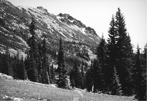
Devils Peak from Robinson Pass
60 Robinson Pass
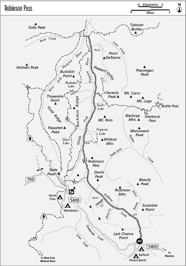
A long backpack from Harts Pass Road to Three Forks, 25.6 miles one way.
Best season: Early July to mid-October. The Beauty Creek waterfall is accessible by mid-May.
Elevation gain: 4,130 feet.
Elevation loss: 2,450 feet.
Maximum elevation: 6,220 feet.
Topo maps: Robinson Mountain, Slate Peak, Tatoosh Buttes, Mount Lago, Frosty Creek, Pasayten Peak; Pasayten Peak, Washington Pass.
Jurisdiction: Pasayten Wilderness (Okanogan National Forest).
Finding the trailhead: Take Washington Highway 20 to the Mazama cutoff road, 11 miles west of Winthrop. After a mile, there is a T intersection. Turn left, passing the Mazama general store. This is Harts Pass Road (Forest Road 5400), which is paved as far as the Lost River, about 5 miles. The Robinson Pass trailhead is on a short spur road at mile 7.
The Hike
This long trail links the West Fork of the Methow River with the forks of the Pasayten River. Most of the route is a long valley-bottom slog through the timber, but alpine meadows atop Robinson Pass and periodic avalanche slopes along the Middle Fork of the Pasayten yield fine mountain views. The roaring waterfall on Beauty Creek makes an excellent day-hike destination and is open in early summer when the high country is still locked in snow. The entire length of Robinson Creek can be hiked in a long day by starting at Slate Pass and following the initial stretch of the Ferguson Lake route to connect with the Robinson Pass Trail, then hiking down the valley to the Robinson Creek trailhead. (A car shuttle is required.)
The trek begins at the mouth of Robinson Creek as the trail runs north through a bottomland forest of Douglas fir and ponderosa pine that is typical of the dry side of the Cascades. After a short distance, the path climbs heartily up the mountainside to attain an altitude that is several hundred feet above the valley floor. A split waterfall is visible from the brushy slopes, and across the valley are the cliff bands of Scramble Point. The trail ultimately levels off, and the valley floor rises to meet it. The path crosses the Pasayten Wilderness boundary in a floodplain stand of cottonwood, Douglas fir, and cedar.
A bridge soon spans the rushing waters of Robinson Creek, offering the first views of Last Chance Point with its broad apron of talus and castellated crown of surreal spires and cockscombs. The trail crosses brushfields dominated by aromatic ceanothus bush, then reaches a stout bridge over Beauty Creek. A spectacular waterfall tumbles down the cliffs here, and a short distance beyond it an unmarked spur runs to the edge of a picturesque gorge chiseled into the stone by Robinson Creek.
The trail now continues upward through brushfields to reach a second bridge over Robinson Creek. On its way to Amey Creek, the path crosses avalanche scars that reveal the first views of Robinson Mountain. Watch for signs of massive rockfalls that have tumbled down from the sheer cliffs above the trail. Beyond Midnight Creek, the Douglas firs give way to Engelmann spruce, which attain old-growth proportions in the fertile soils of the bottomlands. An ankle-deep ford leads across Robinson Creek, and beyond it are campsites beside grassy avalanche scars. As the trail continues up the creek, outbreaks of spruce budworm have opened up the forest, allowing views of the small peaks that rise across the valley.
Devils Peak from Robinson Pass
A stand of old-growth subalpine fir surrounds the junction with a cutoff trail to Slate Pass. The main trail climbs gently onto vast and rolling slopes robed in verdant subalpine meadows. The stark cliffs of Devils Peak preside over endless swards of wildflowers as the trail makes its way to Robinson Pass. The pass itself is quite boggy, and scattered conifers are interspersed with wet meadows. Views from the pass encompass the valley of the Pasayten’s Middle Fork, with Slate Peak and Haystack Mountain rising above its headwaters.
A steady descent leads northward across the wall of the valley, and the trail bottoms out in a grassy meadow on the valley floor. Here, a cutoff trail runs southwest toward Slate Pass, and at the far edge of the clearing a well-beaten path leads to a riverside campsite. The trail then enters a scruffy forest of spruce, emerging 0.8 mile later at a junction with the Ferguson Lake Trail. Across the valley, timbered slopes rise to the rocky cockade of Pasayten Peak. Beyond this point, the forest becomes quite boggy, and gaps in the canopy admit shafts of sunlight into the understory. The path ultimately seeks the banks of the Middle Fork, and a number of campsites are sheltered beneath the streamside firs and spruces.
The path then swings away from the river, crossing a grassy slope beneath the rugged cliffs of Mount Rolo. The trees soon close in, masking views for several miles. Just before reaching Berk Creek, the spruces are replaced by lodgepole pines that grew in the wake of a massive wildfire that burned here. The Shellrock Pass Trail climbs away along the south side of Berk Creek, while the main trail continues its gradual descent along the edge of the valley. Along the way, avalanche paths reveal views of Buckskin Ridge, and groves of aspen grow in these sunny openings.
Beyond the stream that issues from Pleasant Valley, the mountains dwindle away into rounded foothills, and dense doghair stands of lodgepole pine shade the trail. A connecting trail departs from mile 22.4 to ford the Middle Fork and link up with the north end of the Buckskin Ridge Trail. The main path continues its forest trek, passing junctions with the defunct Point Defiance Trail and the Tatoosh Buttes Trail just before reaching the bridge that spans the Middle Fork to reach the Three Forks junction.
Miles and Directions
0.0Robinson Creek Trailhead.
1.0Trail enters Pasayten Wilderness.
1.2Trail crosses Robinson Creek and follows north bank.
2.9Trail crosses Beauty Creek below a large waterfall.
4.5Trail crosses Robinson Creek and follows south bank.
5.1Amey Creek.
6.1Midnight Creek.
6.8Trail fords Robinson Creek and follows north bank.
7.1Porcupine Camp.
9.1Junction with cutoff trail from Slate Pass. Continue straight ahead.
11.0Robinson Pass.
12.6Junction with cutoff trail from Buckskin Ridge. Continue straight.
13.7Junction with Ferguson Lake Trail. Bear left.
18.0Junction with Shellrock Pass Trail. Continue straight ahead.
18.1Trail crosses Berk Creek.
20.8Trail crosses stream that drains Pleasant Valley.
22.4Junction with ford trail that leads to Buckskin Ridge. Stay right.
23.5Junction with abandoned Point Defiance Trail. Bear left.
25.1Junction with Tatoosh Buttes Trail. Bear left.
25.6Bridge at Three Forks junction.