
Lake Mountain from Pistol Pass
62 Monument Trail
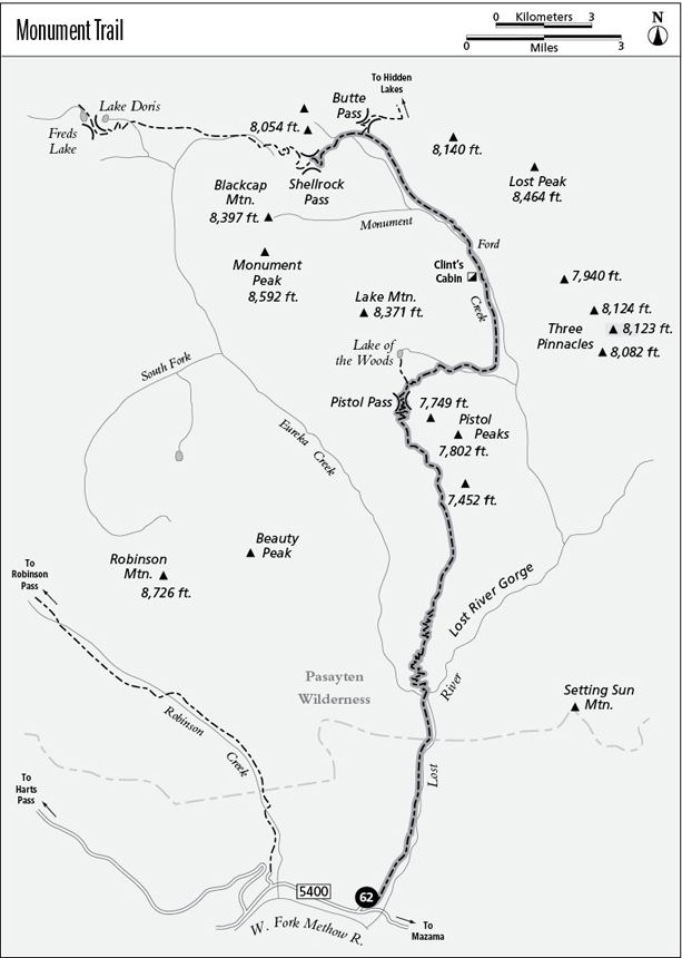
A day hike to the Lost River Gorge overlook (11.8 miles round-trip) or a long backpack to Lake of the Woods (12 miles) or Shellrock Pass (19.1 miles).
Best season: Late July to mid-October.
Elevation gain: 8,130 feet.
Elevation loss: 3,130 feet.
Maximum elevation: 7,500 feet at Shellrock Pass.
Topo maps: McLeod Mountain, Robinson Mountain, Lost Peak, Mount Lago; Washington Pass, Mazama, Billy Goat Mountain, Pasayten Peak.
Jurisdiction: Okanogan National Forest, Pasayten Wilderness.
Finding the trailhead: Take Washington Highway 20 to the Mazama cutoff road, 11 miles west of Winthrop. After a mile, there is a T intersection. Turn left, passing the Mazama general store. This is Harts Pass Road (Forest Road 5400), which is paved as far as the Lost River, about 5 miles. The spur road to the Monument trailhead is 0.2 mile beyond the Lost River.
The Hike
This trail penetrates deep into the heart of the Pasayten Wilderness, first following the Lost River then running along the arid ridgetops northward to the headwaters of Monument Creek. The divide between Eureka Creek and the Lost River burned in 1986, and the trail has received scant maintenance after that point. The trailbed is in fine shape, however, and seasoned backcountry visitors will be able to find the way without much difficulty. A high overlook of the Lost River Gorge makes a good day hiking destination. Backpackers are advised to carry an overabundance of water if they approach the trail from the south; there is no surface water along the rigorous climb from Eureka Creek to Lake of the Woods, a distance of 8 miles.
The journey begins with a level trek along the timbered benches west of the Lost River. The forest here is a mixture of ponderosa pine and Douglas fir. Both trees are well-adapted to the periodic droughts and fires that are so common on the east slope of the Cascades. About halfway to Eureka Creek, the benches give way to steep talus slopes that reveal the river and the foothills that surround it. Upon entering the Pasayten Wilderness, the trail drops to the river bottoms, where water-loving deciduous trees, such as cottonwood and western birch, are favored by frequent floods. The approach ends at the confluence of Eureka Creek and the Lost River, both of which emerge from impenetrable gorges. A stout bridge over Eureka Creek leads to the toe of the ridge that divides the valleys. There are good camping spots beyond the bridge on a spur path that leads down to the riverbank.
The main trail now begins its long and waterless grade to Pistol Pass. It initially zigzags upward across rocky and fire-prone slopes, climbing at a moderate but steady clip. There are fine views en route, featuring the mouth of Eureka Creek canyon as well as Mount Gardiner to the south. On the upper slopes of the ridge, bedrock and talus give way to grassy savannahs, and soon the glacier-clad summit of Silver Star Mountain peers out above intervening ridges to the south. Upon reaching the ridgetop, the trail arrives at a rocky overlook that commands good views of the Lost River Gorge. Day hikers should turn around at this point.
The path follows the ridgeline to the base of the next summit, then zigzags up to the level ridgetop beyond. Ever-expanding views now encompass the bald summits of the Lost River divide, Monument Peak to the north, and unobstructed southward views of Silver Star Mountain. A tableau of spires and pinnacles crowds the southwestern horizon.
Lake Mountain from Pistol Pass
Blow-downs cease to be a problem as the path enters the older burn below the southernmost of the Pistol Peaks. The path drops onto the western slope of the ridge, where a sparse, post-fire growth of spruce, fir, whitebark pine, and larch allows superb views of Beauty Peak beyond the Eureka Creek valley. The trail undertakes small-scale climbs and descents as it works its way across the mountainside, then zigzags up a short but tiring pitch to reach Pistol Pass. From here, the striking summit of Lake Mountain rises above a small pool known as Lake of the Woods, and the barren summits of Lost Peak and the Three Pinnacles rise beyond the deep basin of Monument Creek.
The trail then zigzags down into the larch-filled basin below with views of the Pistol Peaks along the way. On the floor of the bowl, a signpost marks the faint spur path that runs westward to Lake of the Woods. A 10-minute side trip leads to the shore of this shallow pool, surrounded by a youthful forest of larch and fir. Meanwhile, the main trail glides gently to the floor of the basin, crossing a series of ponds and watercourses that dry up in late summer.
Upon leaving the basin, the path snakes down to the stream that drains Lake of the Woods, the first reliable water source since Eureka Creek. The trail drops steeply along its south bank, then crosses the stream and continues its rapid descent along the far bank. The firs and whitebark pines of the subalpine zone give way to a montane forest of lodgepole pine. The trail eventually swings north into the valley of Monument Creek, angling downward to the valley floor. It then runs upstream along wooded benches to reach the ruins of Clint’s Cabin, which was built by trapper Clint Hanks. The cabin site is a good spot to camp, and a side trip down to the creek reveals interesting outcrops lining the watercourse.
Just above the cabin, a shallow ford leads across Monument Creek, and the trail continues its journey through grassy parks where aspens grow. The lodgepoles soon return, and through their boughs one can see the craggy cliffs that stretch between Lake and Blackcap Mountains. As Monument Creek splits into two forks, the trail follows the more northerly branch toward Butte Pass. Views are hidden by an intervening ridge as the path works its way up through sills of bedrock that are robed in heather and studded with a sparse growth of subalpine fir.
After passing a marked junction with the Butte Pass Trail, the main route swings westward. A rocky spur of Mount Lago rises ahead as the trail wanders through grassy glades. It soon strikes a sparkling brook, replete with waterfalls and lined with mosses and bog gentians. The path follows this stream up into a pure stand of subalpine larch, which soon opens up at a beautiful mere at the base of the peaks. The trail grows faint as it continues westward through lush meadows and stands of young larch; follow the cairns that lead gently upward into the rocky saddle to the south. There are superb eastward views of Lost Peak and Rampart Ridge as the trail tops the saddle. It then swings north across the talus to reach Shellrock Pass, where it becomes the Shellrock Pass Trail.
Miles and Directions
0.0Monument Trailhead. Trail follows the Lost River.
4.0Trail crosses Eureka Creek to reach campsite on Lost River. Bear left.
5.9Overlook with view of Lost River Gorge.
11.1Pistol Pass.
11.6Junction with trail to Lake of the Woods (0.4 mile, moderate). Bear right for Monument Creek.
12.6Trail crosses stream that drains Lake of the Woods.
13.7Trail bottoms out in valley of Monument Creek.
15.0Clint’s Cabin.
15.2Monument Creek ford.
17.8Junction with trail to Butte Pass. Bear left for Shellrock Pass.
18.2Basin below Shellrock Pass.
19.1Shellrock Pass.