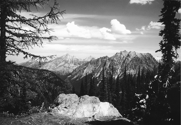
Looking south from Heather Pass
64 Maple Pass Loop
A half-day hike to Lake Ann (3.8 miles round-trip) or a longer day hike around the loop, 7.2 miles overall.
Best season: Late July to early October.
Elevation gain: 2,185 feet.
Elevation loss: 2,185 feet.
Maximum elevation: 6,950 feet above Maple Pass.
Topo maps: Washington Pass, Mount Arriva; Washington Pass, Mount Logan.
Jurisdiction: Okanogan National Forest.
Finding the trailhead: The trail departs from the Rainy Pass picnic area at mile 157 on Washington Highway 20.
The Hike
This trail climbs from Rainy Pass to the much higher divide that runs west from Frisco Mountain. Both Rainy Lake and Lake Ann can be reached via short side trips from the loop, and adventurous hikers can try to trace the faint path from Heather Pass to Lewis Lake, which lies at the base of Corteo Peak. From the windswept alpine tundra of Maple Pass, there are fantastic views of jagged peaks in all directions. A new trail along the ridge that separates Lake Ann from Rainy Lake permits a loop trip that takes half a day for a strong hiker to complete.
From the parking lot at Rainy Pass, the trail zigzags upward through mature subalpine forest. The path soon turns south, traversing around the edge of a small cirque. Several avalanche paths face eastward toward the sharp spires of Stiletto Peak. Talus slopes soon drop away into the grassy floor of the basin, where marmots are often spotted among the boulders. As the path traverses onto the south wall of the bowl, sparsely timbered slopes offer excellent northward views. From right to left, the prominent summits are Whistler Mountain, Cutthroat Peak, and Tower Mountain.
The trail then strikes Lake Ann’s outlet stream at a fine waterfall and follows it into a hanging valley carved by glaciers. The spur path to Lake Ann soon descends to the left. It runs through the timbered lower reaches of the basin, then breaks out into open country dotted with snowmelt ponds and wet meadows. Look backward as you approach the lake for views of the Early Winters Spires. The lake itself is bordered by low but rocky peaks that bear several small waterfalls down into the basin. Anglers will find fair fishing for undersize cutthroat trout.
Looking south from Heather Pass
Meanwhile, the trail to Maple Pass climbs gently but steadily through an ever-thinning forest. Emerging onto the slopes of a rocky spur, it reveals excellent aerial views of Lake Ann, with its footprint-shaped island. The gradient increases to a moderate ascent as the path reaches the lush meadows below Heather Pass. They are filled with wildflowers beyond counting; some of the more showy blossoms belong to aster, lupine, speedwell, phlox, columbine, and pink monkeyflower. An old trail climbs through the pass and continues west toward Lewis Lake, while the main route follows a newer track that surmounts a larch-studded outcrop overlooking the pass. From here, the tawny summits of the Pasayten country stretch away to the north, while to the west the turquoise waters of Wing Lake sparkle beneath the towering countenance of Black Peak.
The trail continues upward through the heather, charting a course high above Lake Ann. It crests the rounded divide at Maple Pass, with spectacular views all around. To the west, the towering summit of Corteo Peak rises above a cirque, flanked by Mount Benzarino to the left and Black Peak to the right. Far to the southwest are the glacier-mantled summits of Dome and Old Guard Peaks, with the icebound cone of Glacier Peak rising in the distance. Watch for white-tailed ptarmigan as the trail turns southward and climbs along the ridgeline toward the rugged peaks of Frisco Mountain. It tops out on the high prominence above Lake Ann, then turns east to follow a spur ridge downward.
The barren, rocky country of the high alpine zone is soon replaced by lush meadows, and hikers get views of a deep-blue tarn in the hanging basin below. Jumbled spires rise to the east, and to the west are continuing views of Black and Corteo Peaks. As the path continues down the ridge, it reveals a superb vista of Lyall Glacier, which unleashes its meltwaters to feed the magnificent waterfall that plunges to the turquoise waters of Rainy Lake.
The scattering of subalpine larches and whitebark pines soon gives way to a ragged woodland of mountain hemlock, gladed with swards of heather. The trail now plummets down the spine of the ridge, zigzagging downward as the mountain views dwindle into sporadic glimpses of peaks. Nearing the bottom of the grade, the path enters a lush forest. It joins the Rainy Lake Trail at a marked junction; turn right for the 0.3-mile side trip to Rainy Lake, or left for 0.7 mile of paved trail that leads back to Rainy Pass.
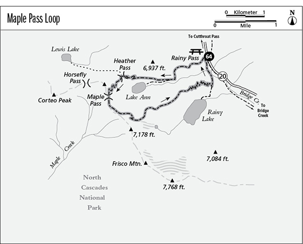
Miles and Directions
0.0Rainy Pass Day-use Area. Follow Maple Pass Trail.
1.4Junction with trail to Lake Ann (0.5 mile, easy). Bear right for Maple Pass.
2.9Heather Pass. Old trail runs east to Lewis Lake.
3.6Maple Pass.
6.8Junction with paved Rainy Pass Trail (0.4 mile to lake, easy). Turn left to complete the loop.
7.2Trail returns to Rainy Pass Day-use Area.