65 Cutthroat Lake and Cutthroat Pass
A short day hike to Cutthroat Lake (2.8 miles round-trip) or a longer day trip or short backpack to Cutthroat Pass (11 miles round-trip).
Best season: Late June to mid-October for the lake; mid-July to early October for the pass.
Elevation gain: 410 feet to the lake; 2,265 feet to the pass.
Maximum elevation: 6,815 feet at Cutthroat Pass.
Topo maps: Washington Pass (trail not shown); Washington Pass.
Jurisdiction: Okanogan National Forest.
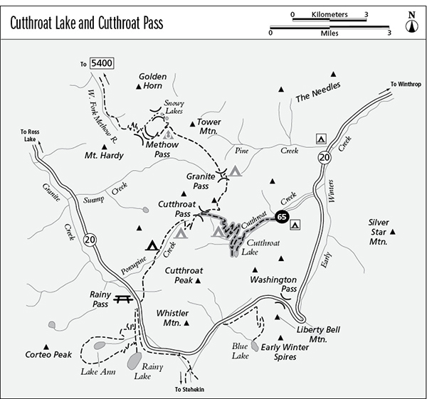
Finding the trailhead: From Washington Pass, drive east on Washington Highway 20 for 4.5 miles to Cutthroat Creek Road. Follow this paved road west for 1.5 miles to reach the trailhead and camping area at its end.
The Hike
This wide and well-engineered trail makes an easy day hike to the lake. Because the sensitive heather parks that line the lakeshore are extremely susceptible to damage, camping is forbidden within 0.25 mile of the shoreline. Hikers who seek a more challenging trek can follow the steady but moderate grade that climbs to the crest of the divide at Cutthroat Pass. Here, the trail intersects the Pacific Crest Trail (PCT) just 4 miles north of Rainy Pass.
The trek begins by crossing a bridge over Cutthroat Creek and climbing gently through an open woodland of Douglas fir and lodgepole pine. This entire valley burned long ago, and the resulting forest is comprised of fire-resistant or fire-dependent plant species. All along the way are fine views of the tawny crags of sedimentary rock that line the valley. As the trail continues upward, it passes through several isolated groves of spruce that were spared by the blaze. The groves reveal the pre-fire forest community that once covered the valley floor.
After 0.9 mile of traveling, the first spur path to Cutthroat Lake leads westward across hummocky parks to the eastern shore. A short distance farther, the main trail splits and the left fork leads to the north shore of the lake. Ringed by an open woodland of mountain hemlock and subalpine larch, the green waters of Cutthroat Lake are guarded on two sides by rugged mountains, the tallest of which is Cutthroat Peak. The lake is quite shallow, and as it fills with silt, meadows take over where fish once swam. Anglers will find fair fishing for pan-size trout.
Miles and Directions
0.0Cutthroat Lake Trailhead.
0.1Bridge over Cutthroat Creek.
0.9Junction with spur trail to east shore of lake (0.5 mile, easy).
1.3Spur trail to outlet of lake. Bear right for Cutthroat Pass.
4.4Camping area in larch-filled basin.
5.5Cutthroat Pass. Trail joins Granite Pass section of Pacific Crest Trail.
Cutthroat Pass Option
From a junction on the north shore of Cutthroat Lake, this trail makes two stream crossings as it begins a long series of gentle zigzags that carry it up the north wall of the valley. Through thinning forest, hikers get constant views of the surrounding peaks and sporadic glimpses of Cutthroat Lake. Near the top of the initial grade, the spires of Silver Star Mountain appear to the south above the intervening ridge.
At the top of the hill, the trail winds into a flat basin where subalpine larch are the dominant conifers. The strong winds at timberline rake the trees during winter, breaking off the topmost twigs so that the larches are prone to top-kill. When the dominant bud at the top of the tree breaks off, buds on the lateral branches are released from inhibiting hormones and start to grow vertically, competing to become the new dominant branch. There are excellent campsites in this basin, but surface water is unavailable from midsummer onward.
The path climbs onto the timbered slope to the east of the basin, passing among mountain hemlocks and subalpine firs. These slopes offer the finest views of Cutthroat Lake. The path soon navigates among rounded slabs of granite interspersed with swards of heather and dwarf blueberry. Watch for golden-mantled ground squirrels, which are abundant here. The trail rounds a shallow bowl to reach the crest of the divide, where it ends at a junction with the Glacier Pass segment of the PCT. The tops of the Early Winters Spires can now be seen to the south above an intervening ridge. To the west are views down Porcupine Creek toward the glacier-bound summits of Black and Corteo Peaks.