66 Granite Pass Highline—Pacific Crest Trail
A day hike to Granite Pass, 15 miles round-trip, or a backpack to Methow Pass, 10.5 miles one way.
Best season: Early August to early October.
Elevation gain: 2,970 feet.
Elevation loss: 1,240 feet.
Maximum elevation: 6,980 feet above Granite Pass.
Topo maps: Washington Pass (trail not shown); Washington Pass.
Jurisdiction: Okanogan National Forest.
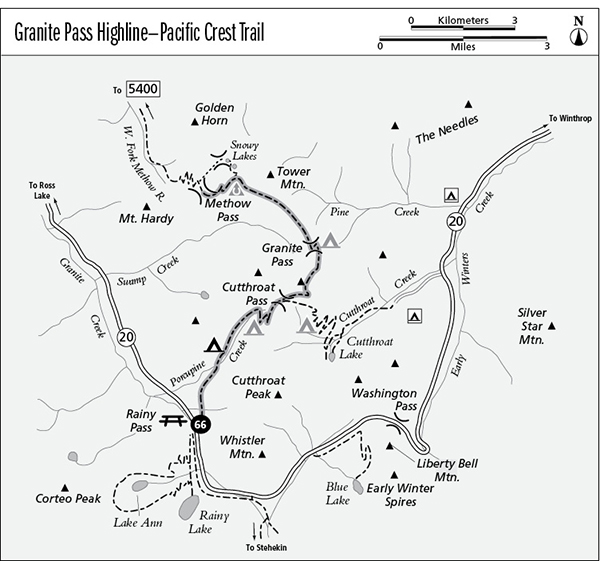
Finding the trailhead: The trail departs from the Pacific Crest Trail North trailhead, directly across the highway from the Rainy Pass picnic area at mile 157 on Washington Highway 20.
The Hike
This segment of the Pacific Crest Trail (PCT) climbs high among the barren ridgetops and soaring granite spires north of Rainy Pass, staying above timberline for a high traverse to Methow Pass. The heights above Granite Pass are the highlight of the trip, offering staggering views of The Needles, a collection of fanglike spires of the Golden Horn granite. The Snowy Lakes make a popular side trip for this trail, accessed by way trails from either side of Methow Pass. Travelers following the PCT will continue northward, following the West Fork of the Methow and Trout Creek Divide routings to reach Harts Pass.
From the PCT North trailhead at Rainy Pass, the trail runs northward across heavily timbered slopes. After passing a pretty woodland waterfall, the path crosses an open slope that offers the first views of the surrounding mountains. The path returns to the trees for the trek to Porcupine Creek, which is spanned by a footbridge. There is a small tent pad beside the bridge. The trail follows the stream upward into a sparsely wooded basin, with fine views of Cutthroat Peak along the way. Upon reaching the headwaters, the trail arcs upward above the treeline. It passes a well-developed camping area as it crosses the many rills that form Porcupine Creek.
Bidding farewell to a sparse growth of larches, the trail climbs into alpine country of heather and granite. The trail reaches the divide at Cutthroat Pass, where a spur trail drops away to the east toward Cutthroat Lake. The main trail climbs gently on an easterly heading, passing through a landscape with huge boulders and twisted trees like those of an Oriental garden. Views are outstanding as the path reaches the tip of a steep spur ridge, with Cutthroat Lake lying in the basin below like a giant emerald and the pinnacles of Kangaroo Ridge and the Early Winters Spires rising above the ridgetops to the south. A hidden and waterless tent pad lies just above the trail at this point.
The path now runs north across barren slopes of broken rock, an alpine desert where only phlox and penstemon grow. Snowslips linger late into the summer here; carry an ice axe at all times. Silver Star Mountain can be seen to the southeast, buttressed by the craggy jawbones of Vasiliki and Snagtooth Ridges. The trail soon passes above a high saddle that marks the edge of the Pine Creek watershed. As the trail descends toward the much lower gap of Granite Pass, there are inspiring views of The Needles rising beyond the headwaters of Pine Creek. Glacier Pass lies at the head of the glacier-carved trench now occupied by Swamp Creek. The sparsely wooded dells of the pass offer sheltered camping spots.
The trail now swings westward, descending briskly before beginning a high traverse of the Swamp Creek valley wall. The steep slopes are sparsely timbered with spindly firs and hemlocks. The majestic summits of Black and Fisher Peaks are framed by the valley’s mouth, and a tall but nameless peak rises above the far side of the abyss. Minor ups and downs lead to a pocket basin high above the valley floor. There is a horse camp here, and a way trail ascends northward to the spectacular Snowy Lakes, which occupy the alpine shelf between Tower Mountain and the Golden Horn.
After passing the basin, the main trail climbs a bit, then traverses across to the larch-bordered meadows of Methow Pass. The lack of water makes this pass a poor place to pitch a tent. The trail along the West Fork of the Methow River rises into the pass from the north, a continuation of the PCT.
Miles and Directions
0.0PCT North Trailhead.
1.9Trail crosses Porcupine Creek.
3.8Upper Porcupine camp.
5.0Cutthroat Pass. Junction with trail to Cutthroat Lake. Turn left.
5.8Campsite on rocky spur.
6.9Trail reaches heights overlooking Granite Pass.
7.5Granite Pass.
9.5Snowy Lakes horse camp.
10.5Methow Pass. West Fork Methow Trail runs northward.