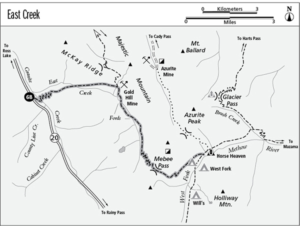
68 East Creek
A day hike to the Gold Hill Mine, 8.8 miles round-trip, or a backpack to the West Fork Methow Valley, 11 miles one way.
Best season: Mid-July to early October.
Elevation gain: 4,270 feet.
Elevation loss: 2,420 feet.
Maximum elevation: 6,700 feet at Mebee Pass.
Topo maps: Azurite Peak, Slate Peak; Mount Logan.
Jurisdiction: Okanogan National Forest.
Finding the trailhead: The trail begins at the East Creek Trailhead, mile 144 on Washington Highway 20 (13 miles west of Rainy Pass).
The Hike
This mostly forgotten trail offers a challenging trek from WA 20 to the headwaters of the West Fork of the Methow River. Along the way are several features of historical note, including the Gold Hill Mine and ruins of an old fire lookout above Mebee Pass. The early stretches of the trail have been rebuilt, and it is easy to follow as far as the Gold Hill Mine. Beyond this point, expect route-finding challenges; the trail over Mebee Pass receives low maintenance priority and is tough to follow in places.
From the parking area, the trail drops sharply to cross a stout bridge over Granite Creek. It then turns east, following the stream through shady bottomlands. After a brief ascent along the stream, the path climbs briskly onto slopes that burned in a 1926 fire. The forest along the creek held more moisture and escaped the worst of the blaze; old Douglas firs were able to survive and reseed the area with their offspring. As the trail zigzags relentlessly upward, the forest becomes a pure stand of lodgepole pine so typical of burned-over sites in the drier parts of the Cascades. The trail climbs high onto the mountainside to avoid the stony gorge that guards the mouth of East Creek. During the ascent, bald knobs and a small talus field offer fine southward views of Beebe Mountain.
The trail then rounds the ridge onto the slopes above East Creek, climbing sporadically through a mossy forest of western hemlock. After a time, a steady descent leads down to the creek itself, and a footlog leads to the north bank. A streamside tent pad offers one of the few good camping spots along the route. The trail follows the stream eastward for a brief time, then climbs onto the slopes above. The southern exposure offers a drier microclimate, allowing Douglas fir to dominate the forest. As the path nears the Gold Hill Mine, feeder streams descend through brushy openings with final views of the peaks to the west.
The trail tops out at a junction with the Boulder Creek Trail. The ruins of the Gold Hill Mine are just beyond this intersection. A level pad of tailings bears the wreckage of collapsed structures and rusting mining equipment. The trail becomes faint beyond the mine site; cross the tailings and quarter downhill through the timber to reach a wide brushfield. The trail now runs straight downhill through the heart of the brush (follow flagging where possible). About halfway to East Creek, it crosses a tributary stream and continues downward along the eastern edge of the clearing. It levels off near the valley bottom, running eastward across two lesser avalanche slopes.
Upon reaching a grassy meadow, the path turns downhill again for a knee-deep ford of East Creek amid a riot of willows. It then climbs into the avalanche track on the south side and turns east for a short venture along the south bank. A loose forest of spruce and silver fir closes in around the trail, and soon a second ford leads back to the north bank. The trail now embarks on a long bottomland journey through forest. At the head of the valley, tidy avalanche paths interrupt the trees to reveal eroded ridges, stained yellow and orange by oxidizing metals in the bedrock.
The second snowslide slope is filled with wildflowers, and it marks the bottom of the grade to Mebee Pass. Short switchbacks lead steadily upward through a sparse subalpine woodland. Near the top of the grade, the trail enters the small alpine basin at the foot of the pass. Here, subalpine larch are scattered across slopes of heather and dwarf blueberry. The path zigzags up to Mebee Pass, overlooked to the north by a collection of daggerlike spires. Beyond the West Fork of the Methow River are the summits of Holliway Mountain and the Golden Horn. Adventurous travelers can scramble up the ridgeline to the north to reach the bleached ruins of a fire lookout that was built in 1934. From this lofty perch, hikers gain excellent views of the glaciers that adorn Ragged Ridge to the southwest.
From the pass, the main trail descends steeply into the basin beyond, then enters a heavy growth of mountain hemlock and levels off. Views open up again as the path strikes the western wall of the West Fork valley and angles down across its face. The imposing cliffs of Mount Hardy can now be seen above the head of the valley. The descent is rather steep at first but soon becomes moderate as stony highlands give way to wooded slopes. As the trail continues northward, spindly subalpine trees give way to a robust montane forest. Two avalanche slopes near the bottom of the grade allow final views of Holliway Mountain and Mount Hardy. The trail ends at an intersection with the West Fork of the Methow River Trail, just south of Horse Heaven Camp.
Miles and Directions
0.0East Creek Trailhead.
2.2 Footbridge over East Creek. Trail follows north bank.
4.4 Junction with Boulder Creek Trail. Bear right to cross Gold Hill Mine site.
4.8 Trail fords East Creek and follows the south bank.
5.2 Trail returns to the north bank.
6.9 Bottom of grade to Mebee Pass.
8.3 Mebee Pass.
11.0 Trail joins the West Fork Methow Trail near Horse Heaven Camp.