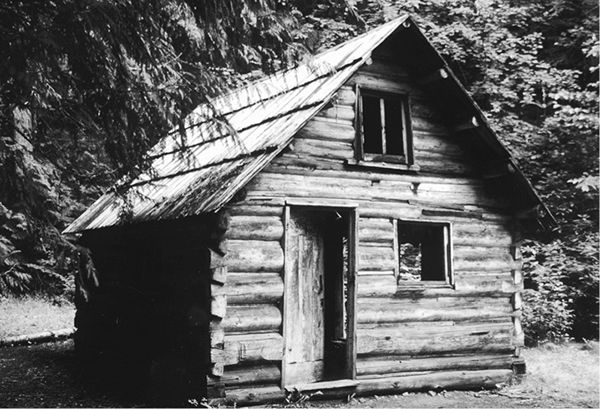
Cabin at the confluence of Canyon and Granite Creeks
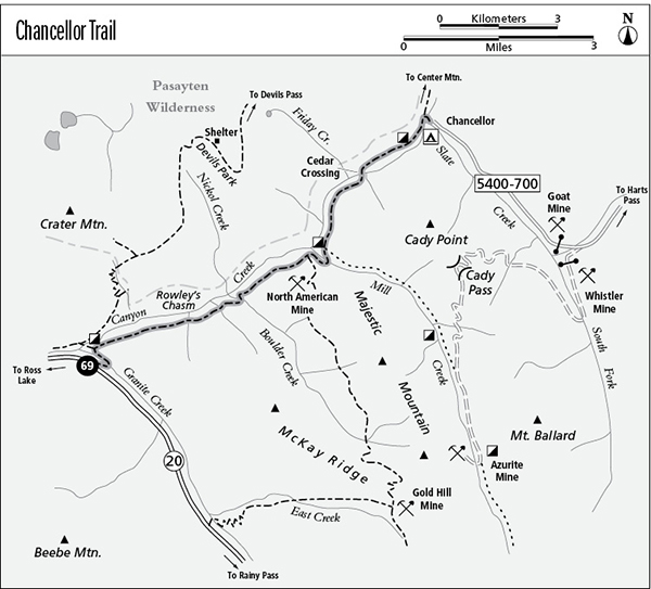
69 Chancellor Trail
A backpack along Canyon Creek from Washington Highway 20 to Chancellor Camp, 8.3 miles one way.
Best season: Late June to early November.
Elevation gain: 1,949 feet.
Elevation loss: 1,005 feet.
Maximum elevation: 2,855 feet.
Topo maps: Crater Mountain, Azurite Peak; Mount Logan, Jack Mountain.
Jurisdiction: Okanogan National Forest.
Finding the trailhead: The trail begins at the Canyon Creek Trailhead, at mile 141.2 on WA 20, 16 miles west of Rainy Pass.
The Hike
This route traces Canyon Creek through a historic gold-mining district to reach the old Chancellor Camp. Slate Creek Road, which once offered access to Chancellor, has been closed 5 miles short of the campground due to washouts. Watch for the old cabins of prospectors along the way. Mountain views are scarce here, but the upper stretches of the trail offer lots of solitude. As a result of flooding in 2003, portions of the Chancellor Trail between Boulder and Mill Creeks have been closed in recent years. Check at a ranger station for the most current conditions.
The trail begins by crossing a bridge over Granite Creek, then makes its way downstream to a junction with the Chancellor Trail. A short side trip on the trail straight ahead leads to an old miner’s cabin that guards the point where Granite and Canyon Creeks join to form Ruby Creek. This cabin was dismantled and moved to this spot in the 1930s by the Forest Service, and it served for a time as a guard station.
Meanwhile, the Chancellor Trail itself splits away to the northwest, climbing steeply to enter the Canyon Creek valley. The ascent becomes moderate as the trail makes its way across the steep and heavily timbered slopes. Near the top of the grade, gaps in the forest canopy reveal a pretty waterfall that tumbles down the flanks of Crater Mountain. After 1.9 miles, the trail descends a bit to reach the Rowley’s Chasm spur trail. A short distance down this side path is the spot where a bridge (since collapsed) once spanned a narrow cleft that dropped into a washed-out abyss. With slippery and uneven footing at the edge of the chasm, it is difficult to get a good view of the rift without endangering yourself.
Cabin at the confluence of Canyon and Granite Creeks
The main trail now levels off, with easy traveling through the cedar-hemlock woodland. Several gaps in the forest along this stretch allow pleasant views up and down the valley. After crossing Holmes Creek, the trail descends almost to the floor of the main valley to make its crossing of Boulder Creek. A steady ascent leads back onto the steep mountainsides for the moderate ascent to the mouth of the Mill Creek valley. Here, old trails run eastward, first the Boulder Creek Trail and later the Mill Creek route on the far side of the stream. The ruins of an old sawmill lie below the trail at this point, and there are campsites along the stream. The trail adopts an old narrow-gauge roadbed, constructed in 1895 to link the Barron Mine with the sawmill, which provided the timbers needed to brace mine passageways. A gentle ascent leads to a cliff-hanging overlook high above Canyon Creek. Looking straight down the valley, hikers can see the north face of Snowfield Peak mantled in the billowy folds of Neve Glacier.
The old roadbed now enters a loose woodland of Douglas fir, interrupted in several spots by steep talus slopes. Watch for waterfalls on the far side of the valley. The trail then descends gradually, and soon the Douglas firs are replaced by a dense and shady stand of young cedar and hemlock. The descent steepens to a foot-pounding pace as the trail makes its way to the bottomlands at Cedar Crossing, where a rickety bridge leads to the far bank of Canyon Creek.
The path now ascends gradually through brushy openings beside the streamcourse. Willow and alder crowd the trail, and patches of thimbleberry are quite dense in places. Just before reaching Chancellor Camp, the trail passes the two-story Converse Cabin, which was associated with placer mining activities near Chancellor. The path then runs beneath a broad swath of talus, while Canyon Creek rushes through a picturesque series of rapids. A junction with the Center Mountain Trail marks the spot where a bridge leads across Canyon Creek to the end of the trek at the camp.
Miles and Directions
0.0 Canyon Creek Trailhead.
0.1 Trail crosses Granite Creek and turns southwest.
0.2 Chancellor Trail splits away to the right.
1.9 Junction with old Rowley’s Chasm spur trail. Stay right.
2.2 Trail crosses Pete Miller Creek.
3.1 Junction with old Boulder Creek Trail. Continue straight ahead.
3.4 Trail crosses Boulder Creek.
5.4 Trail crosses Mill Creek.
5.7 Junction with abandoned Mill Creek Trail. Stay left.
6.8 Cedar Crossing. Bridge carries the trail to the west bank of Canyon Creek.
8.6 Converse Cabin.
8.2 Junction with Center Mountain Trail. Turn right to complete hike.
8.3 Trail crosses bridge over Canyon Creek to reach Chancellor Camp.