71 Trout Creek Divide—Pacific Crest Trail
A day trip to the Azurite Peak viewpoint, 8.8 miles round-trip, or a backpack to the West Fork of the Methow Trail, 10.6 miles one way.
Best season: Late July to early October.
Elevation gain: 1,005 feet.
Elevation loss: 3,125 feet.
Maximum elevation: 7,005 feet.
Topo maps: Slate Peak; Washington Pass.
Jurisdiction: Okanogan National Forest.
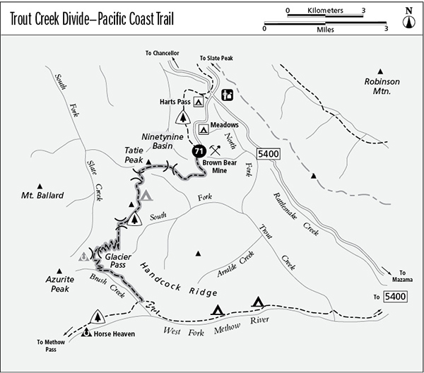
Finding the trailhead: From Washington Highway 20, follow Harts Pass Road toward Harts Pass. Just before reaching the pass, turn left onto Forest Road 5400-500, following signs for the Meadows Campground. Follow this improved gravel road for 2 miles to reach the trailhead at its end.
The Hike
This segment of the Pacific Crest Trail (PCT) follows high ridgetops southward from Harts Pass, yielding excellent views before it drops toward Glacier Pass. It then follows Brush Creek to the West Fork of the Methow River. The low divide known informally as Grasshopper Pass lies just across the valley from Azurite Peak, and its larch-studded meadows make an ideal destination for day hikers.
The trail begins above the old Brown Bear Mine, ascending moderately across a steep and rocky bowl. Marmots, pikas, and golden-mantled ground squirrels are abundant here, and a few subalpine larches rise from rocky moorings at the edge of the talus. The prominent massif to the east is Robinson Mountain. The upthrust strata of a rocky peak rise ahead, and the trail rises to surmount the ridgetop east of its summit.
Emerging high above the South Fork of Trout Creek, the trail offers a spectacular vista of the granite peaks of the Golden Horn batholith. Gardiner and Silver Star Mountains rise along the eastern edge of the Cascades, with The Needles to the right of them. The craggy spires of Tower Mountain and the Golden Horn are next in line, followed by the distant and snowy summits of Ragged Ridge. A low gap at the head of the South Fork basin reveals the stark summit of Azurite Peak with its permanent collar of snow.
The trail now embarks upon a high circuit of the basin, crossing flower-studded meadows and arid slopes of shattered stone. A nameless summit guards the head of the basin, and an anticline, or downwarping of the rock strata, can be seen clearly in its east face. A shallow grade leads up to a saddle above the Ninetynine Basin, with its rainbow-banded peaks guarding a collection of shallow ponds in the meadows far below. Views from this point encompass the barren summits of the Pasayten Wilderness stretching northward to the horizon. A gentle descent leads to a pass above the Slate Creek watershed, and a short side trip to the top of the divide yields a stunning perspective of Mount Ballard as well as a distant view of Jack Mountain.
The path now skirts the base of the next summit, passing through sparse stands of larch and crossing broad talus slopes. There are several camps in sheltered spots along the way, with lingering snowfields nearby to supply drinking water. On the far side of the peak, the trail rises onto the long ridgetop known to some as “Grasshopper Pass,” with its larch meadows and face-to-face views of Azurite Peak and Mount Ballard. The rusty tint on the ridge that links the two peaks is derived from the oxidation of iron-rich ores in the bedrock. Most day hikers turn around here.
The trail now winds southward, climbing a rugged ridgetop. Soon there are views of the Golden Horn and the nameless spires that guard distant Mebee Pass. Approaching its apogee, the path swings onto the west side of the ridge. It then begins a long descent to Glacier Pass, zigzagging down across steep and grassy slopes. These slopes play out into heather and fir parklands at the bottom of the grade, and small boulderfields provide habitat for pikas and marmots. After winding downward through subalpine forest, the trail finally reaches the level trough of Glacier Pass. There is a campsite in the trees beside the trail, but the horse camp occupies the prime location: a streamside meadow to the west beneath the gaze of Azurite Peak.
The trail soon drops into the Brushy Creek valley, where snowslides from towering cliffs have cleared the south side of the valley of all but the most supple shrubs. Enterprising beavers have been quick to exploit this mother lode of edible twigs; you can view their handiwork as the trail crosses talus slopes in the middle reaches of the valley. Pikas also live here, in the broken rock beside the trail. As the trail descends steadily across the north side of the valley, it enters tall brushfields of slide alder and mountain ash. The brush finally gives way to isolated stands of ancient spruce and Douglas fir at the mouth of the valley. Hikers gain parting glimpses of The Needles and Tower Mountain as the trail completes its final descent to the West Fork Methow Trail.
Miles and Directions
0.0 Trailhead. Connecting trail leads upward.
0.1 Junction with PCT. Turn left to begin hike.
0.7 Trail crosses divide to enter Trout Creek watershed.
4.4 Trail reaches divide opposite Azurite Peak.
6.3 Glacier Pass and camps.
10.6 Trail reaches junction with West Fork of the Methow River Trail.