Dagger Lake
72 Dagger Lake and Twisp Pass
A long day hike or short backpack to Dagger Lake, 12.1 miles round-trip.
Best season: Mid-July to mid-October.
Elevation gain: 4,628 feet.
Elevation loss: 3,124 feet to Twisp River Road.
Maximum elevation: 6,064 feet at Twisp Pass.
Topo maps: Washington Pass, McAlester Mountain, Gilbert; Washington Pass, Stehekin.
Jurisdiction: North Cascades National Park, Lake Chelan–Sawtooth Wilderness (Okanogan National Forest).
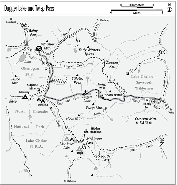
Finding the trailhead: The hike begins at the Pacific Crest Trail South Trailhead, at mile 159.2 on Washington Highway 20, 2 miles east of Rainy Pass.
The Hike
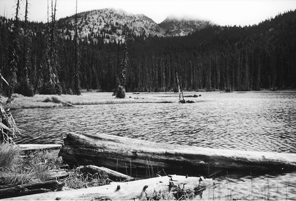
Dagger Lake is a shallow and weedy tarn at the edge of North Cascades National Park. Because it is easily reached in a short day’s backpack from the highway, the lake is a popular destination: Reservations for its two campsites fill up quickly on weekends and holidays. Dispersed camping is allowed without a permit east of Twisp Pass, within the Lake Chelan–Sawtooth Wilderness. This is steep country, though, and level camping spots with access to water are difficult to find.
From the Pacific Crest Trail (PCT) South trailhead, cross the highway and follow the main trail on a southeasterly heading. A moderate descent follows the highway through a forest of tall mountain hemlock. After a short distance, the PCT splits away to the right toward a bridge over Bridge Creek, while the trail to Dagger Lake veers left to continue along the east bank of the creek.
There is a fine Forest Service campsite as the trail crosses State Creek, and on the far side, a faint spur runs south to reach the ruins of an old drift mine on a bench above Bridge Creek. This type of mine comprises a vertical shaft sunk into loose alluvial gravels, shored up by timbers to prevent collapse. Once the shaft reached solid bedrock, where the heavy placer gold was concentrated, the richest deposit or “pay streak” was followed laterally by “drifting” horizontal shafts along the deposit of gold-bearing gravels until the paydirt petered out. An abandoned segment of the Bridge Creek Trail runs south from the mine site; the route to Dagger Lake follows the wider path that runs east from the junction above the mine.
The latter trail soon turns south at a junction with the Copper Pass Trail. A gradual descent through silver firs leads across the valley’s edge, and occasional brushfields yield glimpses of Frisco Mountain. Just beyond the national park boundary, the Stiletto Peak Trail climbs away to the left, while the main trail descends quickly into the gloomy spruce swamps of the Bridge Creek bottoms. After a shady trek, a broad avalanche slope offers views of a thin waterfall on the flanks of Frisco Mountain. The broad bottomlands give way to wooded hummocks and swales as the trail progresses down the valley. It eventually reaches a well-marked junction with the connector trail linking McAlester Lake and Bridge Creek trails via Fireweed Camp.
Dagger Lake
Turn left here as the Dagger Lake Trail begins a steady climb up the mountainside. After a long slog through Douglas fir woodland, the trail breaks out into a clearing filled with ceanothus bushes. To the south are views of the rocky peaks that line the head of the McAlester Creek valley. The path continues to climb, entering the valley of the East Fork of McAlester Creek. Initially it crosses snowslide tracks choked with alder, but later an unbroken forest of silver fir and spruce covers the mountainside.
The trail continues upward at a moderate pace and reaches the floor of an elevated basin. Here, runnels of clear water flow amid copses of mountain hemlock and heather-huckleberry parks. The manicured vegetation gives the effect of a Japanese garden, guarded by the soaring face of Hock Mountain. The woodland becomes more ragged as the trail glides upward to a spot above the north shore of Dagger Lake. The horse camp is above the trail here, while a spur path leads down to the hiker camp amid scattered spruces on the lakeshore. The marshy sedge flats around the water foster a burgeoning population of mosquitoes that are always biting, even when the smallish cutthroats that cruise the lake are not.
After passing the horse camp, the trail arcs upward, rounding the lake basin as it climbs steadily to the broad divide of Twisp Pass. Watch for marmots as the trail approaches the timberline. The trail leaves North Cascades National Park as it crosses the divide, and a faint way trail runs northward toward a high lake on the shoulder of Stiletto Peak. The main trail now descends into the Lake Chelan–Sawtooth Wilderness, crossing shelves of bedrock that alternate with brushy meadows. Lincoln Butte rises just to the north, and to the south is an ever-expanding panorama of the craggy peaks that guard the South Fork of the Twisp River.
The trail soon swings onto the eastern slopes of Lincoln Butte, descending more moderately across the open slopes covered alternately in brushfields and broken rock. The path enters a woodland of lodgepole pine as it nears the forks of the Twisp River. Upon reaching the confluence of the North and South Forks, the trail jogs westward as it descends to the North Fork, crossing the stream beside a junction with the Copper Pass Trail. Turn right as the route begins to descend more briskly across brushy slopes and through ragged stands of deciduous trees mixed with conifers. To end the trek, hikers can descend a steep pathway to reach Road’s End Campground, or can continue east on the main trail for another 0.6 mile to reach the North Creek Trailhead.
Miles and Directions
0.0 PCT South Trailhead. Cross highway to begin hike.
0.1 Junction with PCT inbound from Rainy Pass. Keep left.
0.8 Junction with Bridge Creek Trail. Turn left and cross State Creek.
0.9 Junction with old Bridge Creek Trail. Turn left.
1.0 Junction with Copper Pass Trail. Bear right.
2.0 Junction with Stiletto Peak Trail. Continue straight ahead.
3.3 Junction with trails to Fireweed Camp and McAlester Pass. Turn left.
6.3 Dagger Lake. Spur trail descends to hiker camp.
7.3 Twisp Pass. Trail leaves North Cascades National Park and enters Lake Chelan–Sawtooth Wilderness.
9.7 Trail crosses the North Fork of the Twisp River to join Copper Pass Trail. Turn right.
11.5 Road’s End Campground.
12.1 North Creek Trailhead.