
73 Stiletto Peak
A day hike to the timberline meadows on Stiletto Peak, 9.2 miles round-trip.
Best season: Mid-July to mid-October.
Elevation gain: 2,240 feet.
Elevation loss: 500 feet.
Maximum elevation: 7,400 feet at the old lookout site on the mountaintop.
Topo maps: Washington Pass, McAlester Mountain; Washington Pass, Stehekin.
Jurisdiction: Okanogan National Forest, North Cascades National Park.
Finding the trailhead: The hike begins at the Pacific Crest Trail South Trailhead, at mile 159.2 on Washington Highway 20, 2 miles east of Rainy Pass.
The Hike
This seldom-hiked trail climbs from the Bridge Creek valley to subalpine meadows high on the flanks of Stiletto Peak. The trail disappears above timberline, but ambitious hikers can navigate upward by dead reckoning to reach the clifftop perch that once was the site of a fire lookout on one of the western summits. The entire trek can be completed in a long day of hiking.
From the Pacific Crest Trail (PCT) South Trailhead, follow the Dagger Lake route along the east bank of Bridge Creek. The Stiletto Peak Trail leaves from a signpost just beyond the national park boundary, and zigzags upward through a mature forest of silver fir. There are brushy openings as the path crosses small watercourses, with westward views of Frisco Mountain. The forest becomes patchy as the trail gains altitude, and the openings are carpeted with huckleberry bushes.
The path eventually reaches dry, south-facing meadows that offer views of the many crags of Bowan Mountain. Continuing up into the subalpine zone, hikers can see the granite bones of the mountain begin to show through the veneer of vegetation. The lone summit of Whistler Mountain is now visible to the north, guarding Rainy Pass. As it nears the top of a level bench, the trail enters a series of lush meadows bedecked with wildflowers of all descriptions. The track is discernible for a short distance, then disappears in the midst of the meadows. The summit of Lincoln Butte is now visible to the east.
Adventurous hikers may follow the cairns upward, making a calf-burning climb to the mountaintop lookout site. Sheer cliffs drop away into the valley of Copper Creek, and all around are the jagged needles of the Golden Horn batholith.
Miles and Directions
0.0 PCT South Trailhead. Cross the highway to reach the trail.
0.1 Junction with the PCT inbound from Rainy Pass. Bear left.
0.8 Junction with trail that follows east bank of Bridge Creek. Turn left and cross State Creek.
0.9 Unmarked junction with old Bridge Creek Trail. Bear left.
1.0 Junction with Copper Pass Trail. Keep right.
2.0 Stiletto Peak Trail splits away from main trail. Turn left.
4.6 Trail peters out in subalpine meadows on shoulders of Stiletto Peak.
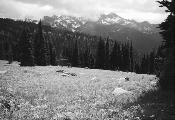
Meadows atop Stiletto Peak