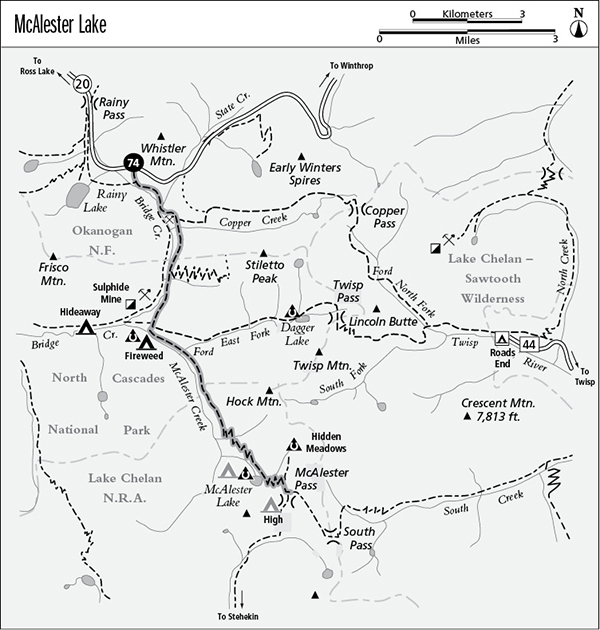
74 McAlester Lake
A long day hike or backpack to McAlester Lake, 15.1 miles round-trip, or a backpack to McAlester Pass, 8.5 miles one way.
Best season: Mid-July to mid-October.
Elevation gain: 2,230 feet.
Elevation loss: 790 feet.
Maximum elevation: 6,000 feet at McAlester Pass.
Topo maps: Washington Pass, McAlester Mountain; Washington Pass, Stehekin.
Jurisdiction: North Cascades National Park, Lake Chelan National Recreation Area.
Finding the trailhead: The hike begins at the Pacific Crest Trail South Trailhead, at mile 159.2 on Washington Highway 20, 2 miles east of Rainy Pass.
The Hike
With fine fishing for small trout, McAlester Lake makes a good destination for a short backpacking trip. The trail continues up to McAlester Pass, linking with trails to Hidden Meadow, South Pass, and Rainbow Creek. The McAlester Lake Trail is accessed most directly by the trail that follows the east bank of Bridge Creek but can also be reached via the more scenic Pacific Crest Trail (PCT) route.
To begin the hike, follow the Dagger Lake route along the east bank of Bridge Creek. The McAlester Lake Trail begins at a well-marked junction just east of Fireweed Camp, and climbs at a steady pace beside the rushing torrent of McAlester Creek. An open woodland dappled with the blossoms of lupine soon gives way to a closed-canopy forest of spruce and hemlock. The path soon rock-hops across several channels of the East Fork of McAlester Creek, then continues a moderate climb through a forest where queen’s cup lilies grow. There is a pleasant waterfall on McAlester Creek before the trail crosses an open avalanche field. Look backward here for a view of Frisco Mountain.
After returning to the forest, the trail enters Lake Chelan National Recreation Area and soon begins to climb away from the valley floor. An old snowslide track, grown up with droopy Alaska cedars and spire-shaped subalpine firs, provides the next alpine scenery. From here, the craggy northern ribs of Bowan Mountain can be seen rising all around the head of the valley. The path now begins to climb in earnest, ascending steadily through a series of long switchbacks. A sparse forest of old mountain hemlocks allows glimpses of the neighboring peaks, but there is never an unobstructed view. The path finally levels off in the forested basin that bears McAlester Lake. The lake is hard to see from the trail; a side trip to the hiker camp is required for a good look. A rugged foothill rises west of the lake, and an abundance of small cutthroat trout cruise its greenish waters.
After passing the lake, the trail zigzags moderately up through the forest to reach the alpine tundra at McAlester Pass. High Camp is situated at the north end of the pass in a heavily impacted bog, while a spur trail runs northeast to the horse camp at Hidden Meadows. In the center of the pass, marmots guard the spot where the trail links up with the South Pass and Rainbow Creek Trails.
Miles and Directions
0.0 PCT South Trailhead. Cross highway to begin hike.
0.1 Junction with the PCT inbound from Rainy Pass. Keep left.
0.8 Junction with Bridge Creek Trail. Turn left and cross State Creek.
0.9 Junction with old Bridge Creek Trail. Turn left.
1.0 Junction with Copper Pass Trail. Bear right.
2.0Junction with Stiletto Peak Trail. Continue straight ahead.
3.3 Junction with trails to Fireweed Camp and Dagger Lake. Turn right, then left to get onto McAlester Lake Trail.
4.1 Trail crosses East Fork of McAlester Creek.
7.4 Spur trail leads to McAlester Lake and camps. Bear left for McAlester Pass.
8.3 Junction with spur path to Hidden Meadows horse camp (0.7 mile, moderate). Continue straight ahead.
8.4 Spur trail runs west to High Camp.
8.5 McAlester Pass. Junction with South Pass and Rainbow Creek trails.
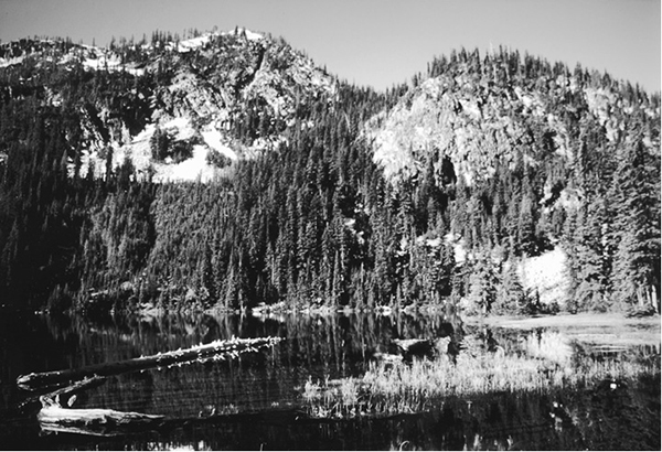
McAlester Lake