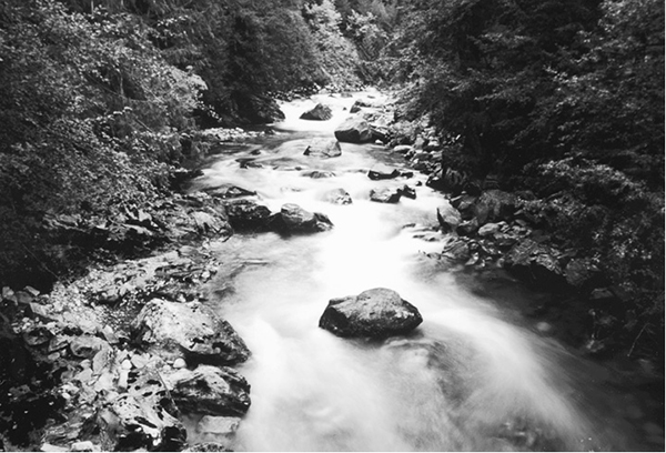
Stehekin River at Turnwater
76 Stehekin Valley Road
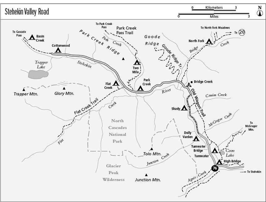
A gravel access route for hikers, bicyclists, and motorcyclists, 11.1 miles from High Bridge to Cottonwood.
Best season: Mid-May to late October.
Elevation gain: 1,380 feet.
Elevation loss: 190 feet.
Maximum elevation: 2,750 feet.
Topo maps: McGregor Mountain, Goode Mountain; McGregor Mountain.
Jurisdiction: North Cascades National Park.
Finding the trailhead: High Bridge marks the start of the route; take the shuttle bus or hike up the road 10.5 miles from Stehekin.
The Hike
This gravel trunk road runs from the boat landing at the head of Lake Chelan to Cottonwood Camp, following the Stehekin River all the way. Shuttle bus service once carried hikers along the entire length of the road, but floods during the winter of 1995 caused the road’s closure at High Bridge. Shuttle bus service may not be consistent along the trail route’s washed out areas from Stehekin Valley’s largest recorded flood, in fall 2003. In the interim period, parts of the road are open to hikers and horses, and Old Wagon Road provides alternate access up the valley. All camping areas along the road are considered backcountry sites for permit purposes. Permits can be obtained free of charge from the Golden West Visitor Center or from other ranger stations around the North Cascades. Hikers on the Pacific Crest Trail (PCT) should note that Old Wagon Road parallels the Stehekin Valley route from Bridge Creek to High Bridge, linking the two points by trail (discussed in detail at the end of this hike description). During times when the main road has been washed out, Old Wagon Road provides a secure alternate route.
The trekking begins at High Bridge, and on the far bank of the river are two distinct trail junctions: first the PCT along Agnes Creek, then the short, dead-end Agnes Gorge Trail. High Bridge camp is on the opposite side of the road, with a long downward trek required to reach the river. McGregor Mountain is the stony massif to the east. The road climbs briefly, then levels off. It soon passes Tumwater Camp, sited above a roaring section of white water, then drops to cross the Tumwater Bridge. There are good views of the rapids from here. The road then climbs onto the bluffs east of the river, and here a cutoff trail links up with Old Wagon Road, a connecting trail that parallels the roadway, slightly to the east.
Stehekin River at Turnwater
The main road now descends to the riverbank, passing beneath overhanging outcrops and small waterfalls as the river courses through turbulent riffles and turquoise pools. Dolly Varden Camp occupies a picturesque riverside spot, while Shady Camp lies a mile upstream in a grove of old spruce and cedar. Beyond it, the road snakes high onto a wooded terrace, then continues north to find Bridge Creek Camp beside the limpid waters of a woodland brook, which is Clear Creek. Old cabins and a horse corral lie beyond the camp, and after passing these structures, the road reaches a junction with the segment of the PCT that follows Bridge Creek. Bridge Creek itself is crossed a short time later, and this major tributary stream has carved for itself a deep channel in the bedrock. Its turquoise waters slide downward through a series of falls and deep pools, then swirl around a stony island just below the bridge.
On the far bank of Bridge Creek is a junction with the Goode Ridge Trail. The road now follows a great westward bend in the valley, climbing gently into a Douglas fir woodland. Hikers get several views of the river along the way, and downriver views reveal the arid western face of McGregor Mountain. The trees begin to thin near Park Creek, revealing mountains ahead. Glory Mountain hulks to the south of the valley, while the summit of Booker Mountain guards its north side. The trail to Park Creek Pass departs beside a creekside camp, and after climbing onto a rise, the Flat Creek route splits away to the left. A short side trip along this trail is a must; within 100 yards there is a bridge spanning a small but breathtaking gorge on the Stehekin River. Flat Creek Camp is on a short spur trail on the far bank.
Meanwhile, the road continues upriver beneath the stony cliffs of Glory Mountain. About halfway between Flat Creek and Cottonwood, the river has adopted the roadbed as a flood channel. There are several tricky crossings beyond this point, and wheeled vehicles must stop here. The forest dwindles away into brushy bottomlands, and the blunt summit of Pelton Peak rises ahead. As the road approaches Cottonwood Camp, the summits of Trapper Mountain and Hurry-Up Peak can be seen above the low headwall that serves as a natural dam for Trapper Lake. The road ends in a riverside grove of Douglas fir and cottonwood. Cottonwood Camp provides spots to pitch a tent, and from here the trail to Cascade Pass continues westward along the river.
Miles and Directions
0.0High Bridge.
0.1 Agnes Creek Trailhead.
0.15 Agnes Gorge Trailhead.
0.2 High Bridge Camp.
0.7 Tumwater Camp.
0.9 Tumwater Bridge. Road now follows east bank of river.
1.7 Dolly Varden Camp.
3.1 Shady Camp.
4.2 Road crosses Clear Creek to reach Bridge Creek Camp.
4.4 Bridge Creek Trailhead.
4.5 Road crosses Bridge Creek to reach Goode Ridge Trailhead.
6.7 Road crosses Park Creek to reach Park Creek camp and trailhead.
7.0 Flat Creek Trailhead.
9.8 First of road washouts. Improvised trail follows river channel with several crossings.
11.1 Road ends at Cottonwood Camp.
Old Wagon Road
This alternate route up the middle Stehekin Valley offers a primitive experience. You will have periodic views of the surrounding foothills through the trees, but none of the views are dramatic. From High Bridge, Old Wagon Road ascends steadily through an open woodland of Douglas fir. Soon it meets the trail to Coon Lake (an easy side trip) at a marked junction. A brisk climb then leads to the crossing of McGregor Creek in its shady forest of cedars. After a short descent, the path swings north into the Shady Burn of 2005. A short jaunt leads across the burn, then into an ancient stand of cedars beyond it. After a short trek in the shade, the forest opens out into a brushy woodland. Here, it meets a connector to the Stehekin Road. The main trail continues north, meandering its way through a pleasant mixed forest to emerge just south of Bridge Creek Camp.