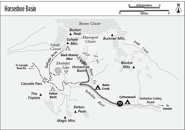
77 Horseshoe Basin
A half-day side trip from the Cascade Pass Trail junction, 3 miles round-trip, or a long day trip from Flat Creek, 15.5 miles round-trip.
Best season: Late June to mid-October; Cascade Pass does not become snow-free until mid-July.
Elevation gain: 2,085 feet.
Elevation loss: None.
Maximum elevation: 4,840 feet at Black Warrior Mine.
Topo maps: Cascade Pass, Goode Mountain; Cascade Pass, McGregor Mountain.
Jurisdiction: North Cascades National Park.
Finding the trailhead: The trail begins at Cottonwood Camp at the end of the Stehekin Valley Road.
The Hike
This trek follows the abandoned mining road that once led to the Black Warrior Mine. The mine site is one of the finest examples of hard-rock gold mining activity in the North Cascades and is listed on the National Register of Historic Places. It could hardly have been blasted into a prettier site: Horseshoe Basin is lined by steep cliffs, and impressive waterfalls tumble down them from the glaciers above. Hikers begin their trek at High Bridge and hike 11 miles up te Stehekin Valley or approach the hike over Cascade Pass, a total distance of 7.6 miles one-way from the Cascade Pass trailhead.
From the well-marked junction, the Horseshoe Basin spur trail climbs vigorously across the north wall of the Stehekin Valley. After a short distance, the old roadbed swings into the valley of Basin Creek, which is filled with a dense growth of slide alder and can offer brushy traveling. The climb eases as the trail makes its way up the valley and soon offers spectacular views of the headwall that surrounds the Horseshoe Basin. More than a dozen breathtaking cascades grace the cliff walls, converging on the valley floor from Davenport Glacier on the flanks of Sahale Mountain as well as from permanent snowfields on Horseshoe Peak to the east of it.
Near the head of the basin, the alders give way to dense swards of fireweed that grow on the alluvial fan of Basin Creek. A southward glance reveals the majestic north face of Glory Mountain, with Trapper Mountain and Pelton Peak west of it. The old road now zigzags up the steep apron of boulders at the head of the basin, bound for the yawning mouth of the Black Warrior Mine. The entrance to the mine sits atop a mound of tailings, beside the base of one of the largest waterfalls. Long-lasting snow bridges make the final approach to the mine portal a hazardous one—beware of falling rocks from the cliffs above the portal.
Initially worked for gold in 1891, the Black Warrior Mine was abandoned after the initial gold rush subsided in 1914. The mine was reopened after World War II in response to surging silver and copper prices, but the operation fell prey to low-grade ore, avalanches, and rockslides. Living quarters and a generator shack were blasted into the rock at the mine’s entrance and are still recognizable today. The cable tramway that once linked the road to a number of mines above the cliffs has long since fallen into ruin. The site is protected by federal law; do not enter the mine, and remember that it is illegal to deface or remove any of the artifacts.
Miles and Directions
0.0 Cottonwood Camp Trailhead. Hike west on Cascade Pass Trail.
1.4 Basin Creek Camp.
1.5 Trail crosses Basin Creek.
2.2 Junction with Horseshoe Basin Trail. Turn right.
2.6 Horseshoe Basin.
3.7 Trail ends at portal of Black Warrior Mine.
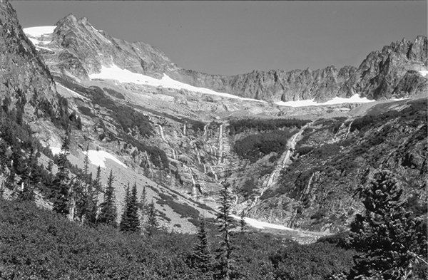
Waterfalls in the Horseshoe Basin