A somewhat challenging but hugely satisfying and varied loop hike beginning and ending at Westwood Lake, but featuring a long ridge walk high above the lake, with views over Nanaimo and its harbour.
LOCATION
From Highway 19 as it passes Nanaimo, turn west (away from downtown Nanaimo) on the southern exit onto Jingle Pot Road. (Jingle Pot Road has two exits). Drive for 500 m, turn onto Westwood Road and proceed for just under 300 m. Turn right onto Arbot Road and drive 1.5 km. Turn into the small but well-signposted parking area on the left.
DISTANCE
9.5 km for full loop
ELEVATION GAIN
230 m (410-m high point)
DIFFICULTY
This is among the more challenging walks in this book, though (older) kids aplenty are to be seen along the trails. The gauntlet has been thrown! There are two or three places where you must take care because the rocks are quite steep, but, except for the threat of muddy feet and tired little legs, don’t expect real difficulties. Because you need to find your way through intersecting trails – some of them for mountain biking, only some of them signposted – take only resilient children who can put up with the possibility of getting a little sidetracked.
SEASON
All season, though the usual warning about snow at the top holds. Even with snow on the ground, a well-trodden path is usually beaten at least to the summit. The full ridge is somewhat less used. Summer is obviously best if a long walk is to be followed by a refreshing dip in the lake.
OF SPECIAL INTEREST FOR CHILDREN
The views verge on breathtaking, of course, but otherwise, the promise of a swim at the end of the walk can be a good incentive.
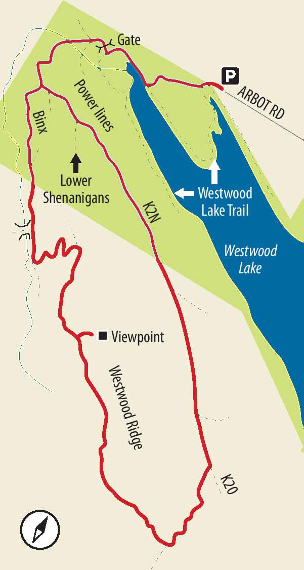
1.Drop down the ramp-like trail and merge right to join the main Westwood Lake Trail, heading northwest. Ignore the mountain-biking trail forking off to the right and, subsequently, Lake Trail running along the edge of a peninsula that juts into the north end of the lake. Instead, take the signposted shortcut across the peninsula to rejoin the main Lake Trail. Cross a bridge and switchback up a bank to another split in the trail.
2.At this point turn right to head towards nearby power lines, passing a sign about the dog off-leash area ahead. Pass through a metal gate and go straight ahead under the power lines, ignoring a trail to the right. The road-width trail curves uphill to the left, but within a very short distance leave it to follow a heavily eroded trail to the right, heading into the forest. You should see a faded, handmade sign saying “Kil-patrick” high on a tree.
3.Upon entering the forest, the trail is a bit of a mess because of erosion and intersecting foot and bike traffic. Forge ahead a short distance until you come to a kind of crossroads. High on a tree you should see a carved wooden sign saying “Binx.” This is the trail you want. At this point – and some others – you share the trail with mountain bikers. Be prepared to jump off the trail and offer a cheerful greeting to the bikers staring with concentration as they bounce down the path past you.
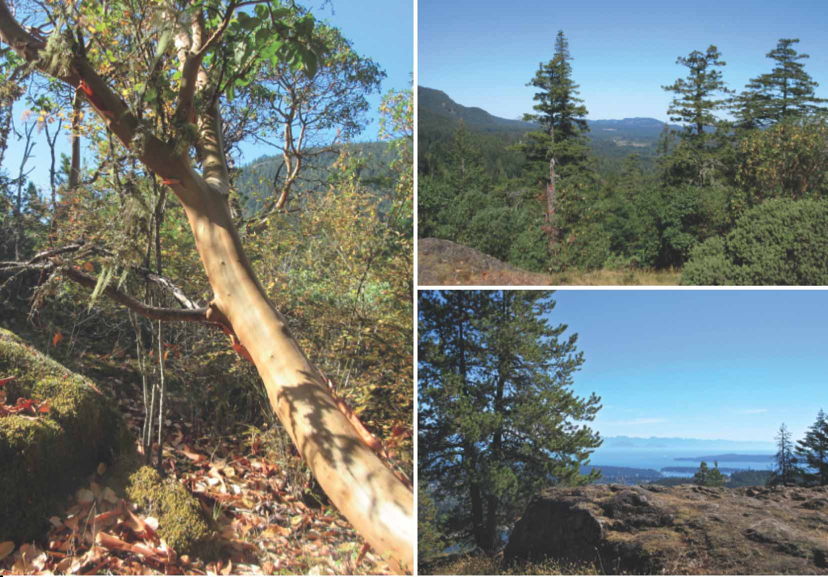
CLOCKWISE FROM ABOVE LEFT The ridge trail is rich with arbutus; the first viewpoints look towards the northwest past manzanita bushes and arbutus; from near the high point, with Gabriola and Protection islands; manzanita bushes frame the view towards Departure Bay.

4.On this next section, the trail rises towards the end of the ridge, traversing along its southwest side. Pass several preposterously scary-looking wooden structures created by daredevil mountain bikers. As the trail passes the end of the ridge, still within a forest primarily of Douglas fir, it starts to follow the line of the ridge and a small stream on your right.
5.When you see a small bridge crossing the stream, perk up: you soon switch trails. Coming to a comparatively new trail entering from the left – at this writing marked with orange flagging tape – turn left. Here you begin to climb up the ridge, via a well-engineered mountain-biking trail, switchbacking dramatically.
6.After several switchbacks, you come to the top of the ridge and a kind of T junction. Turn right to climb the ridge. From here for most of the ridge itself you are on a trail primarily used just by walkers. The downside is that, though the trail is well-used, it is a little less obvious than the one you were just on, particularly when it crosses rocky bluffs.
7.Trending generally up the right side of the ridge, the trail very soon brings you to a zone of arbutus and lovely little manzanita. Climbing steadily, you soon have several photo-worthy views towards Mt. Benson and, once you reach the high point and cross the ridge, over Westwood Lake and Nanaimo Harbour. Even with snow on the ground, this is a popular destination – and, given the wonderful view, unsurprisingly so.
8.While many hikers turn back here, you can have more of an adventure if you carry on along the ridge. The ridge is broad at this point with the main trail running largely down the right (southwest) side. Entering thick forest, you must step over a few fallen logs and may find the trail a little faint where there is no underbrush. Some kind soul, however, has tied clusters of red and blue flagging tape along the trail from here to the end of the ridge.
9.Partway down the ridge, the trail turns to your left to cross a steep, bare-rock slope, the only part of the trail where care really needs to be taken. Shortly after, the trail swings left to begin a mostly direct, quite steep descent down a dirt bank. Levelling off at one point, and changing direction slightly, it completes the descent more or less before angling to the left and, eventually, converging with a mountain-biking trail marked with a sign saying “K20.”
10.This well-used trail, mostly parallel to the lake, is your route back to the beginning. To your right, beneath some large cedars and firs, by a large cairn, note another biking trail signposted “Mother’s Trail.” (The actual name is a little less heartwarming!) When you come to a distinct split in the trail, a Regional District of Nanaimo (RDN) signpost indicates that the left fork is a mountain-biking trail. This is the trail you want. As always, be mindful that it is courteous to step aside if a mountain biker grunts sweatily past. (In fact, this trail is popular with mountain-biking families with young ’uns.)
11.After a very long section, gradually descending, there is a log fence and a converging trail labelled “Lower Shenanigans.” Looking back, you see that you have been following a trail labelled “K2N.” Carry on, gradually descending, ignoring converging trails, until you come back to the sketchy crossroads with the sign for Binx. Turn right to retrace your way back to your vehicle – and, on a hot day, the potential for a refreshing dip at the large beach park a few minutes’ drive away.