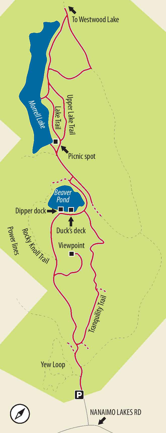
A maze of trails leading to a rocky knoll of manzanita and arbutus, a viewing platform over Beaver Pond, and a lakeside route amongst cedars.

LOCATION
From the Nanaimo Parkway (Highway 19), turn east (towards downtown Nanaimo) at the traffic lights signposted for Fifth Street and Vancouver Island University. Drive 800 m, turn right onto Wakesiah Avenue and proceed for 270 m. At Nanaimo Lakes Road, turn right and drive 1.2 km, until you see the sign for Morrell Nature Sanctuary on your right.
DISTANCE
4 km
ELEVATION GAIN
75 m
DIFFICULTY
Easy level paths most of the way. The side route to the top of a rocky knoll and viewpoint is a little rougher. At one or two spots, newly fallen arbutus leaves in July can be slippery.
All season, but there a few slightly wet spots in winter. Beaver Pond can be nearly dry at the end of a long, dry summer.
Of Special Interest for Children The most distinctive features of the route include the high viewpoint, so-called Beaver Pond, and Morrell Lake itself. All should appeal to different facets of your child’s personality. The lake isn’t brilliant for swimming, but it does have a little beach and a picnic area (with washrooms), so there is plenty of opportunity for getting up to no good.
1.Walk straight ahead from the parking lot, passing the administrative office, side trails to wheelchair-accessible routes and, later, Tranquility Trail. Pass through the gate appealingly signed for Rocky Knoll Trail. Ignore a second sign for Tranquility, and soldier on through sword ferns and cedars, some of them large and buttressed with enthusiastically writhing roots. If you have the right kind of child, do take time to pause at the interpretative signs for Indian pipe and western coral root, both about as weird and wonderful as local flora get.
2.As the trail rises through a drier and rockier area, notice other signs, most notably for the comparatively rare hairy manzanita, a truly wonderful kind of miniature arbutus. Pass a picnic table and climb some dirt-and-timber stairs until you come to an unlabelled fork in the trail.
3.Not on most maps of the park, the side trail to the right leads to arguably the loveliest spot in the park, though it is a dead-end trail requiring you to return to this spot. Take a deep breath and begin the ascent over largely bare rock, through arbutus and – bonus! – lots of manzanita bushes. The park bench perched on the perfect viewpoint makes both a good rest spot and good turnaround point.
4.Return to Rocky Knoll Trail, turn right and within a few steps, find yourself with two branches both leading along Beaver Pond Loop. Take the trail to the right and, within mere minutes, come to a sturdily built boardwalk leading you to Dipper Dock and a viewpoint for a pond, Duck’s Deck, and the wildlife it contains. Unfortunately, it is unlikely to contain any wildlife if you arrive at the end of a dry summer, when not a trace of water is to be found.

FROM LEFT An unusual view of Mt. Benson from the side trail to the viewpoint; the northwest end of Morrell Lake.
5.Returning to the trail, turn left to follow the shore of the pond. Note the side trails. Take the third of these through a gate leading a short distance to a service road and turn left. If you see an “11” on a post on Beaver Pond Trail, you’ve gone too far; turn back to find the short route to the service road. A few steps along the service road brings you within sight of the clearing by Morrell Lake.
6.The little beach isn’t quite Copacabana, but children can be easy to please as long as there is water to hand. After using the beach, picnic table or outhouses, carry on around Morrell Lake. At a few points there are very pretty views, though prettier looking along the lake rather than across it, unless you have a morbid interest in power lines. Notice the two trails leading away from the lake, since you use them on your return route.
7.Be careful – the trails at the end of the lake are configured differently from what maps typically show. Once at the end of the lake, take the trail leading directly away from the lake and come to a T junction with a broad trail (leading, if you were to turn left, towards Westwood Lake). Turn right, climbing gradually along a broad, gravelly trail under alders.
8.Before long, on your right, notice the brown gate and sign for Lake Trail (called “Connector” on some maps). Turn down this trail until you get to the lake. Turn left to repeat a short distance along the lakeside trail before turning left onto Upper Lake Trail to loop back to the head of the lake and the service road. This trail rises slightly and drops down some dirt-and-timber stairs. Although it is well away from the lake, you can see the lake through the bare trunks of second-growth Douglas fir.
9.Now that you’re back on the service road, carry on past the first trail to Beaver Pond, and take the second one. This will allow you to make the short connection at Beaver Pond to Tranquility Trail, your route back to the beginning. This trail, so named it seems because it has no distinctive visible features, rolls purposefully along through blankets of salal and large trees, roughly parallel to the rocky knoll, rising on your right. Ignore Lookout Trail on your left (unless you want to make a short return trip) and carry on to a fork. Here you can turn either right or left. Both directions will deliver you after a short distance to your starting point.